

EWSHR

Early Warning Service of Health Risks due to atmospheric pollution caused by abnormal weather conditions
Project completedEWSHR delivered two online services for monitoring and early warning of health risks related to air pollution: a WebGIS platform on air quality and health risks, and an app providing real-time assessment of pollutant concentrations and health risks from exposure.
Overview
Context
Under global climate change, abnormal weather patterns will continue to happen in frequency over the next decades with significant impacts on ecosystems, economies, and communities. Abnormal weather, such as heatwaves, unusual snowstorms, flooding, and droughts, can manifest as extreme or unusual weather events that may be more intense, frequent, or prolonged than observed. According to the WHO, an estimated 7 million people die prematurely each year from diseases linked to air pollution, including stroke, heart disease, respiratory disease, and cancer.
Objective
The project aims to develop regular monitoring and early warning of the risk of exposure to air pollution aggravated by climate change to mitigate the impact of these harmful air pollutants on human health. This early warning ensures climate change adaptation strategies are responsive to real-time pollution threats while addressing long-term climate resilience, particularly in vulnerable regions or countries. It can also empower individuals or vulnerable groups (e.g., children, elderly, people in precarious situations or with chronic illnesses, outdoor workers) to take real-time, personalized actions to reduce exposure risks. Meanwhile, better health and well-being bring significant economic benefits and are therefore integral to ending poverty and reducing inequalities around the world.
End users
This online service is intended for a wide range of users to guide prevention, policies, and personalized protection measures.
- Environmental and health departments and governments can formulate corresponding risk prevention and control measures based on the analysis results of online services.
- NGOs and scientists can utilize historical results such as on pollutants, health, and health risk to analyze inequities in exposure to atmospheric health risks associated with extreme weather. They can also conduct policy research aimed at promoting fairness in environmental health exposure.
- The general public can take personalized health risk avoidance measures based on the early warning results.
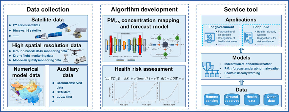
The overall framework of EWSHR © Central South University
Application site(s)
Changsha, China
Data
Satellite
- Fengyung (FY) series
- Himawari-8.
Other
- Monitor data: ground-based air quality monitoring data, ground-based LiDAR monitoring, mobile air quality monitoring data.
- Meteorological numerical model data products.
- Auxilliary data on land use and land cover, roads and pollution sourcs, DEM (Digital Elevation Model).
Results - Final product(s)
The product is an interactive online map service including a WebGIS Platform and an individual app. Users can create an account via the login interfaces.
Air Quality & Health Risk Platform : https://www.kingvil.com/sco/#/
The platform is for the environmental departments, governments, NGOs and scientists, including modules of monitoring station, satellite observation, air pollution mapping, and health risk assessment.
|
|
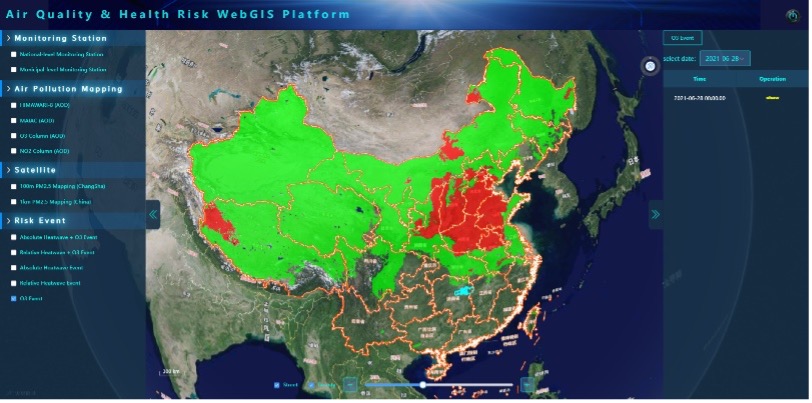
Users can make use of the pollutant concentration analysis and early warning results provided by the project to formulate regional and hierarchical control measures, which greatly improves the efficiency of precise control.
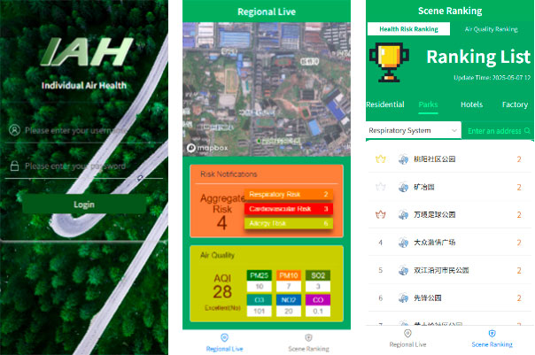
IAH Application, Individual Air Health : http://120.26.101.68:11111/health-app/#/
|
Available to the general public, the app provides the real-time pollutant concentration and health exposure risk assessment results of the user's location under abnormal weather conditions. It also provides real-time health risk rankings and air pollution ranking (PM2.5, ozone, etc.) for each typical scenario (residential, park, hotel, factory). Long-term exposure trends are also recorded and analyzed to provide more accurate health services to users. |
|
Related project(s)
- 🇨🇳 SCO DUST : an early warning system for intense dust and haze episodes in China
- 🇨🇳 SCO AEROPMAP : AEROsol and Particulate Matter MAPping in China
- 🇫🇷 SCO FLORIA : Automatic monitoring of air pollution in Western Europe and North Africa
Project news
- 🎥 24/02/2026: Presentation of the EWSHR project and its progress at the 3rd ClimateSCOpe “From space to health”