

SCOFrance
4Open-access demonstrators (Atlantic, Brittany, Normandy, Gulf of Lion)
Useful linksLittosat Atlantic Interface
Littosat project
Littosat SA project
Keywords
Foreshore, intertidal zone, vegetation, spartina, macroalgae
LITTOSAT covers the entire Atlantic coast
In September 2024, they had warned us: their remarkably operational demonstrators were just the beginning of a bigger story. This one is unfolding by the sea.
Chapter 1: Littosat Brittany and Normandy
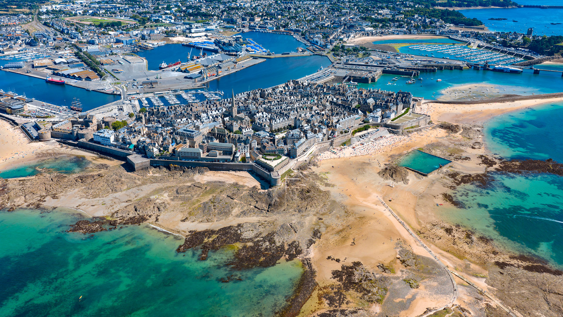
Are you familiar with the foreshore, also known as the intertidal zone? It’s that stretch of land that emerges at low tide, where people -often families- go to collect crabs, clams, scallops, razor clams, gobies… As attractive as they are fragile, these ecosystems are deteriorating, and their preservation is now the subject of national and European directives.
In late 2021, the innovation company Hytech-imaging applied to the SCO call for projects: with its Littosat project, it proposes using Sentinel-2 imagery to build a tool capable of monitoring the health of foreshore vegetation each season, at both high and low tide. With SCO support and through intensive collaboration with the two pilot regions, they are refining the data processing workflows and developing a mapping interface tailored to the information needs of coastal managers. This has led to the creation of two demonstration projects: Littosat Brittany and Littosat Normandy.
👉 Learn more about this chapter: News from September 17, 2024, Littosat is fully operational and can be transposed to coastal monitoring
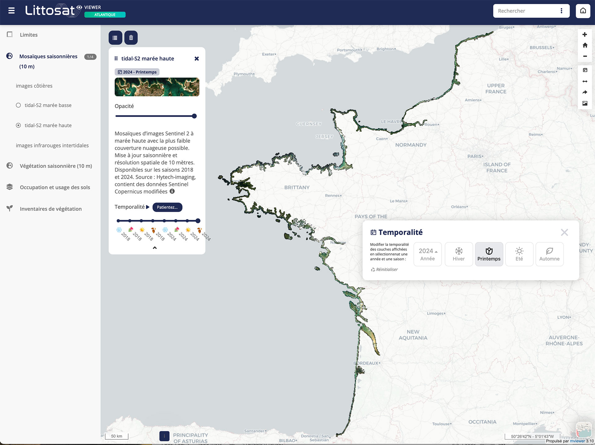
Chapter 2-1: From Dunkirk to Biarritz, Littosat Atlantic
By late 2024, Hytech-imaging is confident: they know they have built a robust interface, and they designed their service to be replicable and customizable. Their proposal is selected for the European Coastal Hub call for projects, launched with a view to future Mercator Ocean coastal services.
For 18 months, they work tirelessly to extend Littosat to the entire English Channel-Atlantic coastline by adding the Hauts-de-France, Pays de la Loire, and Nouvelle-Aquitaine regions, for which seasonal “mosaics” are available for the two reference years, 2018 and 2024.
|
🖱️ Try LITTOSAT Atlantique, a tutorial is available to help you get started |
 |
At the same time, in response to requests from the highly engaged user community in the pilot region, they are expanding the time coverage of Littosat Brittany, moving from the original two-year reference period to complete data spanning the seven years from 2018 to 2024!
Chapter 2-2: New Data and New Features
Also as part of the Coastal Hub, Hytech-imaging is integrating Copernicus products into Littosat:
- Coastal Land Cover/Land Use data from the Land Service (CLMS), which, at very high resolution, complement the mapping of coastal land land use beyond the foreshore;
- data from the Marine Service (CMEMS), which provide new indicators, including sea surface temperature and chlorophyll content.
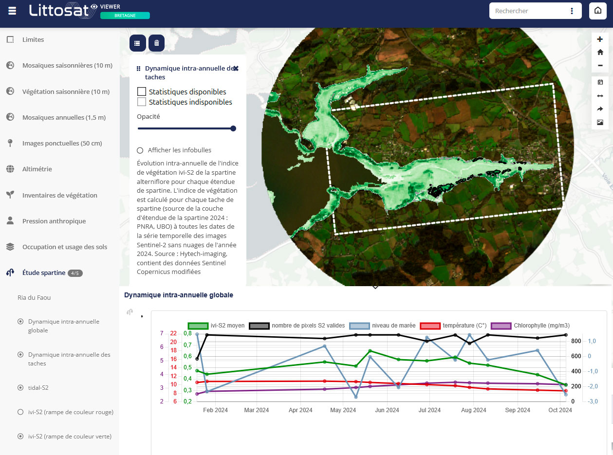
Two use cases are then tested to evaluate new Littosat features and enhance the interface with graphical visualization (curves) of the indicators’ temporal evolution.
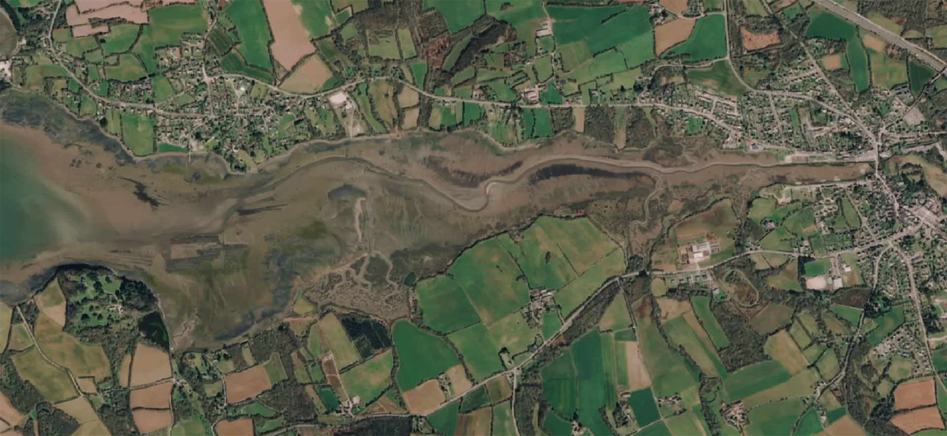
🌱 The first case focuses on Spartina, an invasive species of the foreshore. Results from the Ria du Faou study area (Finistère department) have enabled its managers to better understand the early phenology of this plant, which allows it to colonize the mudflats before other species develop. By tracking Spartina’s development in near real time, Littosat will soon make it possible to identify areas where this species is declining naturally.
👉 Learn more here.
|
► Very high spatial resolution (THRS) Pleiades image used to create the Coastal Zones product for the Ria du Faou. © Airbus DS |
|
|
► Littosat dashboard for monitoring the interannual dynamics of Spartina:
©Hytech-imaging
|
|
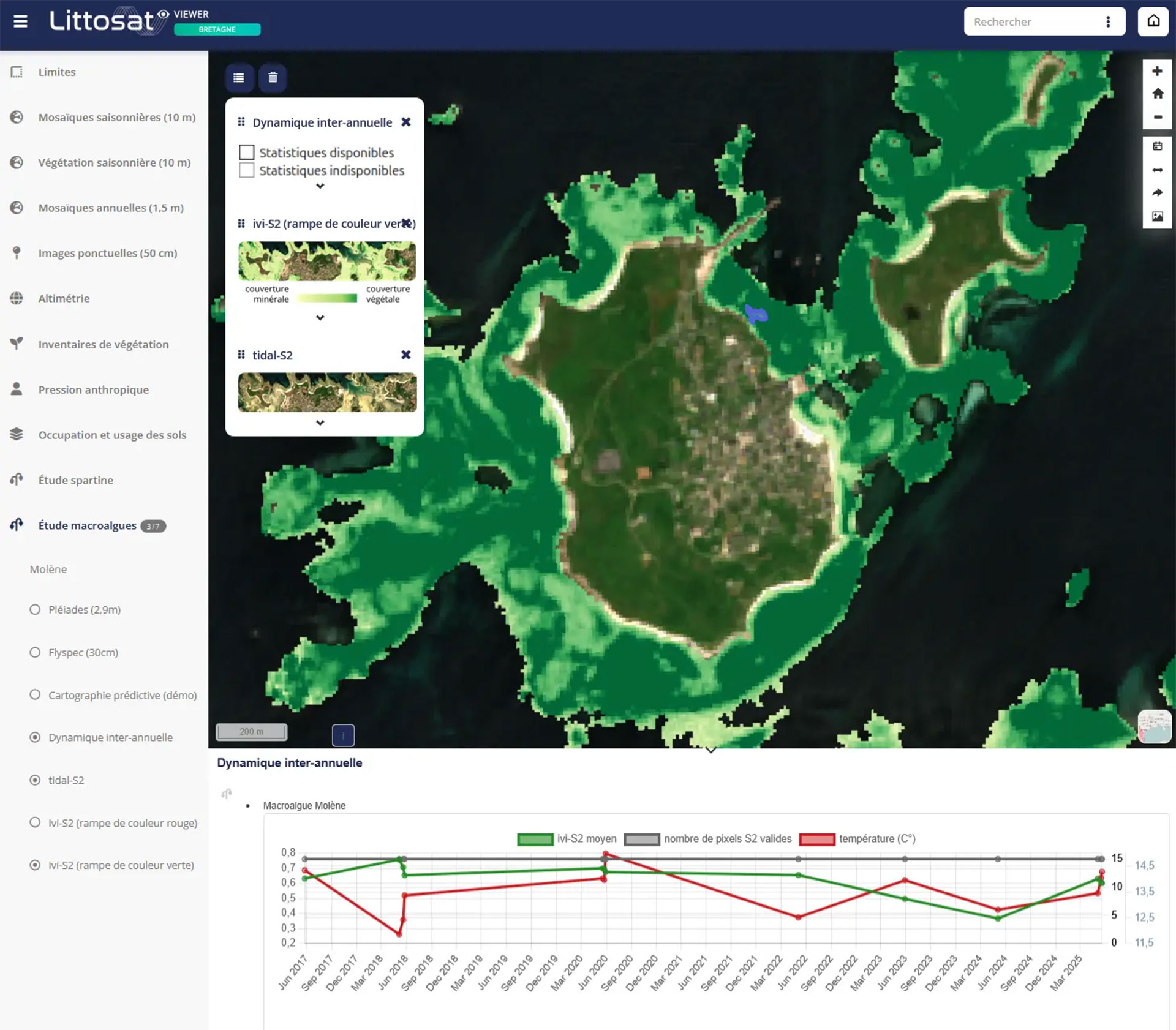
🌱🌱 The second use case addresses the needs of the LEMAR university research laboratory, which is responsible for monitoring intertidal macroalgae in Brittany. The regularly updated monitoring of macroalgal coverage will be invaluable for better understanding the regression of certain belts and their correlation with variables such as temperature. Work is ongoing to automate and extend this service to other coastal areas.
👉 Learn more here.
|
► Preview of a Littosat dashboard for monitoring macroalgae:
©Hytech-imaging |
|
“Still in the POC (proof of concept) stage, these two use cases have generated significant user engagement, particularly with our ‘macroalgae’ partner responsible for the Water Framework Directive (WFD), with whom we are continuing our work through the national France 2030 program dedicated to coastal zone monitoring,” comments Marie Jagaille, Littosat project lead at Hytech-imaging.
Chapter 3: Littosat South Africa
Many countries have coastal zones. Building on its French demonstrators, Hytech-imaging proposed adapting Littosat to the South African coastline, which is particularly vulnerable to the impacts of climate change. Accredited with SCO in 2025, the Littosat SA project is just getting started. With support from the South African space agency SANSA, the project will deploy data layers and specific tools co-developed with local stakeholders.
Epilogue: Unity is strength
As you can see, Littosat’s story has been built on collaboration, and it’s far from over! Marie Jagaille, who has been dedicated to the project from the start, praises “the SCO and Copernicus’s support through the Coastal Hub. They are remarkably effective catalysts, enabling us to engage in long-term co-creation with users, ensuring that the results -and how they are presented to users- align with their needs. All this support has also been crucial in consolidating our service offering, which otherwise likely wouldn’t have reached the maturity needed to clear the “hurdle” of the POC. Furthermore, thanks to them, we have presented Littosat at 18 events over the past 18 months, reaching an audience of over a thousand potential users! This is invaluable to us as an innovative SME, and for all of this, we sincerely thank them. Today, this impressive progress is fueling our enthusiasm to deploy Littosat SA and thus test the robustness of the processing chains and the relevance of our user approach in a region very different from France.”
The bottom line: see you soon for new Littosat adventures!
|
Marie Jagaille, the face of Littosat It’s been four years since SCO and Hytech-imaging have been working together, a journey that Marie Jagaille elegantly summarizes in under two minutes.⏱ |
|