

Littosat South Africa

Satellite dashboard of foreshore vegetation
Overview
Context
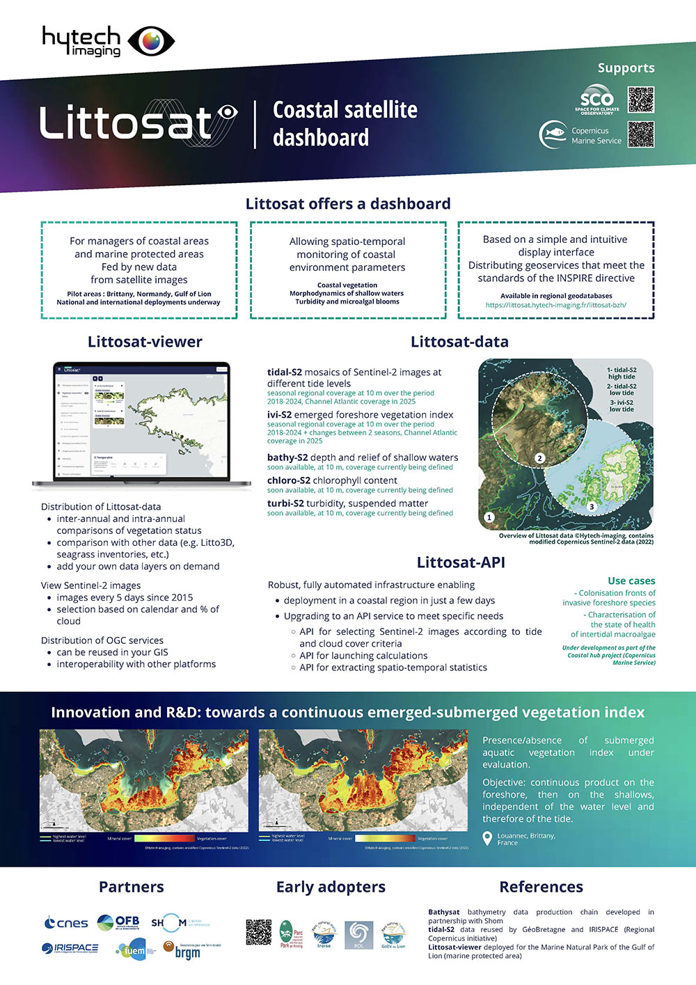
The coastal zone is currently home to 60% of the world's population, soon to rise to 75% by 2050, despite representing just 20% of the planet's habitable surface. This coastal strip is the focus of major challenges. It is home to remarkable habitats (coral reefs, seagrass beds, seaweed beds, lagoons, mangroves, etc.) that are home to a large proportion of the world's biodiversity, as well as the major resources and ecosystem services needed to sustain human life. More specifically, the foreshore, a tidal zone, is a part of the coastline that is still poorly covered by satellite products, which were first developed for maritime and continental areas. Managers of coastal areas, and more specifically marine protected areas, need tools to monitor their territories.
In this context, Hytech-imaging has developed a range of data and services providing information on the spatio-temporal evolution of intertidal vegetation, with the support of the SCO (Call for Projects 2022) for seasonal regional deployment in 2 pilot regions (Brittany and Normandy). Then with the support of the Coastal Hub (Mercator Ocean International and CMEMS), for deployment in mainland France (Call for projects 2024) and to establish an initial API offering for access to the image selection infrastructure and vegetation index calculation capabilities.
👉 Littosat product sheet in the Resources section below
Throughout the process, a section on the appropriation of satellite products and tools by end-users was set up. A group of key national users has been involved as partners since the beginning of the project.
What does Littosat-SA offer?
Here, Hytech-imaging proposes to deploy Littosat in South Africa, following the same philosophy, with:
- the deployment of the infrastructure to produce satellite data and data access services.
- the deployment of specific data layers and tools co-constructed with local players.
- user support, with the support of the South African Space Agency (SANSA), as the focal point for links with end-users, specification of the Littosat-SA service, dissemination of results and capacity-building at local level.
Who are the end-users?
The end-users are the local authorities in charge of managing coastal areas in South Africa, and more specifically marine protected areas (MPAs). To this end, we will identify a group of early adopters at the start of the project, with the support of SANSA.
Deployment specifications from Littosat-France to Littosat-South Africa
Littosat-SA will offer a range of data :
- tidal-S2 coastal mosaics of Sentinel-2 images at high and low tide
- an ivi-S2 vegetation monitoring product for the cloud-free intertidal zone at high and low tide
- a diff-ivi-S2 product for changes in vegetation status between different periods of the same year (intra-annual), or between two years (inter-annual).
The existing infrastructure will be used. Some adjustments to the geographical sector may be necessary.
Littosat-SA will offer a viewer, in its v1 version, as it currently exists (pilot region: Brittany and France Manche-Atlantique deployment for 2025). This v1 allows the data described above to be distributed via a simple, intuitive, open-source web interface.
In parallel with deployment, a user-centric approach will be implemented. These users will play an active role in defining the specifications of the tidal-S2 and ivi-S2 products (range, temporal frequency).
An R&D component is planned to enhance the data offering, with:
- an extension of the ivi-S2 vegetation index to the submerged zone of the foreshore, including the evaluation of this index and its deployment on relevant zones to be defined with local users.
- according to the needs expressed by local users, the development of specific indicator(s) for monitoring local issues.
A development phase will also be planned to add functionalities to the viewer, transforming it into a dashboard. The latter will be based on:
- the implementation of APIs, for example to monitor areas of interest, to be identified with the user.
- the development of new viewer functionalities co-constructed with local users (e.g. display of vegetation evolution graphs).
Local partners will be sought at the start of the project.
Application site(s)
South Africa
Data
Satellite
Sentinel-2
Other
The search for local data will be carried out at the start of the project.
Results – Final product(s)
The following products are expected:
-
Littosat-South Africa visualization interface
-
tidal-S2 coastal mosaics of Sentinel-2 images at high and low tide, systematically at regional scales, with a multi-annual update frequency and 10m spatial resolution
-
ivi-S2 vegetation monitoring product for the cloud-free intertidal zone at high and low tide, updated every few years at a spatial resolution of 10m.
-
diff-ivi-S2 product of changes in vegetation status between different periods of the same year (intra-annual), or between two years (inter-annual).
Related project(s)
- SCO Littosat (Call for projects 2022)
- Coastal Hub (Coastal and Arctic Hub User Demonstrations -24262-COP-Coastal &Arctic Hubs Uptake- 8000)
Project news
🎥 04/07/2025: Presentation of LITTOSAT at the 1st ClimateSCOpe “Monitoring our oceans”
Resources
 |
Littosat product sheet
|