

SCOFrance
Useful linksORION project page
Key wordsMountains, mountain pastures, pastures, moors, pastoralism, fauna, flora, plant colonisation
ORION delivers new tools for mountain environments
Remember: the project began in autumn 2021 with a virtual space for immersive discussions on ORION's expectations and objectives. Twenty months later, the method has proved its worth, with valuable indicators for mountain managers, in this case the Chamonix Mont-Blanc Valley Community of Municipalities (CCVCMB, Communauté de communes de la Vallée Chamonix Mont-Blanc), a long-standing partner of CREA Mont-Blanc, which is piloting the project.
For the record, the ORION project was born:
|
🏔 from one observation: the lack of tools and information on the dynamics of heathland, these low ligneous plants such as rhododendron, whose expansion is probably encouraged by climate change and which is causing an impoverishment of floristic diversity, the main resource for both wildlife and pastoralists. |
🛰 from a technical and scientific breakthrough: in 2016, CREA Mont-Blanc and the LECA alpine ecology laboratory used new near infrared channels on Sentinel-2 satellites to detect the accumulation of red pigments in moorland canopies, particularly in autumn, paving the way for detailed detection of habitats using space imagery. |
To provide managers of the CCVCMB with concrete information, the project used Sentinel-2 images to produce:
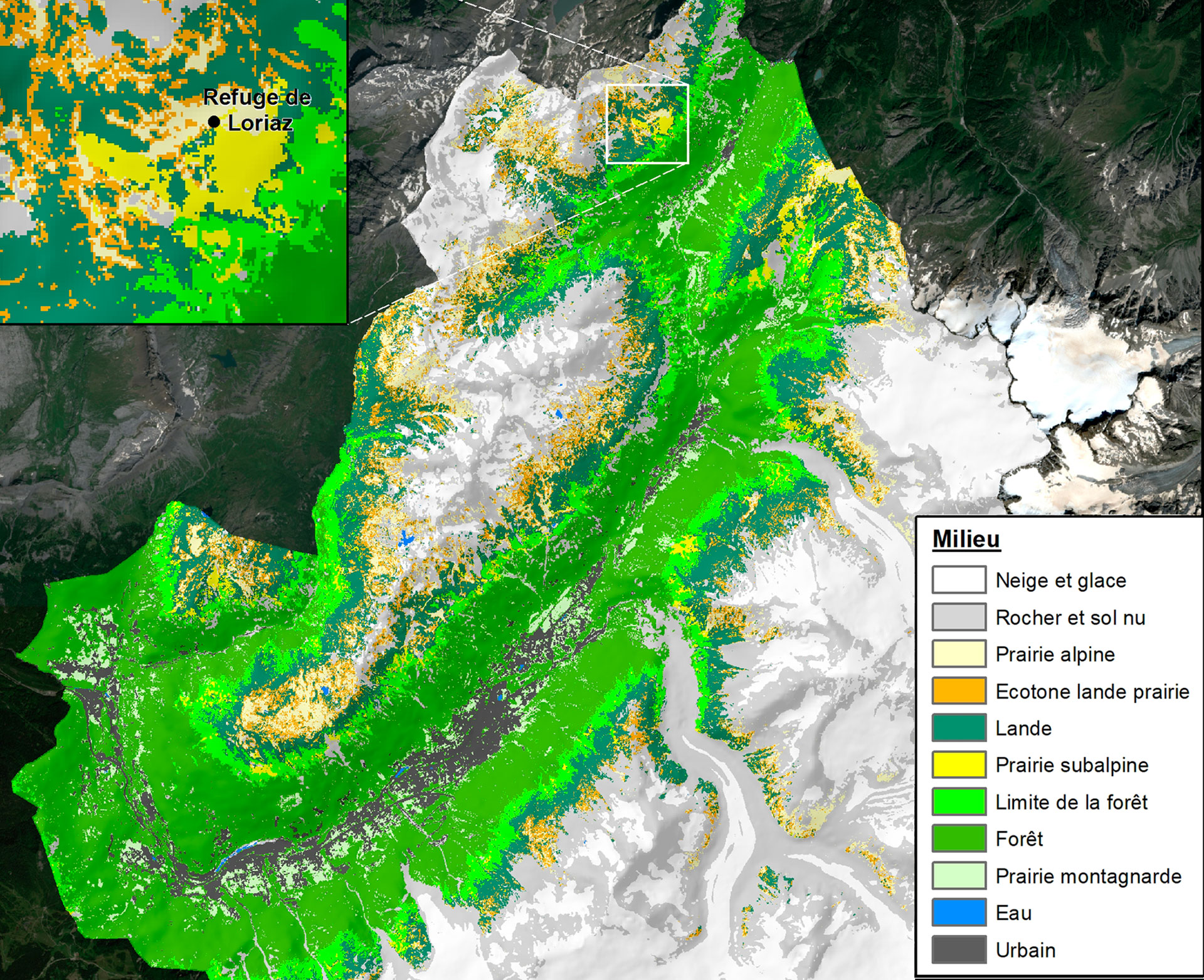
- Detailed mapping of 11 habitat classes, validated thanks to the remarkable efforts of volunteers in the field (142 habitat surveys, 11,000 height and soil measurements, recognition of 22,785 plants)
👉 Sentinel-2 imagery offers 3 major added values:-
A resolution of 10 m, much more precise and richer in information than the tools available on a regional (OSO) and European (Corine Land Cover) scale;
-
Automation: the map can be updated over the coming years with new Sentinel-2 images.
-
Adaptability: the tool can evolve, for example to add a sparsely vegetated rock class to monitor the colonization of vegetation by retreating glaciers. [This phenomenon is the subject of the study Future emergence of new ecosystems caused by glacial retreat, published in the journal Nature in August 2023].
-
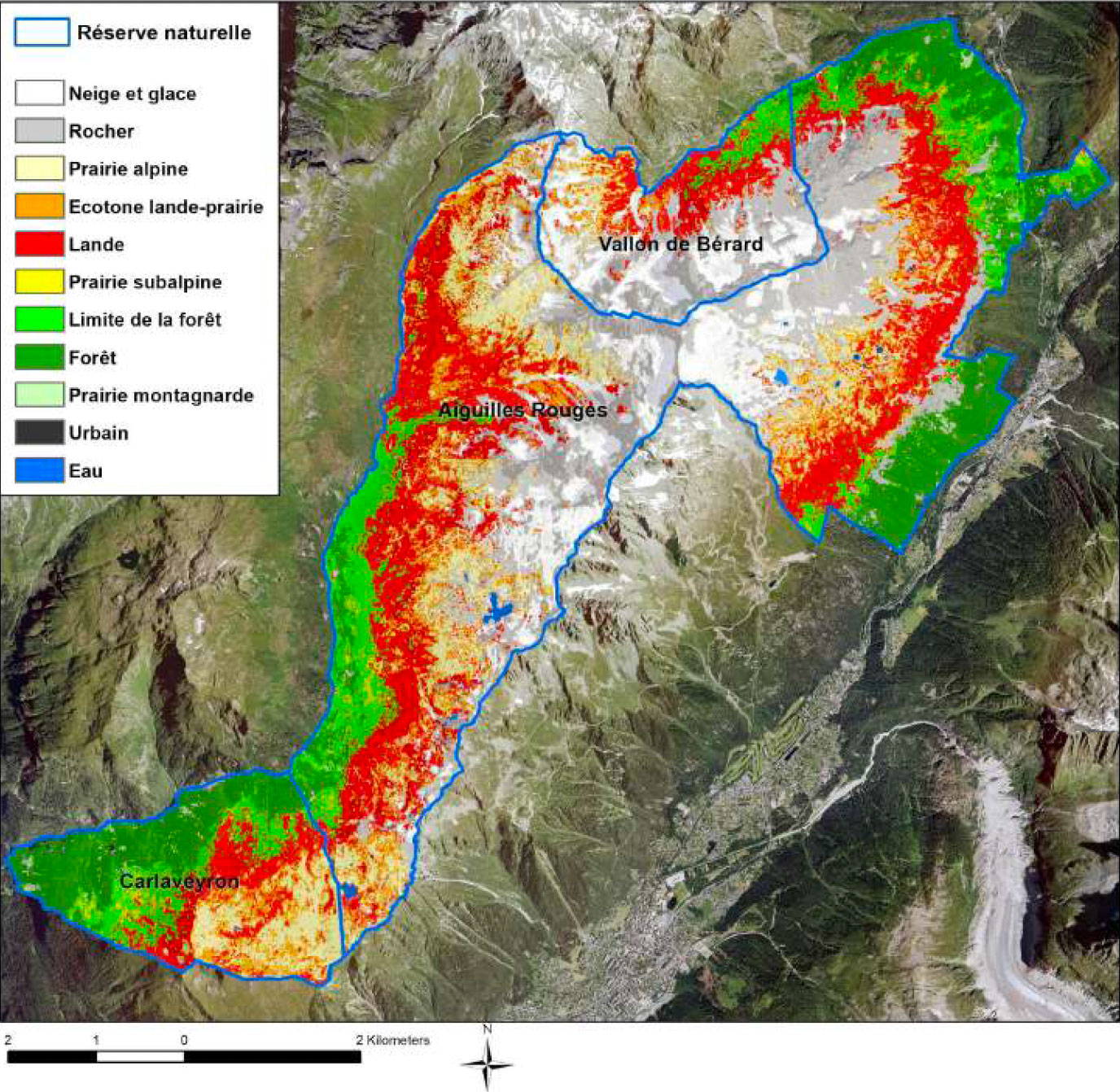
Extract from the map of habitats within the perimeter of the CCVCMB nature reserves. Thanks to the latest generation of satellites, ORION is able to distinguish moorland (shown here in red), a complex target to capture because this sparse vegetation, often in a mosaic, is intermingled with meadows and rocks. © CC BY 4.0 CREA Mont-Blanc
-
Floristic and faunistic diversity indicators, obtained by cross-referencing the results of ORION with those of the network of photo traps set up by CREA. These indicators make the link between geospatial habitat and the structure of available habitat favorable to species, and are key to refining management and consumption plans for certain species. In the same spirit, the Herbiland project, also supported by the CREA, which sees it as an extension of ORION, is devoted to gaining a better understanding of fauna/flora interactions in heathland environments.
-
Identification of vulnerable (high stakes) areas: in this case, the CREA has endeavored to develop an adaptive monitoring indicator for mountain pastures in relation to pastoral management and climate change (what area can be used by herds). This can be used, for example, to assess whether it is appropriate to keep a given area open, or to see whether climate change is favoring the expansion of moorland in place of grassland, etc
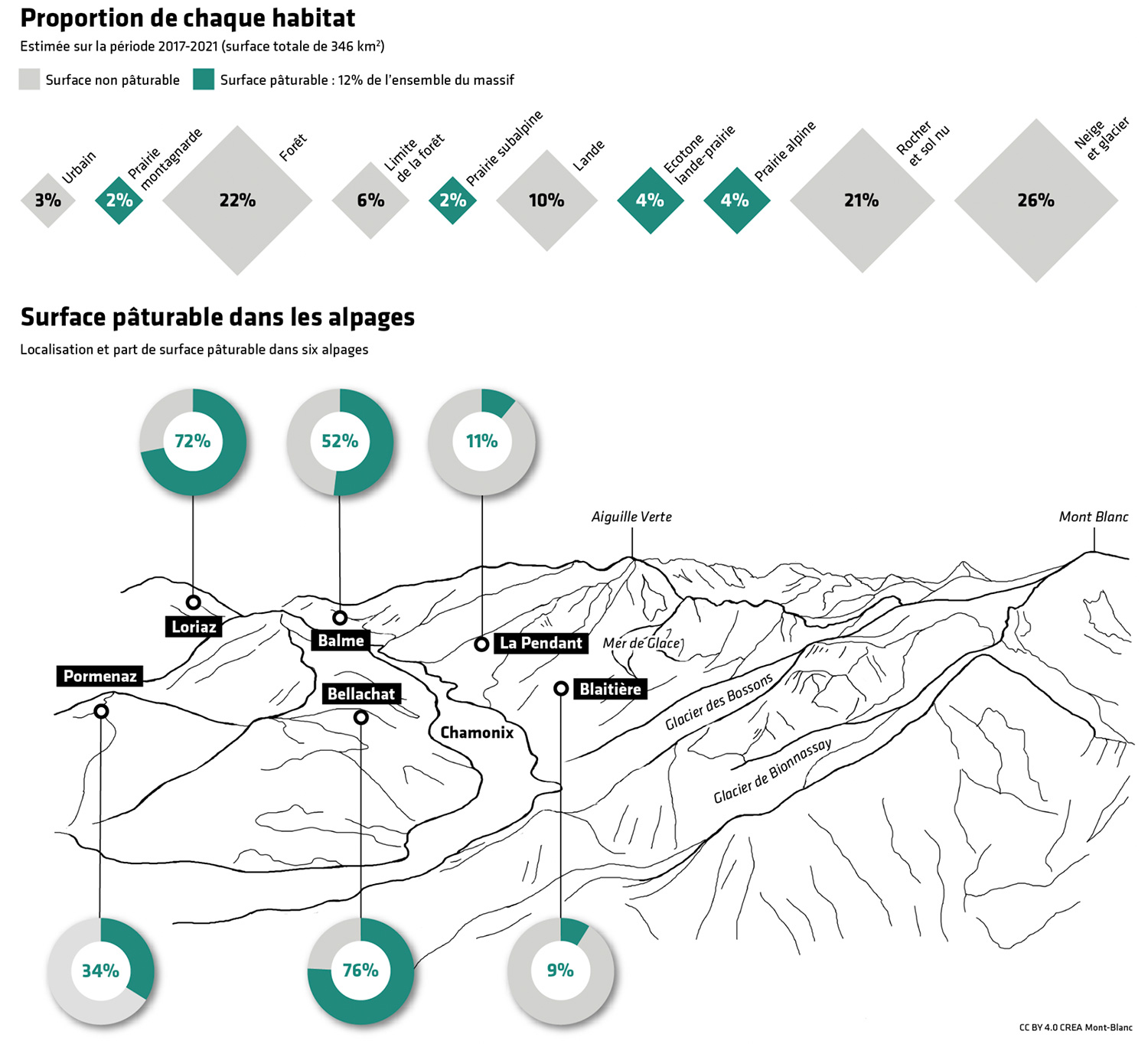 |
◀︎ Indicator developed as part of the ORION project using satellite monitoring of a grazed area. © CC BY 4.0 CREA Mont-Blanc |
Today, CREA is sharing the ORION results directly on the (splendid) Mont Blanc Atlas institutional website (in French):
👉 page Alpine meadows, pockets of resistance to understand the issues;
👉 page Satellite monitoring of a "grazable area" to see the indicators developed.
The ORION project page has also been updated to summarize the issues, methods and results, including the final report available to download.
Users have their say
"A mountain pasture that is no longer grazed, or is grazed poorly, quickly becomes overgrown with moorland and loses its economic value, which is difficult, if not impossible, to recover. We have high expectations of a tool like ORION, which can provide us with a global and quantified vision of the evolution of the various environments in the region, especially in the context of climate change.” Jean-François Deshayes, Councillor responsible for the Natural Areas, Agropastoralism and Forestry Commission of the Chamonix Mont-Blanc Valley Community of Municipalities.
"The tool created as part of ORION could facilitate the monitoring carried out as part of the work we are doing on the impact and role of pastoralism in the dynamics of certain plant formations, particularly heathland. If the results show very slow or absent changes, we could use them to advocate the free evolution of environments rather than interventionism, for example. The tool could also be used for aspects linked to climate change, for example for our Ice and Life project on proglacial margins. We still need to validate the accuracy of the tool by comparing it with our own data.” Carole Birck and Lisa Wirtz, respectively in charge of scientific strategy and expertise at the Haute-Savoie Conservatory of Natural Areas ASTERS.