

ORION

biOdiveRsity Impacts of shrub expaNsion
Project completedAfter 20 months of development, the ORION project has delivered high-resolution mapping of 11 habitat classes in the Mont-Blanc massif, as well as indicators of fauna and flora diversity, including an indicator of grazing area. The results of this work are freely available on the Mont-Blanc Atlas website.
OVERVIEW
While the upper limit of the forest has been studied and monitored for many years, the distribution of low woody species (or heaths) in the Alps is often poorly taken into account in the mapping and management of mountain environments. However, heaths represent today a structuring and sometimes dominant habitat of mountain vegetation cover. Their expansion at the expense of grasslands leads to a certain number of "ecosystem disservices", i.e. functions that are perceived as negative for ecological functioning and human well-being. The replacement of mountain meadows by heathland i) leads to a local decrease in floristic diversity, ii) modifies plant resources available for herbivores (wild and domestic) and iii) alters the mountain landscape from the point of view of tourists and hikers. In recent years in the Alps, a strong expansion of heathland has been observed, which has been favored both by climate warming leading to a reduction in the duration of snow cover, but also by the abandonment of pastoralism in favor of tourism.
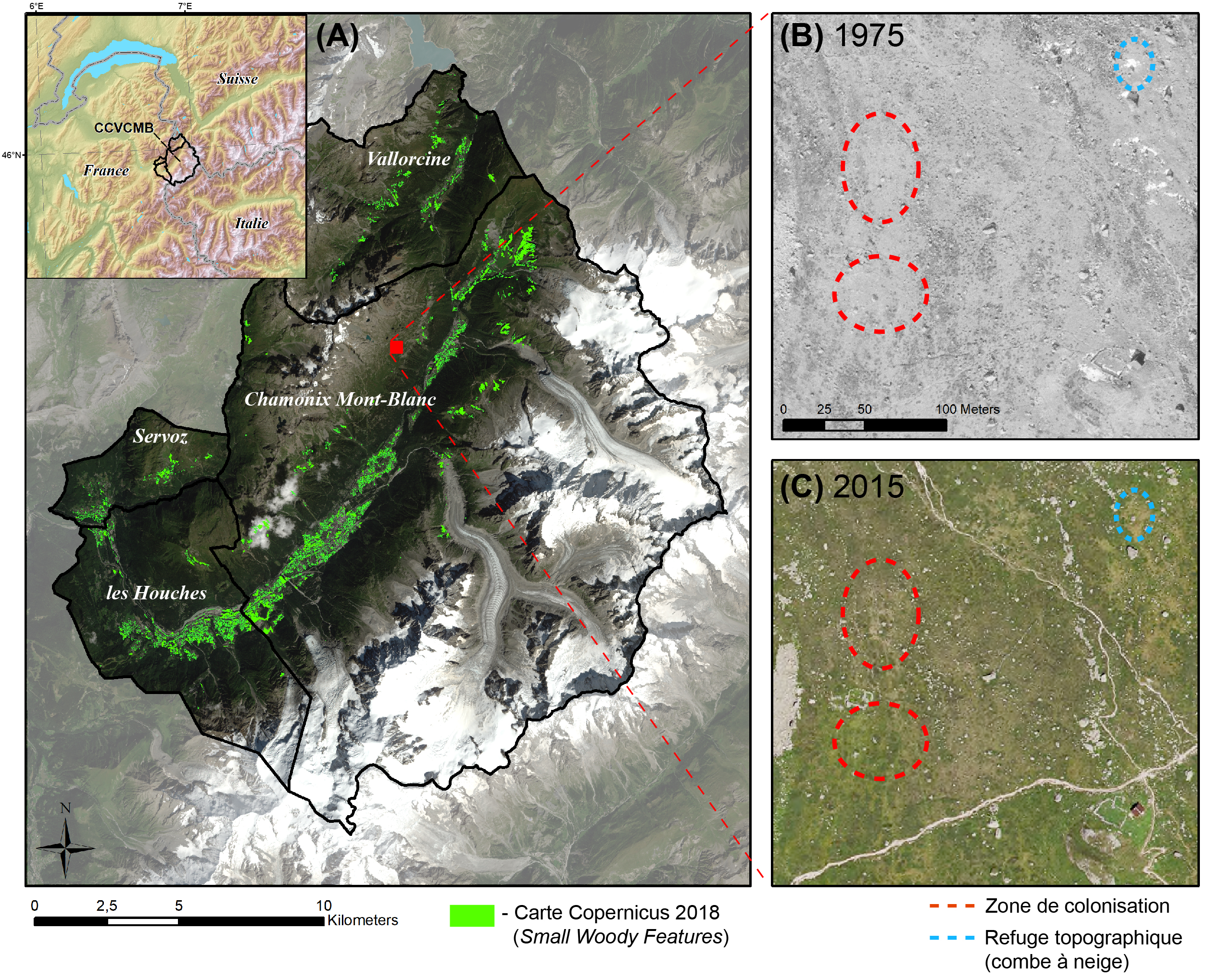
The Mont-Blanc massif is an emblematic site of the effects of climate change in the Alps. In the same way as the melting of glaciers and permafrost in the high mountains, the erosion of biodiversity is a critical consequence of global warming to be monitored from the point of view of land management and conservation.
The commissioning of the Sentinel-2 satellite offers scientists and decision makers the possibility of improving spatio-temporal monitoring of mountain environments, thanks to improved spectral, spatial and temporal resolution. Botanical surveys carried out in the field will allow for quantifying the consequences of the expansion of the moors on plant diversity, in particular that of meadows. Otherwise difficult to observe, "camera traps" will make it possible to observe wildlife and its use of mountain habitats with varying degrees of shrub cover.
The ORION (biOdiveRsity Impacts of shrub expaNsion) project consists of providing operational services to decision-makers to help them manage the expansion of heathlands on their territory. We propose a multi-trophic approach that aims to understand the consequences of grassland closure on floristic diversity and habitat use by large wild herbivores (mainly deer, roe deer and chamois).
© CREA Mont-Blanc
Application site(s)
The Community of Communes of the Chamonix-Mont-Blanc Valley, France
DATA
Satellite
Sentinel-2A et -2B
Other
- Botanical (phyto-sociological) field surveys
- Phototrap images
- High resolution DTM
RESULTS - FINAL PRODUCTS
The ORION project provides a number of tools for managers of natural areas:
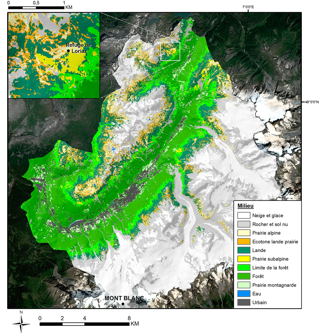
High resolution (10m) and replicable mapping of habitat distribution from Sentinel-2 satellite images and validated by ground observations
|
|
◀︎ Figure1. Final habitat map of the Chamonix Mont-Blanc Valley Community of Municipalities for the 11 classes modelled. The zoomed-in map at top left shows the spatial variation of habitats in the Loriaz mountain sector in the Vallorcine commune. © CREA Mont-Blanc |
|
|
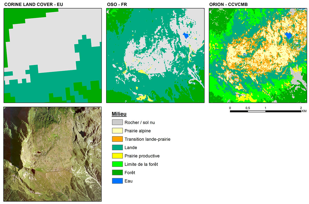
◀︎ Figure2. The mapping produced is superior to existing products on a French (OSO) or European (CORINE) scale, thanks to the selection of explanatory variables used, the local calibration of the algorithm in the Chamonix valley, and the habitat classes modelled, which include transition habitats (forest limit and heathland-grassland ecotone). |
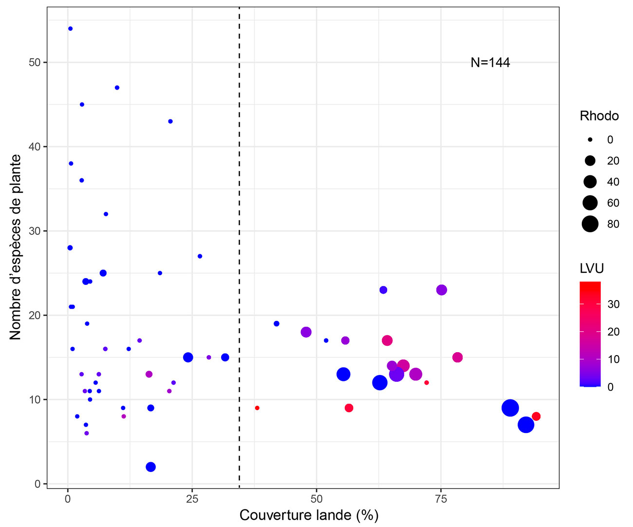
Indicator of floristic diversity as a function of heathland cover based on botanical surveys
|
► Figure3. Variation in plant species richness as a function of moorland cover for 144 phytosociological surveys carried out by the CBNA above 1700 m in Haute-Savoie. The size of the dots corresponds to the percentage cover of rhododendron (Rhodo), while the color corresponds to the percentage of blueberry (LVU). A decrease in floristic diversity can be seen at heathland cover levels of over 30%. © CREA Mont-Blanc |
|
Habitat-based indicator of large herbivore use from camera traps
|
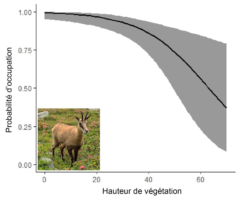
▲ Figure 4. Occupancy probability curve (i.e. detection by photo trap) for chamois as a function of plant canopy height. The statistical uncertainty of the curve is represented by the grey area showing the standardized error. |
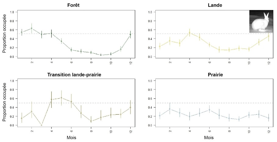
▲ Figure 5. Proportion of photo-trap sites occupied by the variable hare as a function of month of the year and environment, estimated from a site occupancy model. The species seems to prefer to spend winter in woodland and summer in transitional areas between heathland and grassland. |
Mapping of the areas at stake on the territory of the CCVCMB (Community of Communes of the Valley of Chamonix-Mont-Blanc), including identification of the vulnerable meadows likely to be colonized by heath
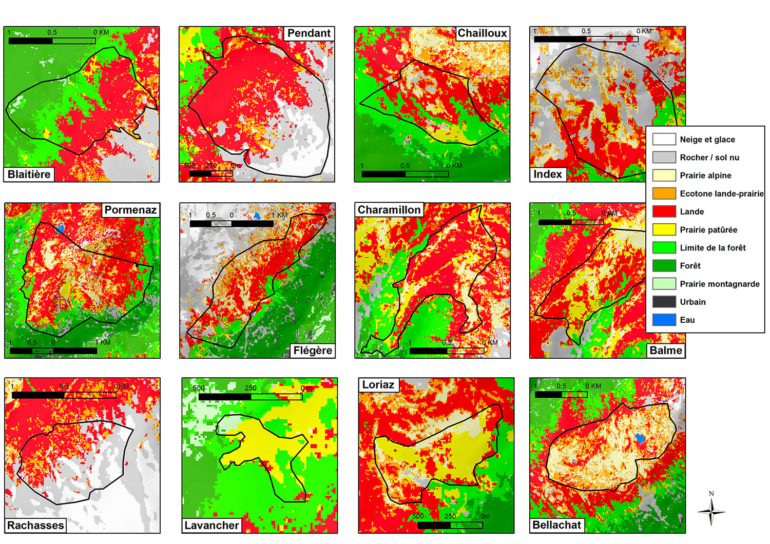
▲ Figure 6. Extracts from the habitat map for each mountain pasture in the CCVCMB. The Blaitière, Pendant and Rachasses mountain pastures have very little continuous grassland, although graminoids and forbes are certainly intermingled in the moorland and provide a certain amount of pastoral resources. In this case, the Bellachat, Loriaz and Le Lavancher mountain pastures have large expanses of grassland. We can deduce that these meadows are maintained by historical and current pastoral activity, as they are surrounded by moorland, forest or both. © CREA Mont-Blanc
Availability of indicators and associated data to managers, in the form of GIS data and a data visualization portal on the Mont-Blanc Atlas website (in French):
- Alpine meadows, pockets of resistance page to understand the issues;
- Satellite monitoring of a "grazing area" page to see the indicators developed.
Available on Flickr (under CC BY 4.0 licence) of the graphic entitled "The habitats of the Chamonix valley".
👉 The method and the work developed are the subject of a final report (available in pdf format in the Resources section below): Carlson B., Bayle A., Bison M. & Delestrade A. ORION: biOdiveRsity Impacts of shrub expansiON in the Chamonix valley. Project funded by the Office français de la biodiversité (OFB) as part of the Space Climate Observatory (SCO) France, 2021-2023. September, 2023, 33p.
References
| ORION on GEO Knowledge Hub, a long lasting digital repository created by the Group on Earth Observations: https://doi.org/10.60566/vx1e0-c2y11 |
Project news
-
09/10/2023: ORION delivers new tools for mountain environments
-
30/09/2022 : Presentation of the ORION project and its progress at the 6th Quarterly Meeting of the SCO France on the theme Monitoring the evolutions of natural areas by remote sensing.
- 29/11/2021 : Welcome to the Alps with Orion