

SCOFrance
PartnersBLUECHAM, DRM, Quintesens, Swati, IRD, Ditra Tech, CSIRO, CNES
Useful linksProject page
Key wordsMarine spatial planning, on-demand processing, DATACUBE, notifications, syntheses, virtual stations
QVX-PF, power made TAHATAI Neo
|
We've been working with this team since 2021 and, truly, they have the art of surprising us with a spirit of innovation that's as effective as it is pragmatic! Remember: with Tahatai, they implemented a marine spatial planning platform on the island of Tahiti and the Arutua atoll. This cutting-edge geographic tool provides indicators on water quality and anthropogenic pressures in the lagoon and along the coast. With Tahatai Neo, which was accredited with the SCO label in 2023, they have set themselves the ambition of extending their system to the entire Pacific and beyond, with enhanced functions. The challenge is well on the way to being met, again based on the vision and needs of the Polynesian Marine Resources Department (DRM). |
Tahatai's foundation: user needs and vision "In Polynesia, we have the largest economic zone in France, with an immense maritime area and thousands of kilometers of ocean and lagoon coastline to monitor. In this context, marine spatial planning is an absolute priority, for which we quickly saw the value of satellite data. With this project, we are making the most of existing data by connecting the growing capacities of satellites, including in terms of revisit frequency. This enables us to monitor, alert, anticipate and prepare for the future on a more regular basis.” Pascal Correia, Marine Resources Department |
More advanced driver functions
According to Rémi Andreoli, project coordinator for the consortium, "our QVX platforms are designed to provide users with solutions to help them better organize their territories, what's more in a context where climate change is having an impact on places and people's lives".
To scale up to French Polynesia, the pilot functions are increasingly focused on meeting the needs expressed by the DRM:
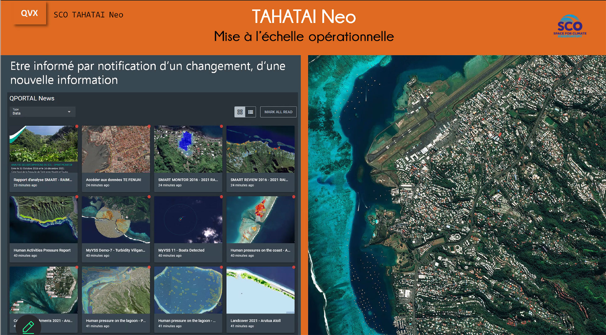
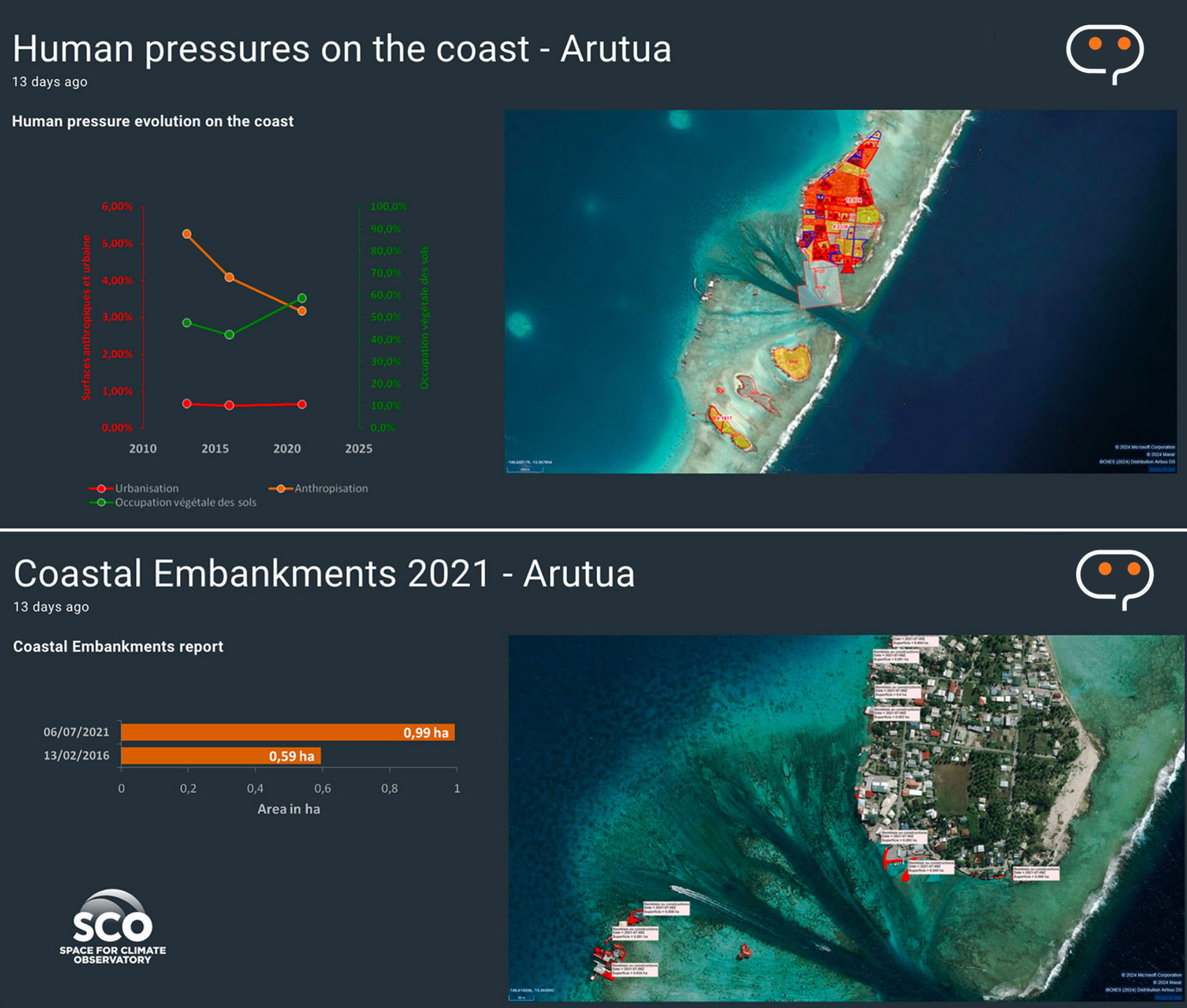
- Be informed by notification of a change, new information 👉 in place, quick visualization on a news page.
|
 |
- Analysis on demand (where and when users want it) 👉 thanks to the platform's PRISM app, users choose an area of interest and then select the treatment they wish to apply to answer their question: coastline/coastline changes, land use, drought, flooding, algae, turbidity, chlorophyll a...
- Access a capitalized history, monitor the present and plan future monitoring 👉 in place via a cloud-based DATACUBE.
- Interoperability with the user's existing business tools 👉 in place
Demo for and by SCO
To show us the performance of QVX-PF and its collaborative power, Rémi Andreoli proposed an unusual exercise to the SCO team present on web meeting: to calculate an indicator together, with each of us having to calculate a small piece of information to, in the end, generate a spatial analysis that brings together all our uses. Intrigued but delighted, we logged in simultaneously while Rémi created a working group with all of us.
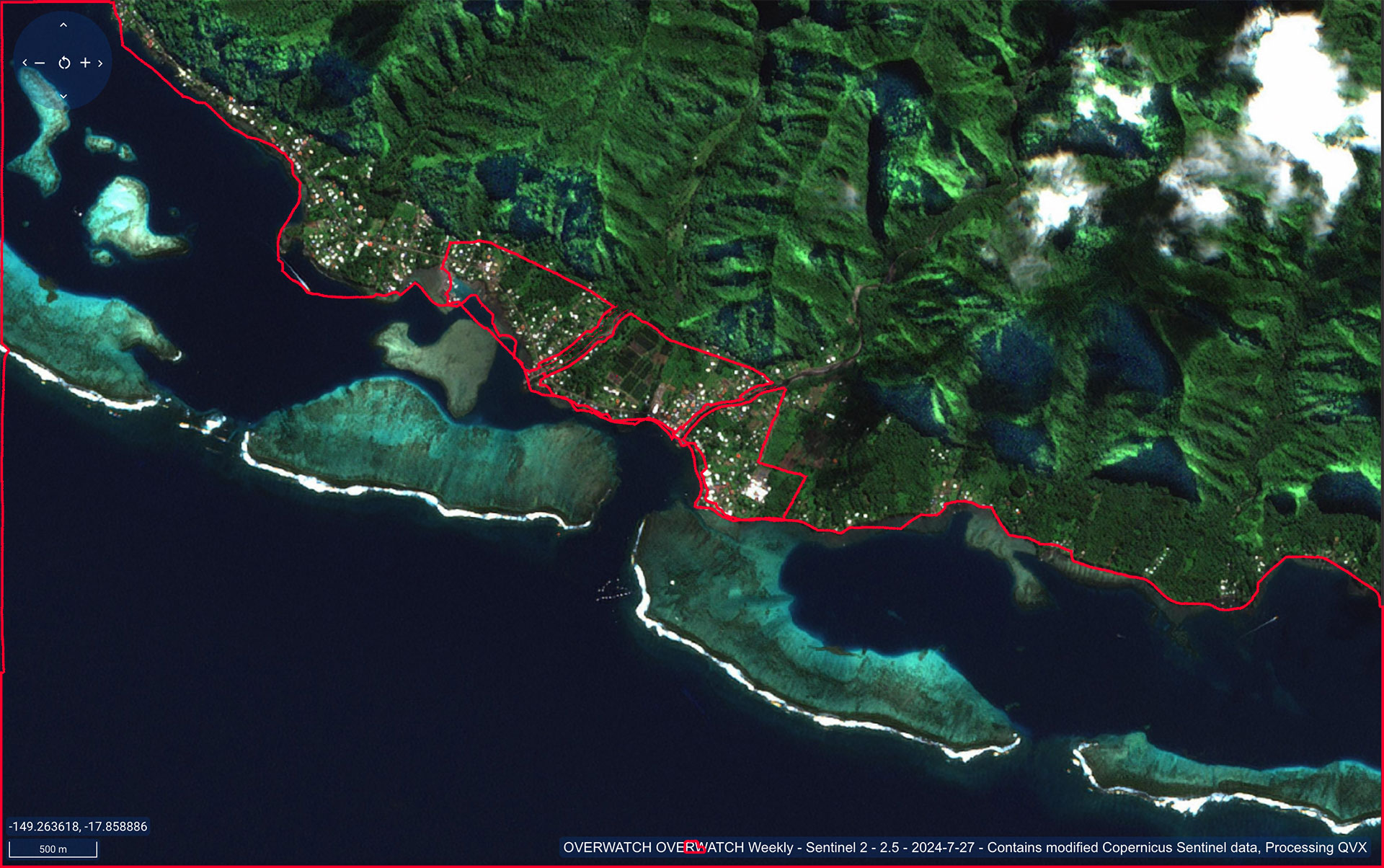
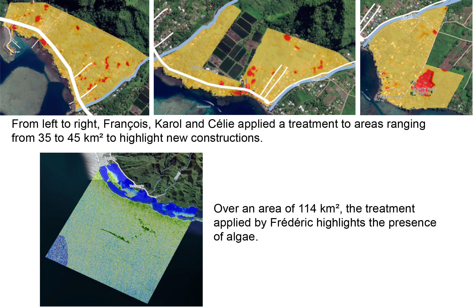
To set the scene, we went back in time to July 2024 to Teahupo'o beach, on the peninsula south-east of Tahiti, which hosted the surfing events of the Olympic Games. First, Rémi showed us two satellite observations, one from July 2024 and the second from July of the previous year, to play on the transparency of these 2 layers of the location and thus visualize the changes between the year of the Olympics and the previous one. We can see new coastal infrastructures and, zooming out, "spots" in the sea. Today's objective: to analyze what these are using the PRISM application to precisely identify areas of change on the coast linked to preparations for the Olympics, and to find out whether the specks in the sea are algae floating on the surface (if not, other analyses such as chlorophyll-a or oil pollution detection can be applied).
|
Rémi then sent each of us, via the workgroup, a kml file defining a different geographical zone. Then he asked us to apply a different treatment to our respective zones:
|
 |
|
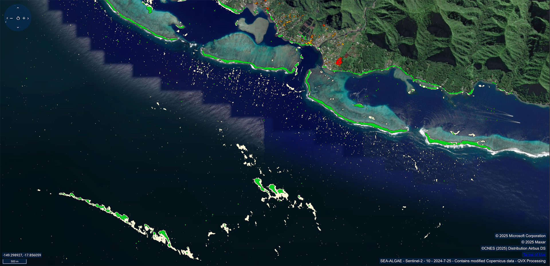
► In just a few minutes, QVX-PF generated the analysis for each of the four treatments: new terrestrial infrastructures stand out in red, while offshore spots turn out to be photosynthetic algal blooms, not pollution. |
|
|
► As each of us is part of the same workgroup, analyses are pooled and each user can view all 4 treatments on the same image. These analyses can also be downloaded from the group's DATACUBE. |
|
VEESAT, a field application for setting up virtual monitoring stations
In the vast geography of French Polynesia, DRM field agents need to be able to focus on certain high-stakes targets: a port, a boat launch, a restricted zone, a suspected abnormal activity...
|
Now, from their cell phone or computer, they can set up a VEESAT virtual station at any time, which will monitor all the requested parameters within a 1 km radius of the geolocated point, each time a satellite passes over it. A tool that Rémi Andréoli compares to "a flashlight that you turn on in the night", to facilitate and sharpen the DRM's reactivity, for example to verify the presence or absence of boats characteristic of certain activities. This new concept was developed by Quintesens, the project's Australian partner. The platform is thus perfectly suited to its role as a cloud integrator. ► When VEESAT is set up, the entire cloud is activated, which means that the user downloads nothing and mobilizes no local infrastructure. Everything is automated, with a notification sent as soon as an indicator changes, in this example if chlorophyll a or turbidity thresholds are exceeded in the monitored zone. © Quintesens
|
|

The home stretch
This is just a sample of the potential of QVX-PF, which will be fully operational throughout French Polynesia within 12 months. Scaling is going smoothly, with archive depth dating back to 2016, and a tutorial is ready to guide new users. Several states have already expressed great interest, including Fiji, Papua New Guinea and Vanuatu.