

TAHATAI Neo

A digital platform for marine spatial planning
Overview
The Polynesian coastal zone is the privileged place of exchanges between the terrestrial and maritime parts where many uses, coastal fishing and dwellings converge. Its proximity to the sea also makes it a particularly vulnerable zone to climatic hazards. It is therefore a complex interface that requires a horizontal, integrated and evolving approach to all the issues.
Within the framework of the overall "Marine Spatial Planning" program of the Government of French Polynesia, this project aims to develop, implement, automate, operate, and replicate on a Pacific scale, useful indicators for the governance of the littoral zone, for decision-makers in charge of maritime and coastal space management.
Conceived as a continuation of the TAHATAI project, TAHATAI Neo aims at the operational implementation of analysis applications dedicated to decision makers and monitoring indicators according to the three axes set up in the TAHATAI project:
- Water quality in the context of climate change (plankton blooms);
- Frequentation and use of the lagoon and coastline;
- Human pressure on the coasts in the context of climate change.
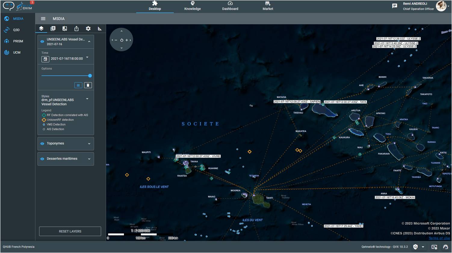
QVX smart Digital Platform and UNSEENLABS radio frequency ship detection demonstrator correlated with the AIS and VMS systems of the Polynesian Government. © BLUECHAM SAS, DRM and UNSEENLABS – TAHATAI Project.
Promote access to data and services for Marine Spatial Planning:
TAHATAI Neo's objective is to massively open the access to the QVX platform to the user communities of French Polynesia and then, by replication, to the countries of the zone, in an approach of international cooperation and co-construction.
The communities addressed are:
1. technical services and decision-makers of the ministries of French Polynesia and of third countries;
2. research and educational institutes;
3. private companies and industrialists;
4. consultants and NGOs.
An innovative digital platform
Beyond the provision of valuable resources, TAHATAI Neo's ambition is to develop an innovative digital platform of French technology as an online operational tool for decision support: the QVX platform.
QVX is home to the implementation of business-oriented applications dedicated to supporting and optimizing decision-making processes by providing relevant information at the moment it is needed. Dedicated applications and/or summary indicators integrated into the dashboard will be available to provide key decision-making elements in a simple consultation. The use of the platform will open up to applications on mobile devices, with the aim of making environmental information accessible to citizens and increasing the impact of the information
Application site(s)
- French Polynesia
- Vanuatu
- New Caledonia
- Australia
- Fiji
- India
- Indian Ocean
DATA
Satellite
- Sentinel-1
- Sentinel-2
- Sentinel-3
- Aqua et Terra MODIS
- SPOT World Heritage
- SWOT
- Pléiades
- Pléiades Néo
- Unseenlabs
- WorldView
- BlackSky
Other
- Copernicus Services
- ECMWF satellite weather data
- Historical data from the Government of French Polynesia
Result(s) – Final Product(s)
TAHATAI Neo focuses, beyond access to data and computing resources, on:
- The deployment of desktop and mobile applications fed by satellite feeds and the added value (indicators) resulting from their processing;
- The realization of the scaling up of the two pilot sites of TAHATAI (Arutua and Tahiti) to the whole of French Polynesia 👉 see the results of TAHATAI
- Automation and security of new real-time processes;
- The deployment of the economic model in French Polynesia to all the actors of the blue sector, then internationally (Vanuatu, Fiji, India);
- The massive opening to the user community of the tools, algorithms and applications developed within the framework of the TAHATAI Neo project via the QVX digital platform;
- The definition of new, complex and innovative processes in conjunction with the actors in the field.
TAHATAI Neo, through the QVX digital platform of French Polynesia, will be the showcase of applications for Marine Spatial Planning focused on the preservation of the blue resource (water quality, human pressures) and the use of lagoon and coastal waters. With a community of users at different levels and use cases, the solution will be extended to other territories according to an adapted economic model, integrated in the QVX Market Place.
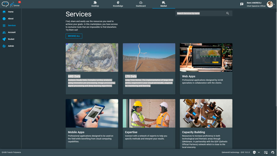
QVX smart Digital Platform : Marketplace. © BLUECHAM
Related projects
Project news
- 11/06/2025: QVX-PF, power made TAHATAI Neo
- 🎥 27/03/2025: Presentation of the TAHATAI Neo project and its progress at the 16th SCO France Quarterly Meeting "Coastal ranges: issues and solutions"
- 30/04/2024: TAHATAI Neo takes shape, project launch