SAGA
System for Anticipating and Managing Green Algae Stranding
Overview
Context
For decades, the bays along the Atlantic Channel coastline have experienced green algae strandings, generally observed in bays with weak residual tidal currents.
| In recent years, new stranding sites have appeared in areas that were previously unspoilt, such as the coastline of the Pays de Morlaix in northern Brittany (France). For the past two years, this area, criss-crossed by numerous watercourses, has been experiencing green algae (GA) strandings on an unprecedented scale, the causes and reasons for which remain unknown. To explain these blooms, which are highly damaging to local shellfish farming, local stakeholders are seeking concrete evidence in order to identify remedial and adaptive solutions. | 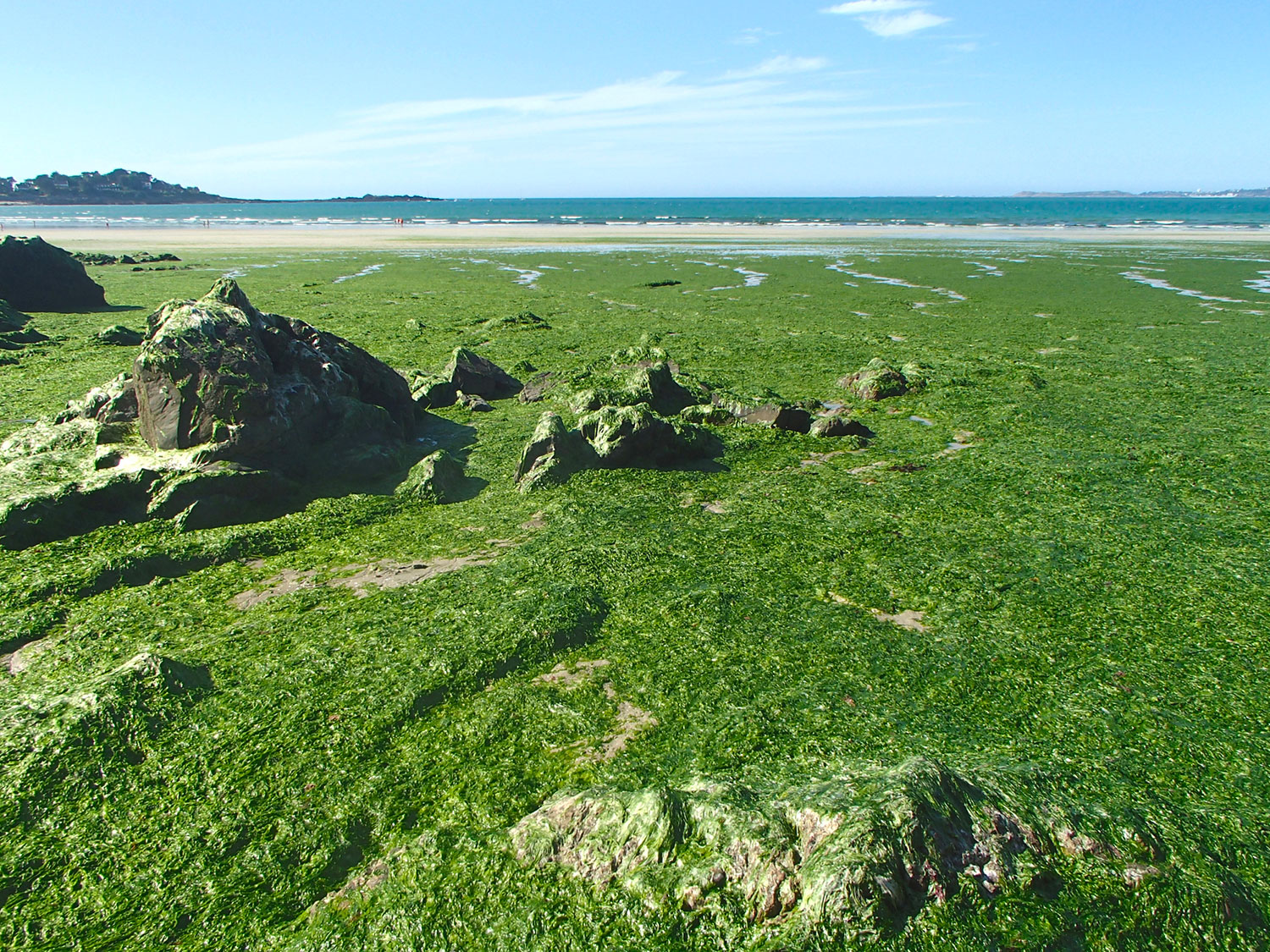 ▲ Massive stranding of green algae on the Brittany coast. © Getty Images |
The factors influencing algal production are primarily the temperature and pH of seawater, sunlight exposure, and nutrient inputs from catchment areas via soil leaching. Changes in the condition of the receiving environment are directly influenced by climate change (heatwaves, acidification of the marine environment, changes in phytoplankton taxonomy, etc.).
🛰️ Current and past satellite missions enable us to estimate certain relevant environmental parameters in coastal waters and to assess changes in land use within catchment areas (thereby gathering knowledge on both long-term (climate) and short-term (human pressure) factors underlying these ‘green tides’). Numerous in situ measurements are carried out on land and at sea to supplement the information obtained via satellite.
Objective
Led by ACRI-IN (maritime and coastal engineering) and ACRI-ST (satellite Earth observation), the primary objective of SAGA (Système d’Anticipation et de Gestion des échouages d’Algues vertes) is to create a coherent database incorporating parameters derived from space-based observation, thereby establishing a digital twin of the green algae phenomenon. This database will be used to highlight i) the consistency between the data and an understanding of their uncertainty, ii) an analysis of the processes linking these parameters (using a combination of statistical methods and AI), and thus gain a better understanding to anticipate green tides and address them.
Methodology
For coastal water quality, spatialised information is estimated from medium- and high-resolution satellite data (Sentinel-3 OLCI and Sentinel-2 MSI respectively) by applying algorithms from the Copernicus Marine Service (CMS) commonly used by ACRI-ST. The parameters are chlorophyll-a (OC5/NIR), suspended organic matter (SOM) measurements, transparency and Phytoplankton Functional Types (PFT). Additional parameters such as sea surface temperature (SST) and salinity will be extracted from CMS. Time series spanning approximately 10 years will enable the analysis of trends contributing to seaweed stranding events. The algorithms will be validated using the aforementioned in situ measurements.
Green algae cover on the foreshore will be estimated using high-resolution (Sentinel-2) and very high-resolution (PlanetScope, 3m) imagery, by combining vegetation indices and AI, as has already been done by ACRI-ST (as part of the Interreg RanTRans project).
Meteorological data, river flow rates and the condition of agricultural plots (NDVI from Sentinel-2, crop type) will be incorporated into the database. A statistical model will establish a relationship between these parameters and nutrients, chlorophyll-a content and beaching data. The deterministic model developed by ACRI-IN for the Léon Trégor SAGE and the AN DOUR public water service will be used to assess the link between pressures and uses.
The creation of a digital twin will begin with the compilation of a database incorporating the various sources. A preliminary analysis is required and will be carried out with the scientists participating in SAGA to define ‘coherent’ zones for which it is feasible to aggregate the data collected from each of them. This reduces the scope of the problem to the creation of time series (virtual buoys). These will also be analysed using an LSTM model to link them to temporal data on the appearance and disappearance of green algae. Once the model has been trained and validated, it will be used to produce bulletins distributed to professionals.
Application site(s)
France:
Brittany: Léon Trégor SAGE (Schéma d'Aménagement et de Gestion de l'Eau, Water Development and Management Plan) area
- Ille-et-Vilaine: Rance Valley
Data
Satellite
Sentinel-2 and Sentinel-3 + PlanetScope for monitoring water body quality, algal blooms and suspicious points/discharges on land
- Copernicus satellite products for sea surface temperature
Other
- Aerial surveys:
images captured by the Roscoff station using a drone (recent flyover of the foreshore),
- images produced by CEVA as part of the green algae monitoring programme since 2002.
- In situ and/or reanalysis data:
ERA5 Land and SYNOP data from Météo-France for rainfall
river monitoring data from An Dour for nutrient salt concentrations in catchment areas
SOMLIT / REPHY stations, for nutrient salts and phytoplankton at sea
SHOM tide gauge, for sea levels
flood warning data and SYNOP data for river flows and rainfall
- agricultural data
- Modelled data:
numerical simulations of salinity, rainfall and wind available from Copernicus
discharge data from the Sinfem model
- the hydrodynamic model of the area, providing very high-resolution current fields
Results – FInal product(s)
Two web portals will be created during the project:
- a web page describing SAGA for communication and stakeholder engagement purposes.
- a service portal enabling users to view data from ‘virtual buoys’ and maps showing changes (invasion/recession) in the surface area of the affected zones. The AI system will enable the dissemination of indicators (initially on a weekly or monthly basis) regarding the likelihood of green tide arrivals or retreats and the risks of stranding (along with a quality index for this forecast).
👉 This portal will enable users to provide feedback to highlight consistencies, inconsistencies or socio-economic consequences for their activities. Once a certain level of confidence in the projections has been established, IPCC scenarios can then be applied.
The database contains all the data used by the project and will be freely accessible or available under licence, depending on the organisations that have made their data available to SAGA. It is a dynamic database that is continuously updated as new data becomes available.
At the end of the project, a technical summary report will be produced in collaboration with the scientific partners and shared with stakeholders within the ILICO network (coastal and littoral research infrastructure), as well as others for whom ACRI-ST is a member of the ‘Stakeholders’ Committee’, in order to promote the contribution of satellite data as a complement to field data.
Finally, the PreviDour platform developed by ACRI-IN and ACRI-ST for the Morlaix region (mapping the impacts of sewage discharges on the marine environment) may be used to relay indicators deemed relevant to local authorities.
Related project(s)
Non-SCO projects
Léon Trégor Coastal Water Vulnerability Profile
SCO projects
On the topic of algae:
- 🇳🇴 SCO HABHB: Early warning system for harmful algal blooms with high biomass affecting fish farming in Norway
- 🇬🇧 SCO SEA-SMART: Monitoring of coastal ecosystems to support sustainable algae and kelp cultivation in South Africa
- 🇸🇪 SCO SwedCoast-BlueCarb: Blue carbon mapping (seagrasses and macroalgae) in Sweden
- 🇫🇷 SCO SeSaM and 🇲🇨 SCO BESS: Monitoring of Sargassum algae