

Sat4BDNB

Satellite Data for the French National Building Database
Project completedThe Sat4BDNB project quantified the urban heat island effect at the scale of metropolitan France and derived 4 decision-support indicators related to urban overheating:
● Mitigation strategy index
● Investment cost index
● Mitigation effectiveness index
● Heat vulnerability index
The data are freely accessible in the French national buildings database BDNB (from spring 2025) and from today on data.gouv.fr.
Overview
The CSTB, french scientific and technical center for the building industry, has built the National Building Database (BDNB) which includes the identity card of 32 million residential and commercial buildings in metropolitan France. This identity card includes, among other things, the morphology or arrangement of buildings in relation to each other, the materials used and technical equipment, energy consumption and data from energy performance diagnostics.
The project used this National Buildings Database (BDNB) and spatial data derived from satellite images to provide robust indicators related to local climate change at the community level (Figure 1).
The indicators are represented by the maximum intensity of the UHI (urban heat island) and the potential vulnerability (heat stress) of citizens. In addition, the assessment of urban adaptation strategies is considered as a complementary support to attenuate the UHI effect.
The integration of the proposed indicators into the NBDB will allow stakeholders to prioritize their planning projects along three main axes:
- the respective building stock and energy performance,
- urban microclimate conditions and the risk of overheating,
- the risk of vulnerability due to heat stress for citizens.

Figure 1: General description of the Sat4BDNB project.
Application site(s)
Mainland France
Data
Satellite
- Sentinel-2: Albedo calculation
- Pléiades: vegetation in the city
Other
- BDNB: Energy performance diagnosis (DPE)
- INSEE: distribution of the population according to age
- IGN: spatial division of cities
- MEREEN: Weather data
Results – Final products
2 products
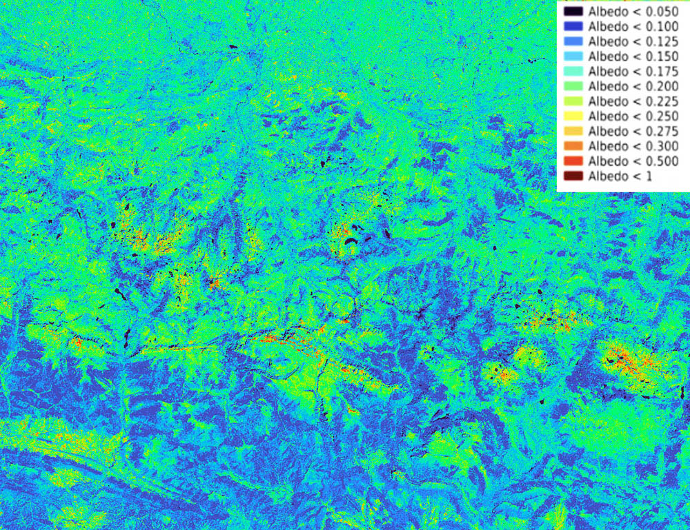
▶︎ Sentinel-2 albedo over part of the Pyrenees. © CNES |
|
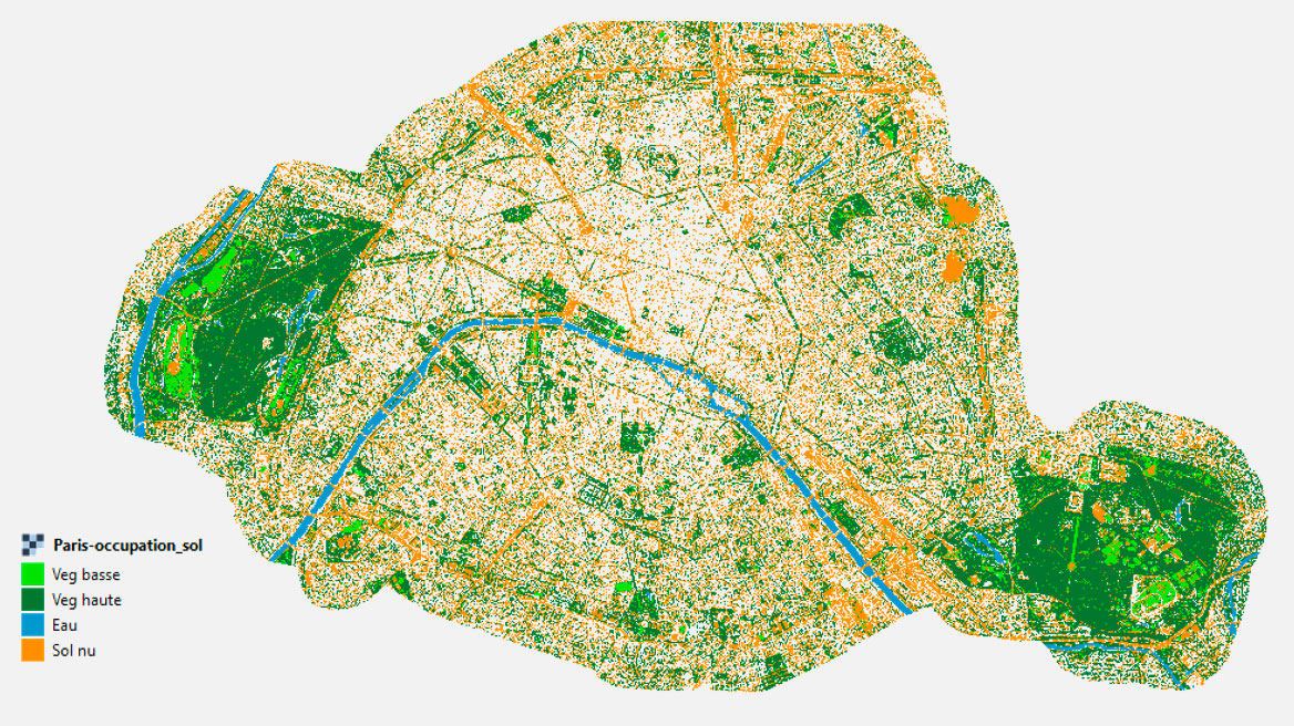
👉 5 cities were produced using Very High Resolution (VHR) images, enabling us to distinguish the smallest vegetated areas, such as gardens, as well as the height of the vegetation, information that is particularly useful for modelling urban climate and simulating development. |
▲ Extraction of vegetation in Paris from VHR imagery. © CNES |
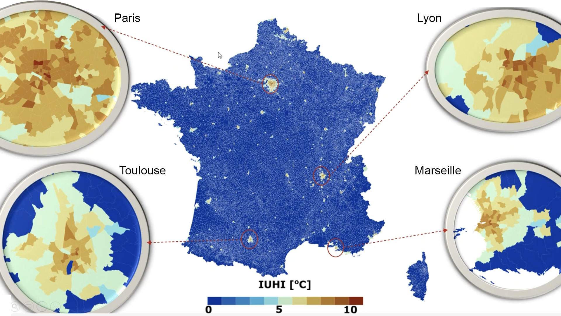
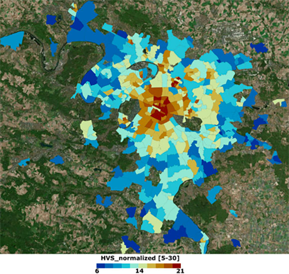
5 indicators linked to the urban heat island (UHI) integrated into the French National Buildings Database (BDNB)
Taking into account all the parameters that influence the generation of the global UHI phenomenon: meteorological variables, city characteristics, including albedo and land use (vegetation), anthropogenic heat, including population density, city canyon characteristics (building height, street width, canyon orientation, city irregularity). |
▲ UHI intensity indicator in 4 major French cities. © CSTB |
The project focused on the implementation of key strategies based on revegetating urban areas and increasing urban albedo, which, according to existing literature, offer the greatest potential for UHI mitigation. The results of the calculations therefore provide a mitigation score. |
Based on the previous index calculations, this index enables us to estimate the investment cost on the basis of a price per square meter (€/m²). |
|
|
|
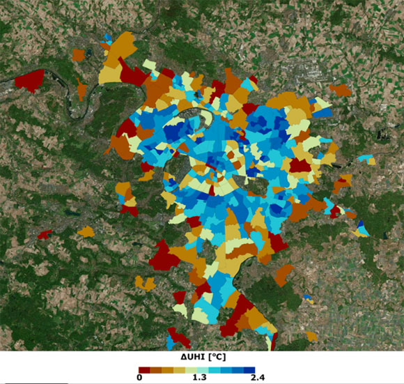
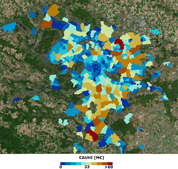
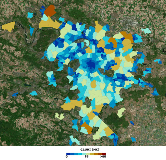
▲ Vegetation-based adaptation strategy indicator (left): maximum potential mitigation capacity of 2.4°C. Associated cost (right): €8 to 14 million in the city center. © CSTB
|
|
|
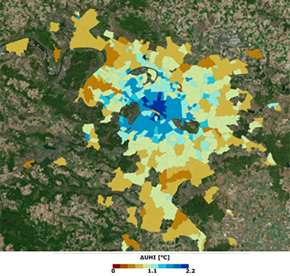
▲ Albedo-based adaptation strategy indicator (left): maximum potential mitigation capacity of 2.2°C. Associated cost (right): €4 to €7 million in the city center. © CSTB
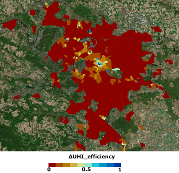
Combining the two previous strategies in relation to the population affected by these urban interventions, this index identifies the neighborhoods where intervention is a priority, and according to which adaptation strategy.
▶︎ Areas to be prioritized are highlighted in blue. © CSTB |
|
Highlighting areas at risk, which are not systematically concentrated within a city's inner perimeter, the indicator reflects the combined effect of population density and type, building energy consumption, green spaces and heat island intensity.
▶︎ Areas at risk for the population appear in brown to red tones. © CSTB |
|
👉 These indicators can be downloaded from data.gouv.fr and, from spring 2025, from the BDNB website.
👉 Full details of these indicators can be found in the End of Study Report, downloadable below in the Resources section.
References
| Sat4BDNB sur GEO Knowledge Hub du Group on Earth Observations (GEO), un référentiel numérique pérenne : https://doi.org/10.60566/ye521-e7h57 |
-
Sangiorgio, V., Fiorito, F. & Santamouris, M. Development of a holistic urban heat island evaluation methodology. Sci Rep 10, 17913 (2020). (Pour le calcul de l’indicateur ICU)
-
Roujean, Jean‐Louis, Marc Leroy, and Pierre‐Yves Deschamps. "A bidirectional reflectance model of the Earth's surface for the correction of remote sensing data." Journal of Geophysical Research: Atmospheres 97.D18 (1992): 20455-20468.
-
Roujean, Jean-Louis, et al. "Surface albedo and toc-r 300 m products from PROBA-V instrument in the framework of Copernicus Global Land Service." Remote Sensing of Environment 215 (2018): 57-73
-
Meta-National Database of Buildings in France. Integration of heat-related indicators of French administrative areas. GE Kyriakodis, R Jean-Louis, L Vincent, S Bertrand, G Thierry, Proceedings of the 6th International Conference on Countermeasures to Urban Heat Islands (IC2UHI), https://www.ic2uhi2023.com/proceedings
-
Atelier THEIA Télédétection pour l’étude du milieu urbain, « Le projet SCO (Space Climate Observatory) Sat4BDNB » B. Saulquin, BS Ingénierie, avec J.-L. Roujean et G. Kyriakodis, 2-3 Fevrier 2023
Related projects
Project News
- 21/01/2025: Sat4BDNB provides keys to tackling urban overheating
- 19/12/2024: Presentation of the Sat4BDNB project at the 15th SCO France Quarterly Meeting "Making the most of high-resolution imaging in the city: flooding and heat islands"
- 26/03/2024: Cities: Sat4BDNB operationalizes albedo production on a national scale