

SCOFrance
Useful linksTAHATAI Project page
🎥Quarterly SCO in the Pacific & Indian Oceans
Key wordsPolynesia, resources, blue economy, anthropic pressures, planning, cloud computing
TAHATAI is operational and continues in Neo version
Preserving the resource and the activity of the blue economy
Seeing the past, the present and the future, this is the credo of the TAHATAI project to achieve better planning of competing uses of the maritime domain in French Polynesia. Shipping, fishing, tourism, pearl farming, food-producing activities... whatever the use, they are all directly impacted by current climate changes, in particular the rise in sea level and temperatures, which introduce modifications to the natural environment.
As Pascal Correia of the Directorate of Marine Resources (DRM), a member of the TAHATAI project consortium as the main user, explains, "To monitor marine resources, to understand everything that can happen in an atoll and the consequences of human activity in these Pacific islands, we need 'fresh' data in near-real time, but it is difficult to cover such a vast area with conventional means.
To meet this need, BLUECHAM, a company specialising in space and cloud computing technologies, has created a system that it has named QVX. According to Rémi Andreoli, BLUECHAM's Director of Spatial Applications, “QVX aims to automate the processing of knowledge on a territorial scale. Thanks to this technology, the system is interoperable and can be connected to various free or commercial data sources. Thus fed and interconnected with the DIAS information and management systems developed in recent years in Europe, this architecture allows us to offer our services in the form of desktop applications but also smartphones so that decision-makers can "take" the information with them in the field or during meetings”.
In accordance with the DRM's requests, the QVX-PF platform (French Polynesia) allows to:
- Capitalize and operating the data
- View historical maps
- Connect, cross-reference, compare and analyse data
- Continuous use of data and indicators in online applications
- Be warned (notifications) of changes or abnormal events such as algal blooms or the presence of boats in a prohibited area.
- Chat online about the results.
3 operational indicators on 2 sites
To develop its system, the BLUECHAM team focused on the high island of Tahiti, capital of French Polynesia, and the Arutua atoll. After recovering existing archive data to establish a reference history of past events, it designed a data cube which, fed with satellite images, compiles and cross-references three main types of data: environmental (weather, climate, water quality), anthropic (urban pressure and human activity in the lagoon environment), and land use planning (land use in the coastal zone, lagoon bathymetry).
Indicator 1 - Water quality
This indicator is applied to phytoplankton blooms that can affect the state of lagoons and the quality of the pearls produced there. Unpredictable and sometimes very localized, these events are difficult to study. Thanks to satellite images relocated to the Takaroa area where a bloom was discovered during a field mission, QVX-PF was able to reconstruct the kinetics of the event, i.e. where and when it started and how it evolved. Thanks to this, an alert threshold on the chlorophyll A level was defined, which will enable the DRM to reinforce its in situ network and to better study blooms in lagoons.
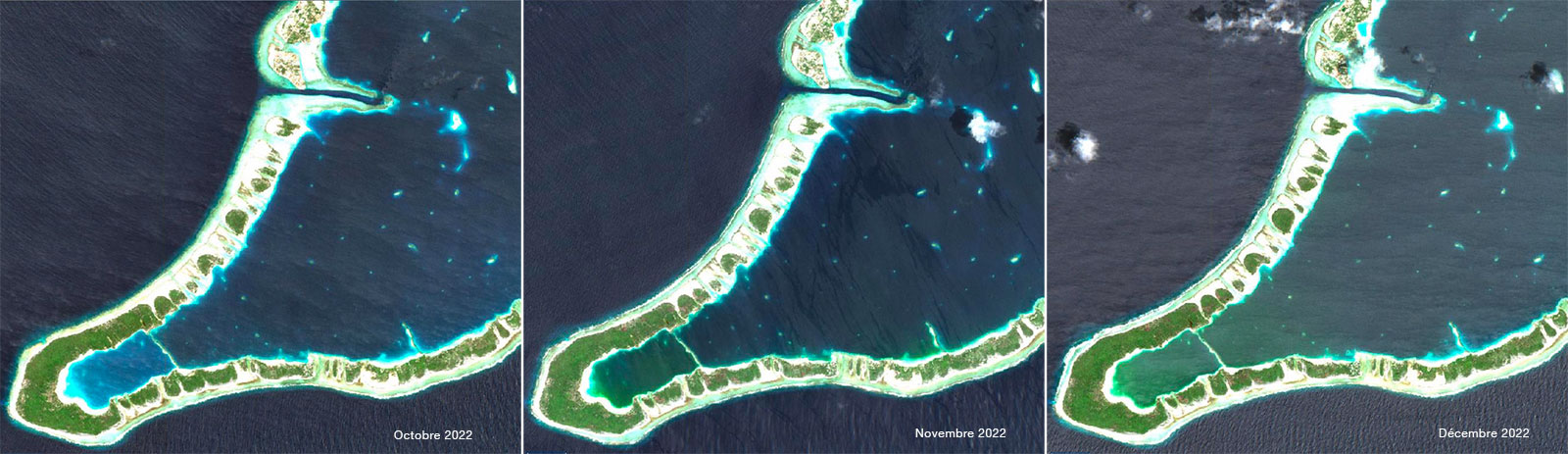
Satellite images have allowed the reconstruction of the kinetics of the phytoplankton bloom discovered by chance in November 2022 at Takaroa. © BLUECHAM SAS/Contains Sentinel-2 modified data
Indicator 2 - Anthropogenic pressures in the lagoon environment
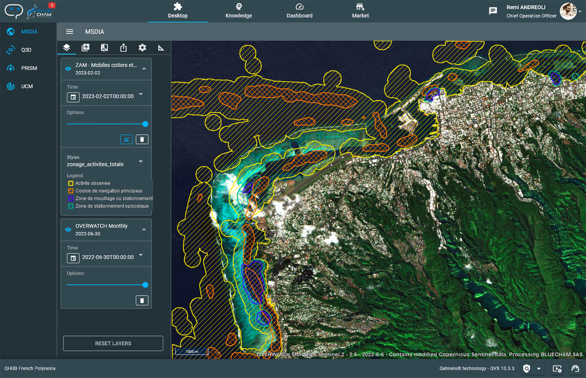
While current monitoring systems focus on illegal activities and maritime traffic around the atolls, the dynamics of local uses within the islands are poorly understood. Using Sentinel-2 imagery and neural network learning, QVX-PF automatically detects boats and generates density maps that highlight traffic corridors and usage zones within the lagoons, complementing the available offshore information.
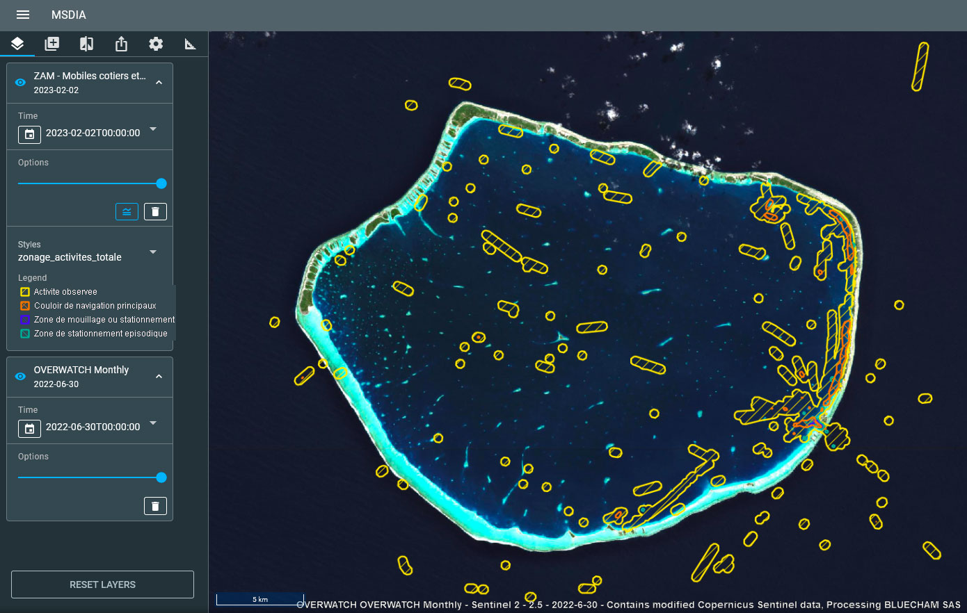
Automatic detection of mobiles (boats) in and around Arutua with the main shipping lanes in orange. © BLUECHAM SAS
Indicator 3 - Anthropogenic pressures on the coastline
To optimize its spatial planning, the DRM needs to characterize the issues and pressures of human activities on the coast with usable and automatable indicators such as the monitoring of embankments and the rate of construction on the maritime domain.
For this purpose, QVX-PF uses Pleiades VHR images from which it derives 9 land use classes: anthropogenic structures, vegetation, water, lagoon, open ocean, lagoon, bare soil.
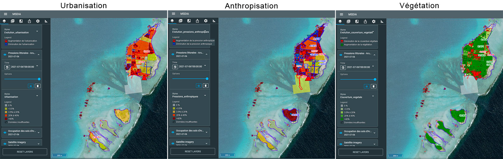
QVX-PF analyses the data to visualise the evolution of anthropogenic pressures. © BLUECHAM SAS
Based on its excellent results, the team will particularly improve the dashboard of indicators and their automation. Eventually, the interface will offer a true digital twin of the islands.
Data, indicators and results are detailed in the TAHATAI project page
An innovative business model
With the particularity of calling on the proliferation of private data emanating from NewSpace, BLUECHAM is already marketing its apps for an astonishing currency: QT or "QVX tokens", whose price includes and simplifies all the costs of purchase, subscriptions and user licenses. Access to the platform is via an account and password.
👉Contact pole.operations@bluecham.net.
Scaling up with TAHATAI Neo
With the support of the SCO label granted at the end of March 2023, the TAHATAI Neo component will allow BLUECHAM to deploy the system throughout Polynesia and to the whole range of actors of the blue sea industry. This will be followed by a second change of scale internationally: Vanuatu, Fiji, India, Australia, Reunion Island, Mayotte.