

ADOPT
 on the invasive plant Buddleja davidii (butterfly tree).")
Earth Observation Data Applications for Regional Nature Parks and their Territories
Project completed
Bringing together seven regional nature parks in France, ADOPT has used a LivingLab approach to co-develop indicators that are useful for managing and preserving these areas. Each of the three pilot regional nature parks has its own results visualisation tool, which can be accessed via a single website.
OVERVIEW
ADOPT (Applications of Earth Observation Data for Regional Nature Parks and their Territories) aims to support the work of Regional Nature Parks (NRP) and their partners by using remote sensing resources to monitor and evaluate the actions planned in their charters, provide indicators of the impacts of changes, particularly climate change, and develop adaptation scenarios.
France has 56 Regional Nature Parks which, grouped together in the Federation of Regional Nature Parks of France, fulfill five missions defined by article R333-1 of the Environmental Code:
- the protection and management of natural, cultural and landscape heritage,
- land use planning,
- economic and social development,
- reception, education and information,
- experimentation, innovation.
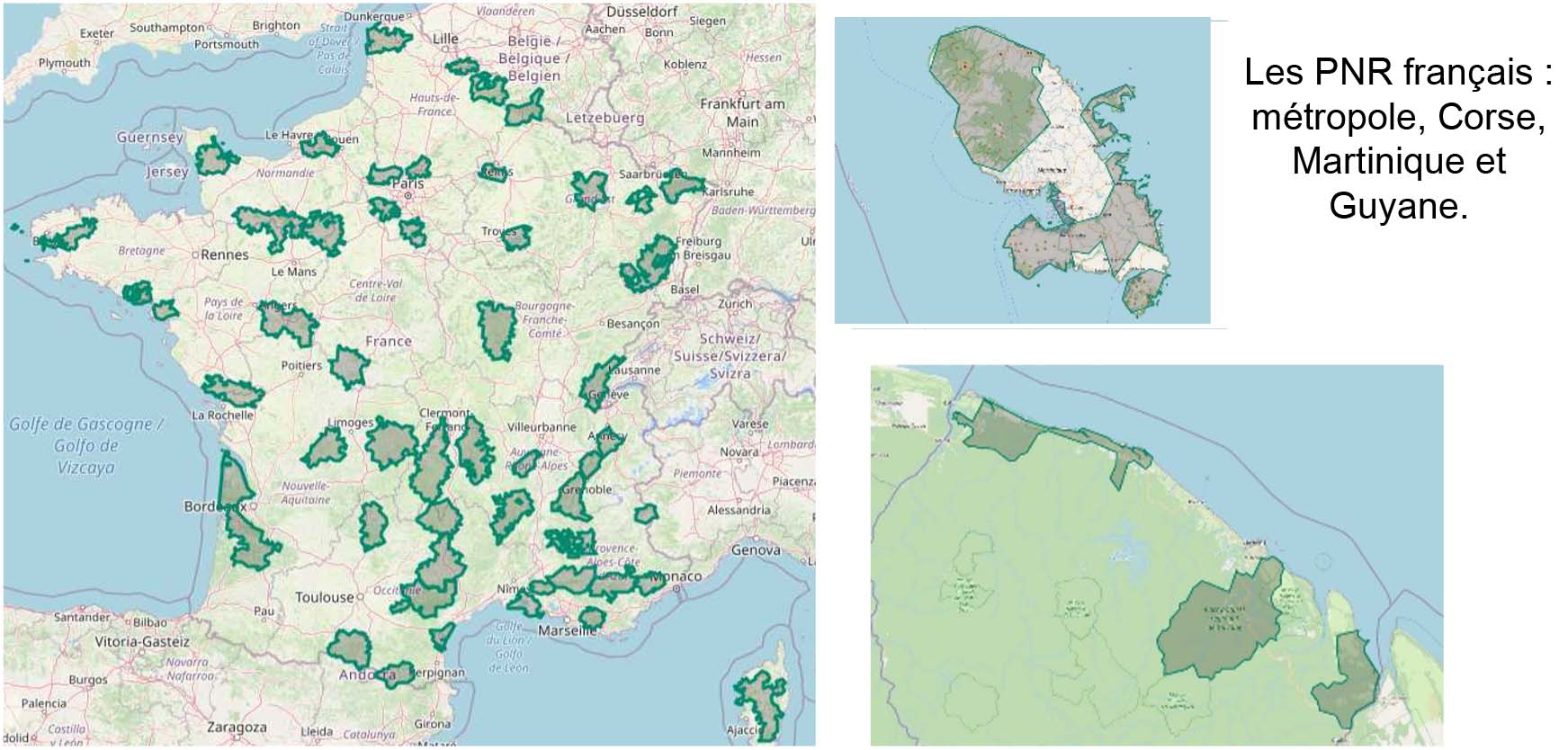
Representing 15.5% of the surface area of France and 6% of its population, the NRP's vocation is to establish economic and social development of the territory, while preserving and enhancing the natural, cultural and landscape heritage. The richness of the Parks lies in the transversality they demonstrate, by integrating biodiversity issues into their territorial projects. © PNR
As true territories of experimentation, the NRP implement innovative policies and are committed to anticipating the effects of climate change on these remarkable heritages. This commitment is reflected in the NRP charters, which specify the objectives and actions of each partner (including elected officials) over a 15-year period, including the necessary monitoring and evaluation mechanisms (Article R333-3). The diagnosis of the territories concerned is a major element of this monitoring and evaluation process and ultimately of continuous improvement.
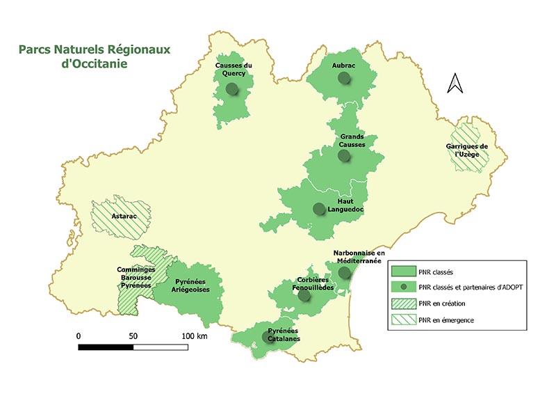
In order to develop products and services adapted to the needs, the Adopt project brought together three cooperative and participative companies (SCOP) specialized in remote sensing, geomatics and implementation of Living Labs as well as the 9 NRP of the Occitanie region. The latter present a great diversity of environments, from the Mediterranean lagoons of the Narbonnaise to the Arcouzan glacier, favourable to the subsequent generalization of the project results.
ADOPT fits into the framework provided by the NRP Charters, some of which are currently being revised or will be in the near future. For this purpose, a co-construction approach to indicators and services in LivingLab mode was favored, involving the NRP and their stakeholders (members of the Development Councils, Scientific Councils, etc.).
Methodology
- The workshops conducting during the first year identified, in an iterative way, the subjects and indicators for which spatial data provide real added value under realistic and acceptable implementation conditions and, if possible, of general interest. It is not only a question of collecting data and producing indicators, it is also important to work on their interpretation and analysis in order to be able to formulate hypotheses on impacts or adaptation policies.
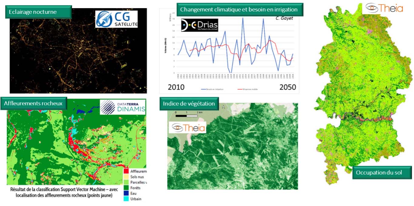
Example of products that can be used in the process of co-construction of indicators of change impacts. © LaTeleScop/E2L/CESBIO/Theia
- The second year of the project focused on testing the design of the selected indicators. This stage aimed to mobilize all partner regional nature parks by forming a community of professionals trained in the use of satellite resources, defining an operational demonstrator, and evaluating hypotheses with a view to developing future areas of work.
APPLICATION SITE(S)
The Occitanie region was chosen because of the geographical locations of the structures involved, the knowledge of the actors and the diversity of the environments. The 7 classified NRP and the two NRP in creation occupy 25% of the surface of the Region and gather 884 municipalities.
DATA
Satellite
Data and products with national coverage distributed by Theia, Dinamis, the CopernicusClimateChange Service (C3S), the USGS and NASA.
Other
- Public databases (maps, statistics...)
- Field surveys
- Model results and climate projections (DRIAS).
RESULTS - FINAL PRODUCTS
ADOPT responds to the need of regional natural parks to objectively assess the potential impact of climate change on their territories in order to help define adaptation policies. The momentum generated by ADOPT is reflected in a website. This platform is designed as a tool to facilitate future initiatives aimed at extending the potential uses of space-based remote sensing.
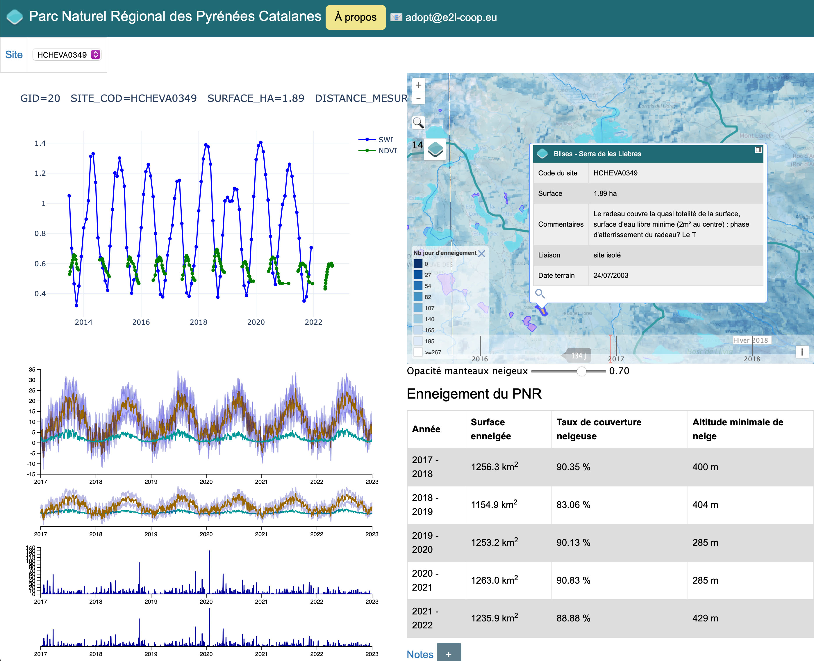
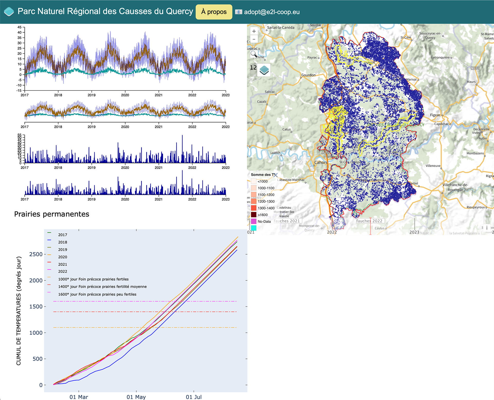
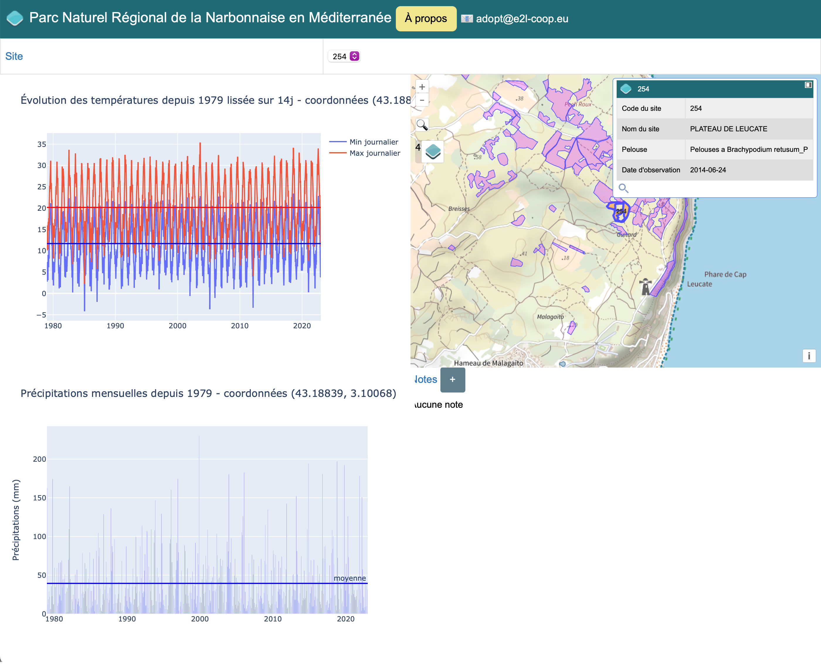
Each of the three pilot NRPs has an ‘Innogis’ interface that allows them to view remote sensing indicators based on the hypotheses developed during the collaborative workshops. Each interface allows users to:
- Select an area of their choice
- Study variations in remote sensing and weather data over time
- Zoom in on a specific period to study remote sensing data correlated with weather information.
In line with SCO's general philosophy, these open-source WebGIS interfaces provide free access to the project results.
|
👉 Innogis PNR Pyrénées Catalanes : snow cover
|
👉 Innogis PNR Causses du Quercy : permanent grasslands
|
👉 Innogis PNR Narbonnaise en Méditerranée : semi-natural coastal habitats
|
Related project(s)
SCO ORION for snowpack, climate, and mountain approach
Project News
-
30/09/2022: Presentation of the ADOPT project and its progress at the 6th Quarterly Meeting of the SCO France on the theme Monitoring the evolution of natural areas by remote sensing
-
30/06/2022: ADOPT: at the heart of regional nature parks
- 04/03/2022 : ADOPT: full speed ahead!
Newsletter ADOPT (in French):
- Newsletter n°4 - 15/06/2022
- Newsletter n°3 - 07/10/2022
- Newsletter n°2 - 31/07/2022
- Newsletter n°1 - 30/06/2022