

SCOFrance
PartenerDDTM Aude (11), ONF, SDIS Aude, INRAE, Météo-France, CNES
Useful linksProject page
KeywordsFires, fire risk, vegetation, wasteland, squatting, drought, prevention, awareness
Aleofeu: a fire risk map and a prevention video
|
Based on the map produced as part of the ALEOFEU project, the DDTM (Departmental Directorate for Territories and the Environment) of the Aude department has produced this prevention video, which is also available on the Aude Prefecture website. |
|
Already a partner in the SCO FLAude project on flood risk prevention, in 2022 the DDTM of Aude renewed its request for SCO support to carry out similar work on fire risk with the ALEOFEU project. As Julia Pineda, head of the Forest, Hunting and Biodiversity Unit at DDTM11, points out, "While the Aude department has historically been severely affected by flooding, with some dramatic events, we do not have a culture of forest fire risk. However, this level of risk is increasing exponentially with climate change, but also due to a farming sector in serious distress, with the abandonment of activities and the consequent development of wasteland, a major source of fires."
|
|
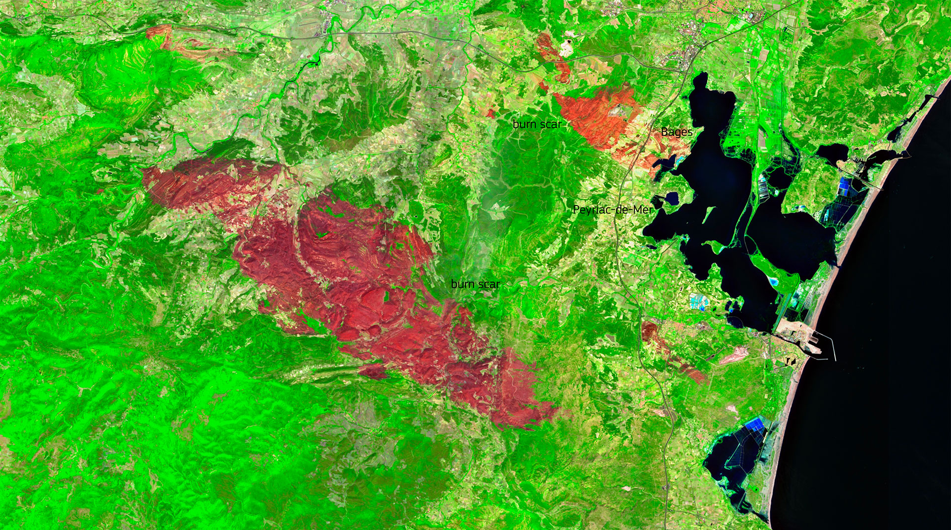
The exceptionally hot summer of 2025 unfortunately confirmed these fears with several fires in the department, including one that started on August 5, 2025, leaving a terrible scar of nearly 17,000 hectares, an area larger than Paris. The rapid spread of the fire was exacerbated by drought conditions, dry vegetation, and strong winds. ◀︎ Sentinel-2 image acquired on August 14, 2025, nine days after the fire started. © European Union, Copernicus Sentinel-2 imagery |
Primary objective: to improve risk awareness and disseminate information
In a windy department with forests that have a significant shrub layer not detailed in existing databases, as well as fields that are becoming wasteland and a significant phenomenon of cabanisation (undeclared buildings), the Aude cannot be satisfied with a general map that is insufficiently detailed. And for prevention to be effective, this knowledge must be shared: with local decision-makers, to inform them of the varying consequences of certain land-use plans on the risk, and with the population, who are directly affected. In addition to the map, the DDTM11 produced the video at the beginning of this article to raise general awareness.
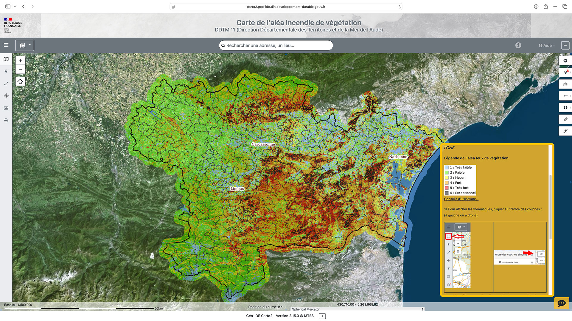
👉 Freely accessible online, anyone can consult the vegetation fire hazard map generated by the project. As Julia Pineda points out, "For the inhabitants of the Aude, it is an opportunity to see the level of risk in their living environment. This map is also of interest in terms of regulations, for example in relation to new brush clearing requirements. Its accuracy should make it of interest to other departments around the Mediterranean, and probably others in the future, as the risk of forest fires is increasing and moving northwards."
🖱️ Consult the vegetation fire hazard map
To fully understand the value of this map, let's take a quick look behind the scenes of the project.
Satellite data to build the fire hazard map
The amount of combustible material, i.e. vegetation, is the key factor and the challenge to be overcome in order to refine any estimate of fire risk, and this is information that satellites can provide accurately.
As a partner in the project, CNES's Lab'OT provided very high-resolution image processing algorithms (Pléiades) to generate maps showing changes in vegetation health and detecting illegal cabanisation. When combined with the location of agricultural plots, vineyards, and illegal settlements, vegetation masks make it possible to identify high-risk areas and visualize how they are changing. These products improve the reference forest fire hazard map produced by the ONF-DFCI, which combines the amount of combustible material present (i.e., vegetation) with wind, sunlight, and slope factors to determine how a fire will spread.
Ultimately, this vegetation fire hazard map is based on vegetation cover, fire spread conditions, and weather. Vegetation fires are modeled according to flame front power and historical fires during the summer season.
Focus on the probability of occurrence and vegetation behavior
Lab'OT also provided 22 years of Sentinel-2 and MODIS satellite data to INRAE to assess the contribution of optical remote sensing data to complement meteorological and/or landscape variables in fire prediction models.
From this satellite data, INRAE has created indicators to improve the probabilistic prediction of forest fires (in number and size) throughout the Prométhée zone (Mediterranean axis). This large satellite database has also been used to model water content in shrubby areas, a crucial factor in fire danger.
These results have thus made it possible to improve short- and long-term fire hazard forecasting by refining hazard classes and creating specific regional models.
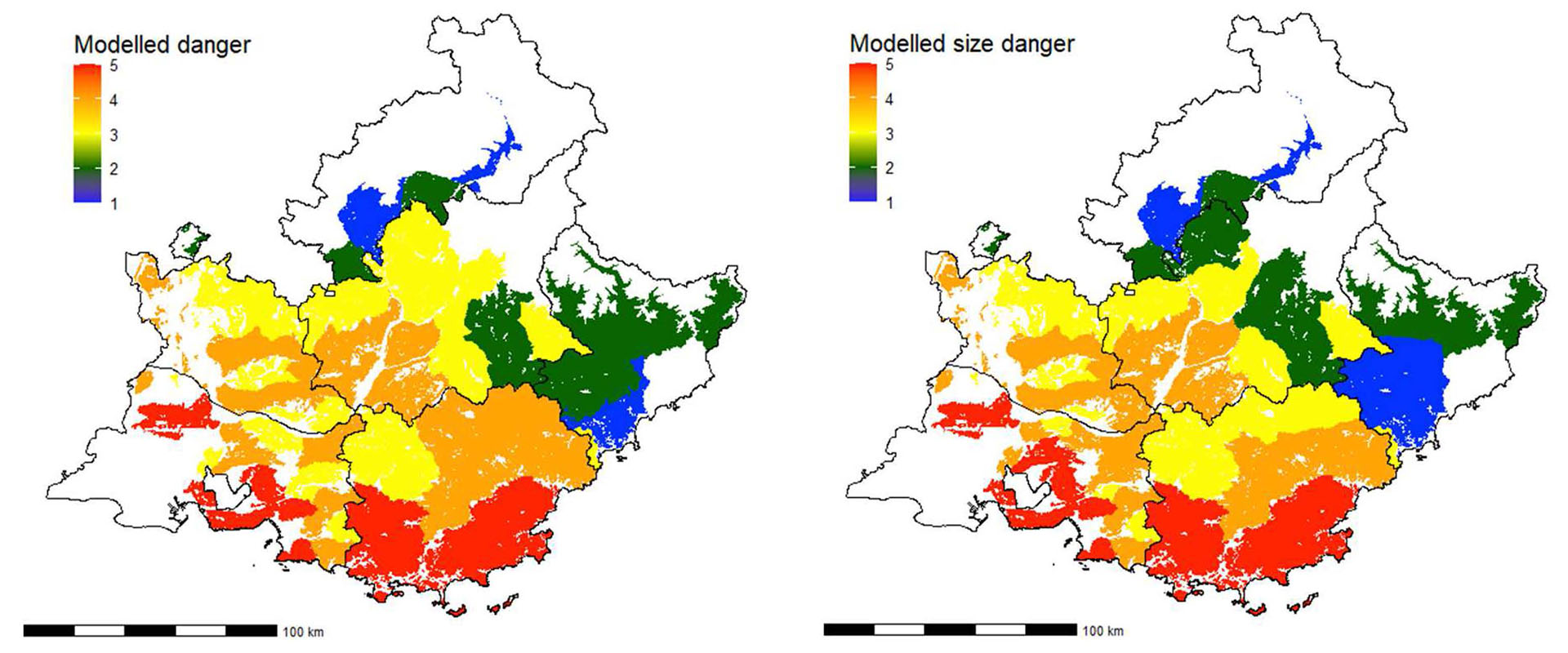
▲ Examples of forecasts of the risk of fires >1 ha (left) and large fires >100 ha (right) based in part on satellite data, applied to "forest fire" areas in southeastern France. © INRAE
Prospect
The ALEOFEU project opens up concrete prospects for regularly updating forest fire hazard mapping by periodically (every year or every two years) replaying the input data. The aim is to have an operational tool that can dynamically recalculate this hazard based on changes in climatic and territorial parameters. The continuation of the project through a new phase would aim to design and implement this automated updating tool, thereby consolidating a sustainable system for anticipating and managing fire risk.