

Band-SOS
")
Bangladesh Delta Floodings: An Integrated Framework for Social Adaptation to Cyclone Surges
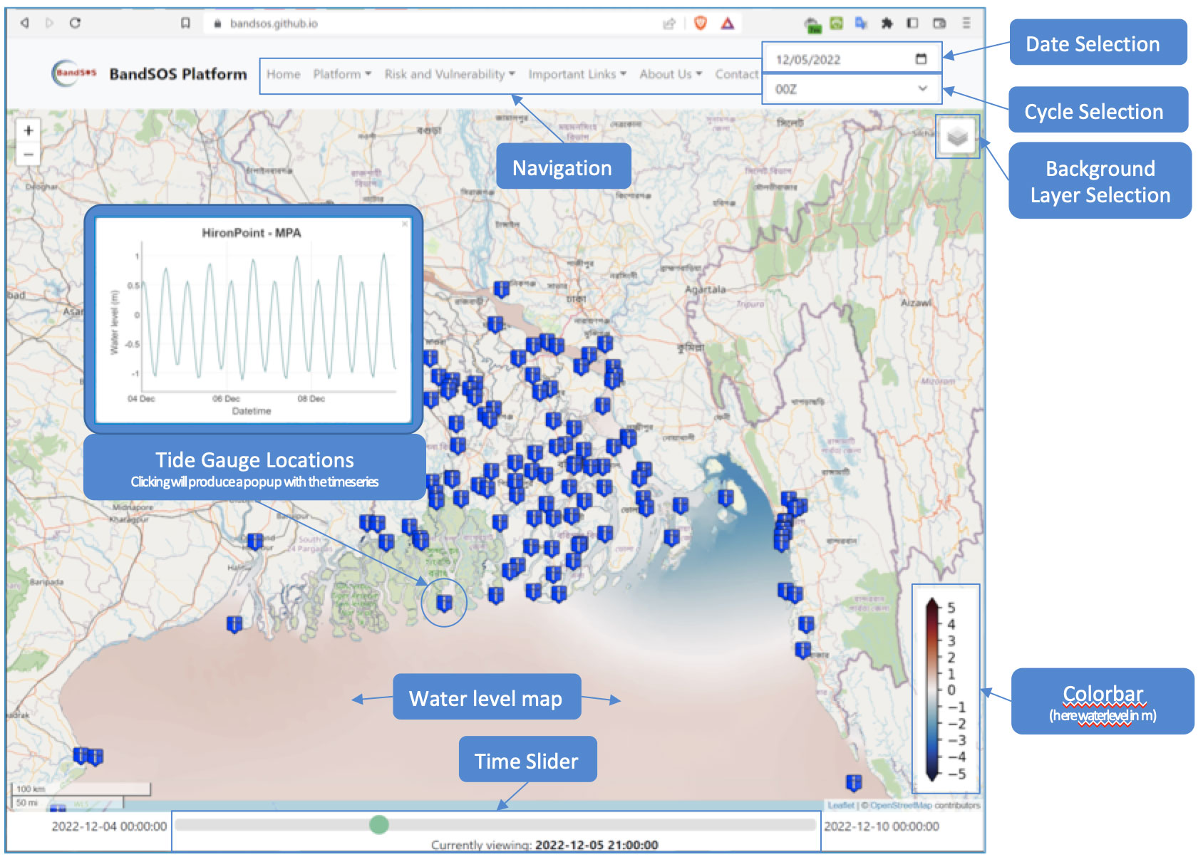
Project completedBanD-SOS has led to the deployment of an operational cyclonic flood forecasting platform covering the Bengal delta. This platform is accessible via an immediately useful web portal, accessible to all users, in real time el (https://bandsos.github.io). The platform was put to the test in real-life conditions during cyclone Remal in May 2024.
OVERVIEW
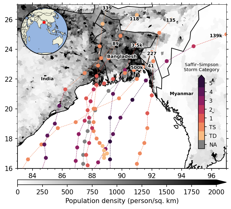
The Bengal delta, straddling Bangladesh and India, is hit by a major tropical cyclone every 3 years on average. Their occurrence is relatively moderate compared to other tropical regions, representing only 5% of global cyclones. The impact of these events is however major, representing 50% of the cyclone victims recorded on the whole globe. This is due to the very low topography of the delta above sea level (less than 5 meters) and the fragility of coastal defense structures, combined with the high density of the vulnerable population (Figure 1).
|
► Figure 1: Trajectories and intensities of major cyclones that have struck the Bengal Delta over the past five decades, with the number of victims recorded for each. The background map represents the population density (inhab/km2). © Jamal Uddin Khan (LIENSs, La Rochelle). |
 |
The exposure of the Bengal delta to cyclonic flooding is increasing in the current context of sea level rise due to climate change. The objective of the BanD-SOS project was to develop a pre-operational flood forecasting system, whose function is to:
- provide in real time the basic information necessary for the implementation of evacuation and protection operations when a hurricane event occurs,
- Assist in the development of public policies for adaptation to the flood hazard necessary to ensure the resilience of the Delta population in the medium to long term.
To this end, the BanD-SOS service consisted in pre-operationalizing a numerical forecasting platform for cyclonic flooding over Bengal, for which we have completed the proof-of-concept (Khan et al., 2021). The BanD-SOS service ensures the prediction of the flood hazard, combined with spatialized information of the socio-spatial vulnerability of the exposed territories.
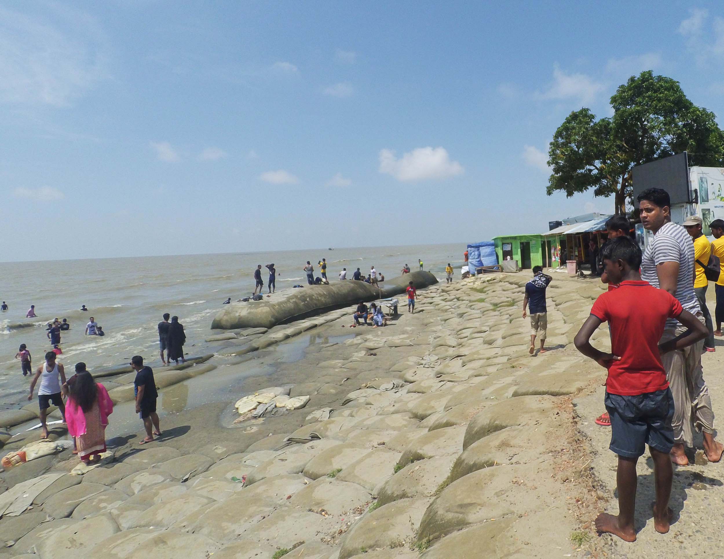 |
◀︎Coastal defenses installed along the coastline of Kuakata (South Bangladesh) ©Jamal Uddin Khan (LIENSs, La Rochelle). |
The main user of the first operational service available is the Bangladesh Flood Forecasting and Warning Center (FFWC). The pre-operational version is based on the database of the Bangladesh Water Development Board (BWDB), a FFWC's parent organization.
👉 The demonstration of the replication of this pre-operational chain will be realized with the porting of the solution on the Amazon Delta.
Methodology
The BandSOS platform uses the SCHISM hydrodynamic model, which simulates the evolution of sea level and waves on a scale of a hundred meters over a few minutes. Taking into account the interaction of the tide, the cyclonic effect and river inputs from the mainland, it reproduces sea level variability across the entire river - delta - coastal ocean continuum. It is particularly well suited to capturing the extreme water levels reached at the peak of cyclonic episodes.
Spatial remote sensing is at the heart of the BandSOS system.
Finally, thanks to an archive of high-resolution Sentinel-2 satellite images, the project team has been able to calculate a Digital Elevation Model (DEM) of the area along the coastline between high and low tide, known as the “intertidal zone”. This is a key element of the BandSOS platform, as cyclonic inundation dynamics depend on the topography of the intertidal zone. In particular, flooding reacts very strongly to areas of very wide, gently sloping beaches which, as in the Bengal Delta, are uncovered by several kilometers between high and low tide.
Application site(s)
Bengal Delta (Bangladesh, India)
DATA
Satellite
Sentinel-2A and -2B multi-spectral imaging
Other
Bangladesh Bureau of Statistics databases:
- Sample Vital Registration System (SVRS)
- Household Income and Expenditure Surveys (HIES)
RESULTS - FINAL PRODUCTS
The objective of the project was to build a pre-operational production chain for our coastal flooding prediction platform. It can be activated on demand and in real time by non-specialists end users, via the intuitive web interface https://bandsos.github.io. A specificity of this forecasting chain consists in highlighting the risk level of the exposed territories for the end user.
The key points of this interface are as follows:
- developed entirely using open-source technologies
- hosted on github pages
- displays the forecast for the next 14 days
- replay of past events
- results are fully accessible and public
BandSOS application
References
| BandSOS on GEO Knowledge Hub, a long lasting digital repository created by the Group on Earth Observations: https://doi.org/10.60566/g26vd-67k46 |
- Khan, M. J. U., et al. (2020), Towards an efficient storm surge and inundation forecasting system over the Bengal delta: Chasing the super-cyclone Amphan, Nat. Hazards Earth Syst. Sci. Discuss., https://doi.org/10.5194/nhess-21-2523-2021
- Khan, J. U., et al. (2019), High Resolution Intertidal Topography from Sentinel-2 Multi-Spectral Imagery: Synergy between Remote Sensing and Numerical Modelling. Remote Sensing, 11, 2888; doi:10.3390/rs11242888, 2019
Project news
-
01/07/2024: Use case: BandSOS put to the test by Cyclone Remal
-
29/03/2023: Presentation of the BanD-SOS project and its progress at the 8th Quarterly Meeting of the SCO France dedicated to SCOlutions to hydrometeorological risks, including an introduction on the use of satellite data in the different phases of risk management
- 25/04/2022 : BandSOS: a societal necessity, kick-off meeting