


SCOThaïlande
PartnersGISTDA, NASA, ESA, JAXA, CEOS
Keywords
Thailand, forest, carbon storage, carbon credits, forest management


With CarbonAtlas, satellites become the invisible guardians of forest carbon
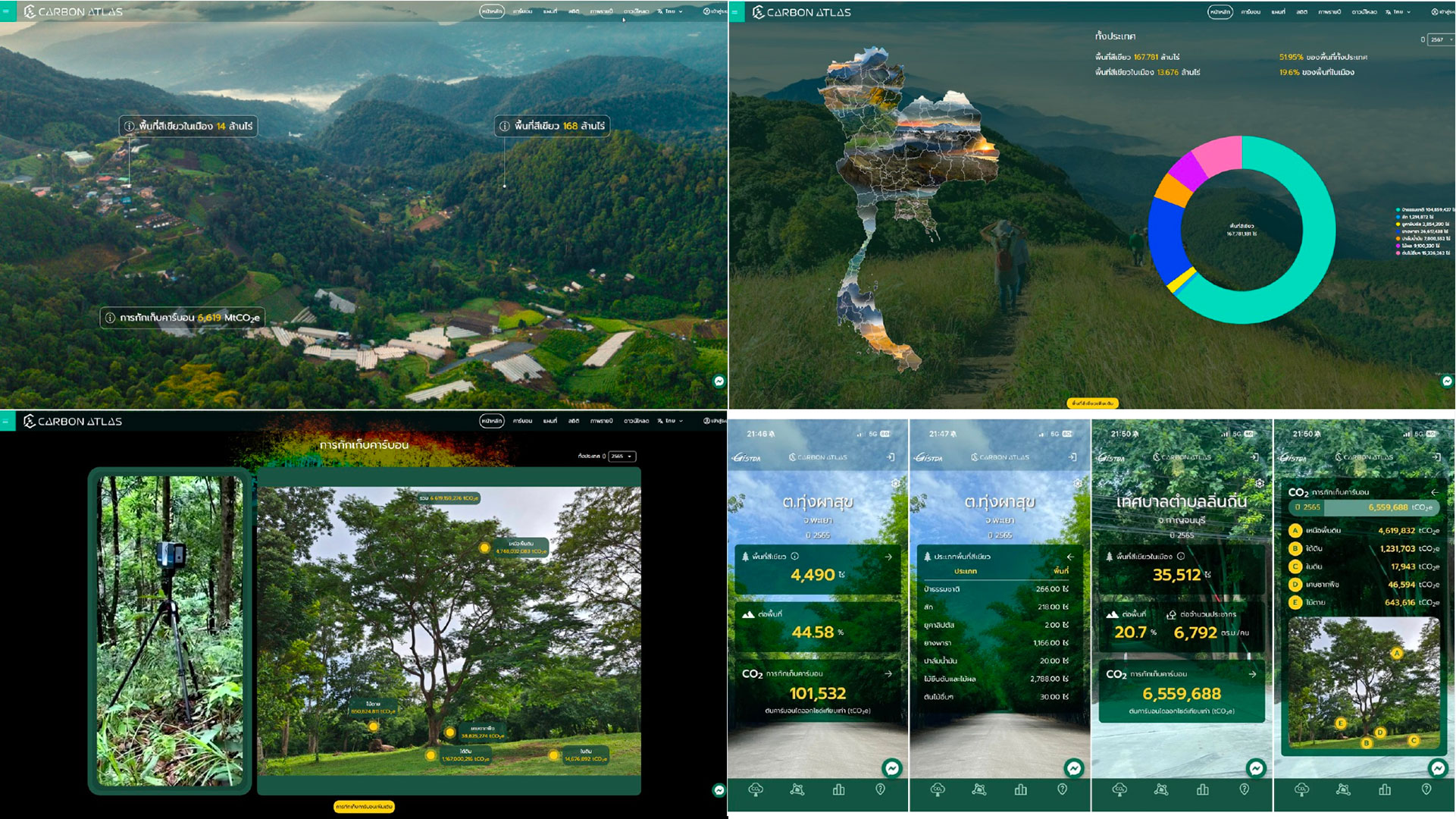
| Offering a truly operational service, CarbonAtlas-THA illustrates the growing role of space technologies in climate policy. Beyond mere maps, it represents a new way of monitoring forests, informing public decision-making and supporting the transition to a low-carbon economy. | 🚨 CarbonAtlas will be presented on November 16, 2026, at the first session of the SCO World Virtual congress. |
How can we prove that a forest actually stores carbon?
Trees naturally absorb some of the carbon dioxide present in the atmosphere, making forests valuable allies in the fight against global warming. However, measuring the carbon they store remains a real challenge. Traditional inventories rely on lengthy and costly field surveys, which are difficult to repeat regularly across millions of hectares.
Yet having reliable data has become essential: to monitor national climate commitments, to better protect ecosystems, to prepare carbon credit projects and to demonstrate their real impact.
CarbonAtlas-THA was developed to meet these needs, shaped by the operational requirements of users in Thailand’s public and private sectors, particularly to support the national voluntary emissions reduction programme (T-VER) and local forest management.
Multiple perspectives to see the invisible carbon
At first glance, a satellite image simply shows an expanse of greenery. But to those in the know, it reveals much more. Optical satellite data help detect vegetation condition, canopy greenness and land-cover type. Radar satellites, meanwhile, capture forest structure – including vegetation density and tree height – as well as moisture-related signals even under cloud cover, which is common in tropical regions. Finally, elevation products describe terrain and canopy structure.
CarbonAtlas-THA supplements this spatial information with field inventories and surveys carried out directly in the forests using laser scanning and 3D drones. More than 1,000 plots scanned in this way provide reference data on the biomass of different types of forest.
All this data is ultimately fed into artificial intelligence models capable of estimating tree biomass – known as above-ground biomass – and the amount of carbon they contain.
► Methodology concept: integrating satellite basemap, green-area classification, forest canopy density, burn-area information, 3D scanning plots and AI to estimate above-ground biomass and uncertainty. © GISTDA | 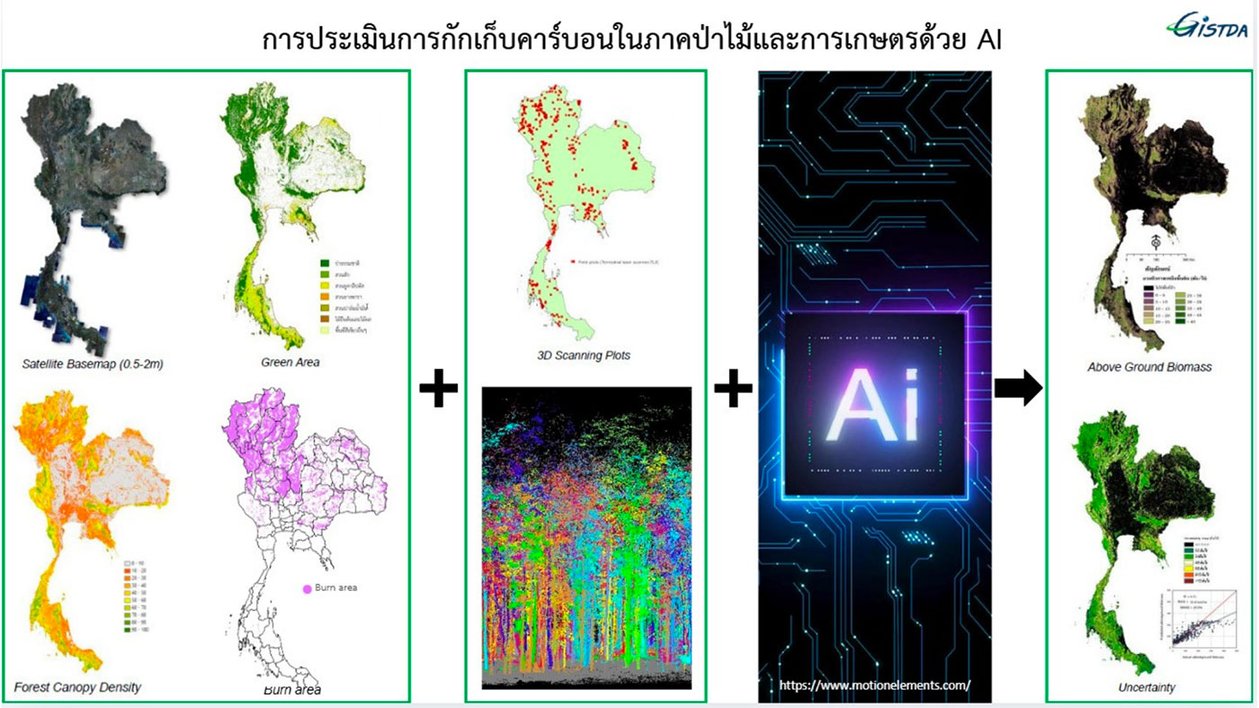 |
A comprehensive carbon atlas
The results are compiled in CarbonAtlas, a public platform and a mobile/web dashboard for Thailand. Freely accessible, it is a Carbon Digital MRV (measurement, reporting and verification) platform. Using an interactive map, users can view carbon stocks, visualize changes in green spaces and download statistics, ranging from the plot level to the whole of Thailand, via districts and sub-districts.
CarbonAtlas distinguishes between natural forests, eucalyptus, rubber, oil palm, fruit trees and other tree cover, and identifies carbon-relevant land-cover classes.
Initial significant findings
For 2024, CarbonAtlas estimates that:
- green areas cover nearly 52 per cent of Thailand’s territory,
- urban green spaces cover 19.6 per cent of urban area,
- which represents approximately 5.51 billion tonnes of CO₂ equivalent of total carbon storage.
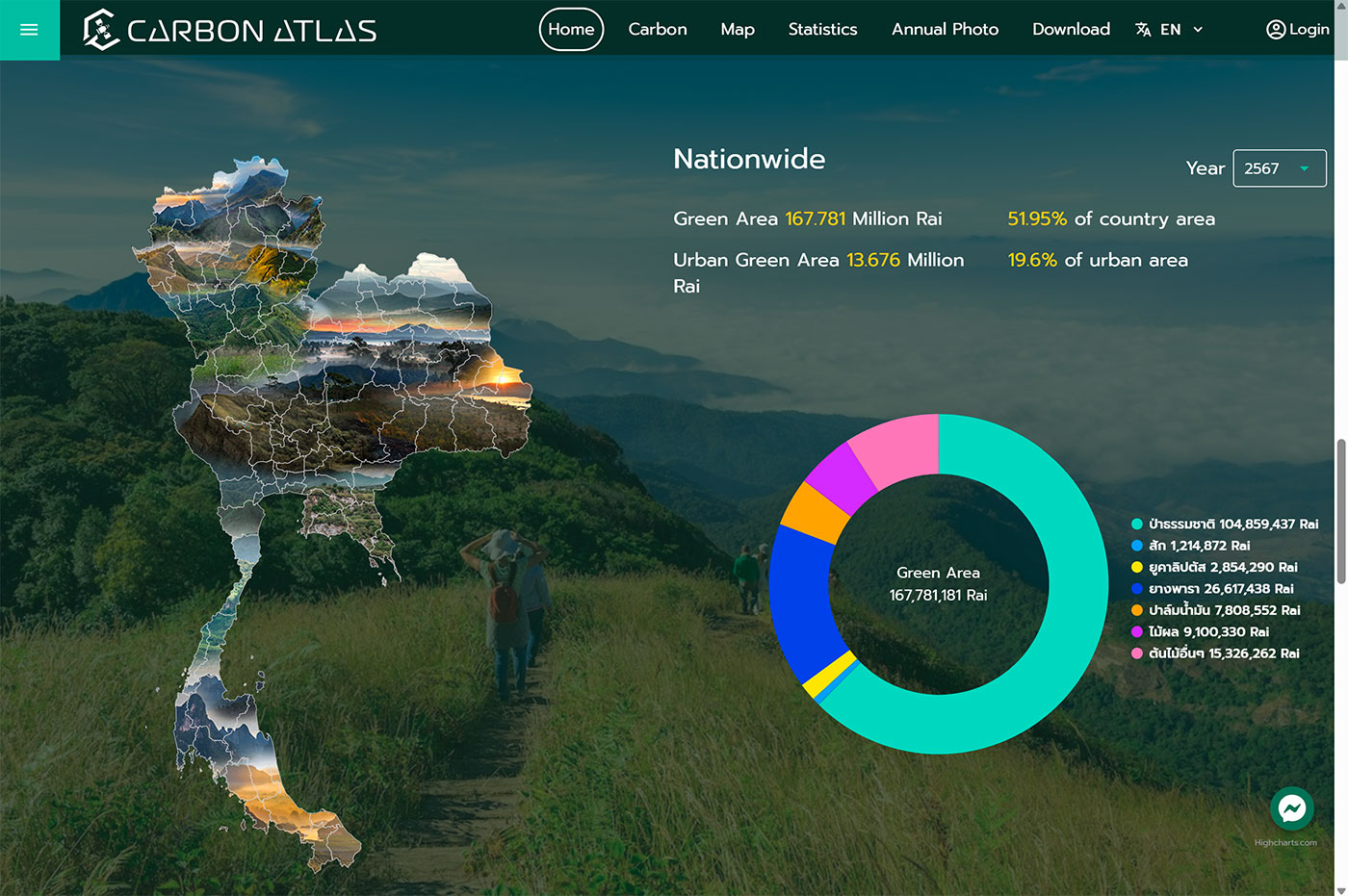 ▲ National statistics on the website's home page. © GISTDA | 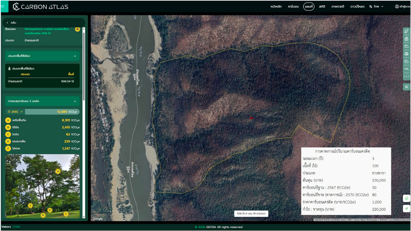 ▲ Example of plot-level Carbon Atlas map: parcel boundary, carbon pools, carbon-credit forecast assumptions and satellite basemap interface. © GISTDA |
Access the CarbonAtlas platform
NB: Whilst many features are freely accessible, for detailed carbon-credit assessment, field-scale services, or T-VER-ready reporting, users should contact GISTDA through official channels, by email or by phone (business and service contact: 0 2141 4652 and 0 2141 4584).
Turning data into evidence and decisions
CarbonAtlas-THA’s innovation lies not only in its technology: its true strength lies in transforming millions of data points into directly actionable insights:
| A partnership spanning space, fieldwork and public policy To ensure the reliability of its results, CarbonAtlas-THA benefits from a consortium of complementary stakeholders, including key end-users.
|
A story that is only just beginning
👥 In Thailand, further collaboration and demand are emerging from the Ministry of Natural Resources and Environment, the LESS/T-VER emission reduction activities linked to the TGO (Thailand Greenhouse Gas Management Organization), PTT (Thailand’s state-owned oil and gas company) in the Wangchan Valley, provincial and academic partners, as well as private sector project developers in rubber, mangrove, natural forest and plantation contexts.
⚙️ Given this level of demand and the tool’s proven potential, the teams wish to strengthen, amongst other things, the following aspects:
- Upgrade from periodic carbon mapping to more frequent MRV services with clearer uncertainty information.
- Expanding the scope to include comprehensive accounting for all five carbon pools (above-ground biomass, below-ground biomass, deadwood, litter and soil organic carbon).
- Support T-VER-ready reporting and carbon-credit feasibility at the project scale.
- Develop 1- to 3-year carbon-credit forecasting models.
- Scale use across government agencies, private restoration projects, community forests, and urban green-space monitoring.
- Set up an English access to the platform and demonstration sites such as the Wangchan Valley and partner-requested areas.
The SCO’s added value
As GISTDA states, ‘The SCO provides international visibility, peer recognition, and a climate-application community for CarbonAtlas-THA. It helps position Thailand’s Carbon Atlas as a space-based climate service, connects the platform to other SCO projects, and supports communication beyond a national audience. This is especially important for demonstrating that Thailand is not only using satellite data but also transforming it into an operational MRV service for climate action.”