

SCOFrance
PartnersUniversity of Rennes, French Polar Institute, CNRS, TAAF, INRAE, UMS Patrinat, CNES
ContentsHabitat typology
Application to Saint Paul Island
A response to environmental challenges
A solution for all sub-Antarctic lands
Useful linksCartovege2 project page
KeywordsSouthern territories, habitats, biodiversity, mapping, conservation
Cartovege2: mapping the unique biodiversity of the sub-Antarctic islands
Cartovege is a project close to our hearts because it brings us back to the essentials: nature, wild and breathtakingly beautiful, our primordial environment without which we cannot live.
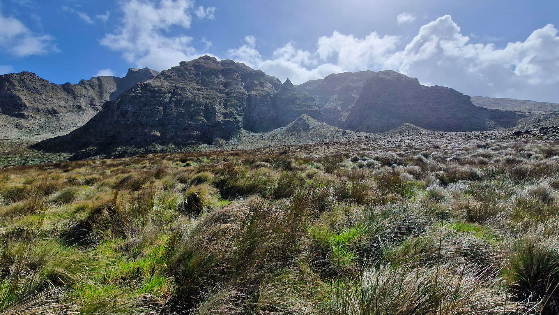
Let’s head to the Roaring Forties, in the French sub-Antarctic islands: after implementing its method for mapping natural habitats on the Crozet Archipelago, the Cartovege team adapted and refined its processing workflow some 2,300 km to the north-east, on the islands of Saint-Paul and Amsterdam. Uninhabited, listed as a UNESCO World Heritage Site and designated a national nature reserve, these islands are home to flora and fauna found nowhere else in the world. | Cartovege is both a rigorous method for defining and classifying habitats specific to the Southern Territories and a workflow for processing field data and multi-source imagery, capable of automatically generating a very high-resolution habitat map – including for unvisited areas – using satellite imagery. We invite you to (re)read the Cartovege2 news item: Mission Amsterdam. |
Diane Espel, a postdoctoral researcher in remote sensing who has thrown herself into the project, both in the field and in terms of the algorithms, sums it up as follows: “Automated and scalable, Cartovege is not merely a monitoring tool: it is a catalyst for ecological research because it is capable of effectively and on a large scale capturing how plant communities reorganize in response to climate change or following a major event such as the Amsterdam fire. Furthermore, by reducing the carbon footprint of scientific expeditions by more than half, this solution paves the way for more responsible science”.
Habitat classification of Amsterdam Island
Developing a habitat typology requires extensive field expertise and is an essential prerequisite for any habitat mapping and modelling.
🌱 Thanks to over 1,000 field surveys combining historical data with observations made during the 2024–2025 summer campaign, the first habitat typology for the island has been established. This unprecedented framework identifies five environments, which are further subdivided into 13 habitats, themselves categorized according to 45 plant and mineral formations.
👉 This work has, in particular, enabled the first precise description of the habitat of the Amsterdam albatross, an endemic species classified as ‘critically endangered’: the peat bog containing the bryophytes Dicranoloma subconfine and/or Racomitrium lanuginosum (class C21, shown in pale pink on the map below).
► Distribution map of Amsterdam Albatross nests (predicted habitat map at the 3rd typological level with a resolution of 50 cm). The red ellipse corresponds to its preferred habitat. © CARTOVEGE² - D. Espel (2026) | 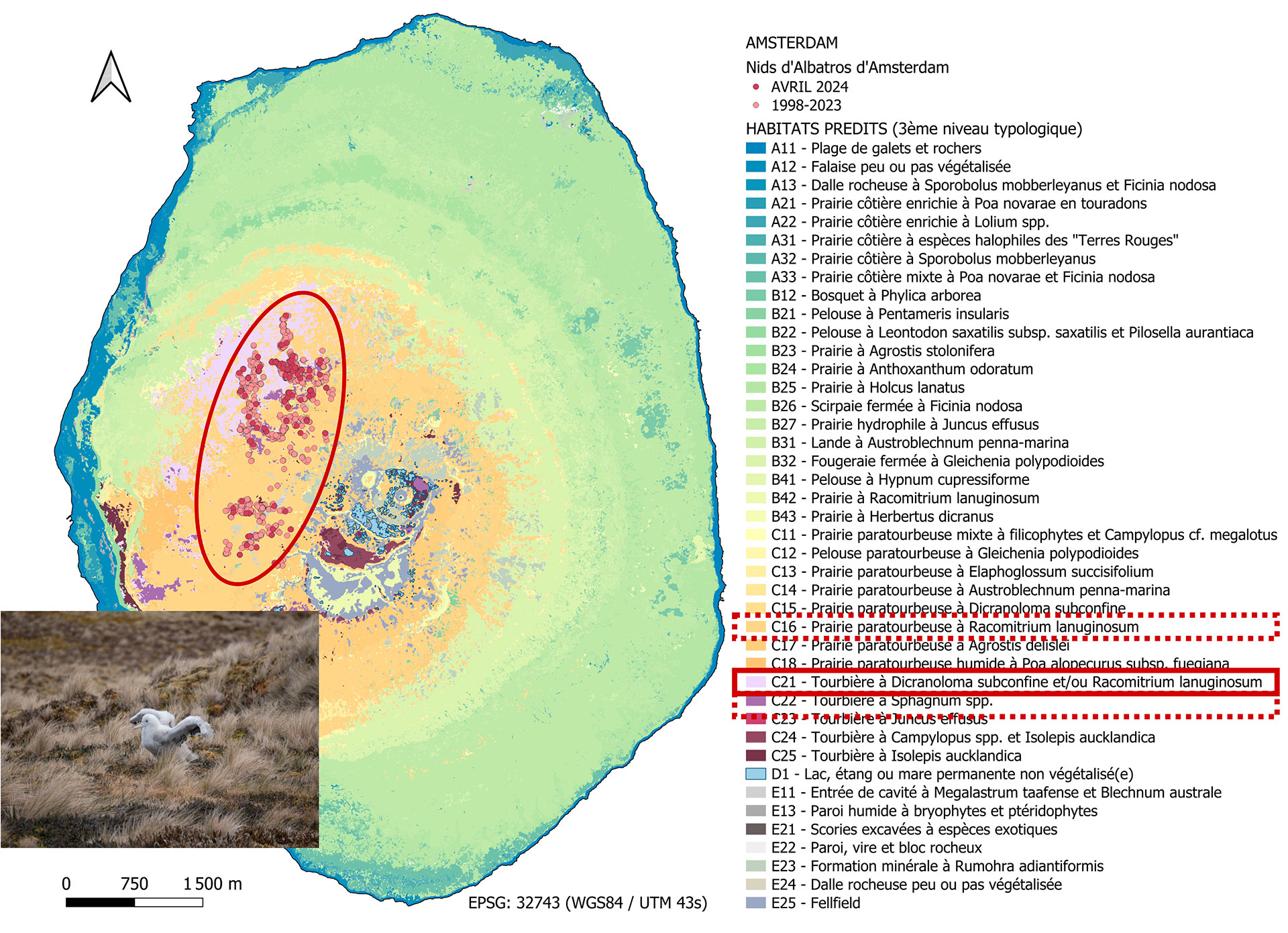 |
Habitat modelling: the added value of Cartovege2
🛰️ To model habitats across the whole of Amsterdam Island, Cartovege² used seven Pleiades and Pleiades Neo satellite images (with spatial resolutions of 50 and 30 cm respectively), acquired on various dates between 2015 and 2025 through the DINAMIS scheme, combined with a digital elevation model derived from WorldDEM Neo.
⚙️ The classification model was trained using reference data collected in 2021 and then applied to the various years for which data were available in order to enable a temporal monitoring of habitat changes over the decade. “Of the seven variables extracted from the satellite images, four stand out as particularly essential for distinguishing and modelling habitats,” emphasizes Diane: “elevation and slope, which reflect the island’s main climatic, hydrological and edaphic gradients, as well as two spectral indices (NDVI and GCCI), whose sensitivity to vegetation cover characteristics makes them particularly effective variables for distinguishing between habitats”. | The Cartovege processing pipeline has been enhanced with seven modules to improve modelling performance, increase the robustness of the processing and facilitate the operational use of the tool (see the project page for details). It is worth noting that the pipeline now runs on a standard laptop with 32 GB of RAM! |
👍 The processing workflow is available as open source here, accompanied by a comprehensive configuration guide, which Diane playfully compares to “a recipe: you just have to follow it”!
The result: a world first – habitat maps of Amsterdam Island
The habitat maps produced using Pleiades and Pleiades Neo satellite imagery enable us to reconstruct the recent history of Amsterdam’s landscapes. Thanks to optimizations to the pipeline, the typology developed and the quality of the field surveys, the results have exceeded expectations; even the exacting Diane admits she was the first to be surprised! “Using a level 4 classification scheme – the most detailed, comprising 55 remotely sensible classes to be predicted (out of the 57 existing on the island) – the model achieves excellent overall performance with a Kappa coefficient of 92.6 per cent,” she says delightedly.
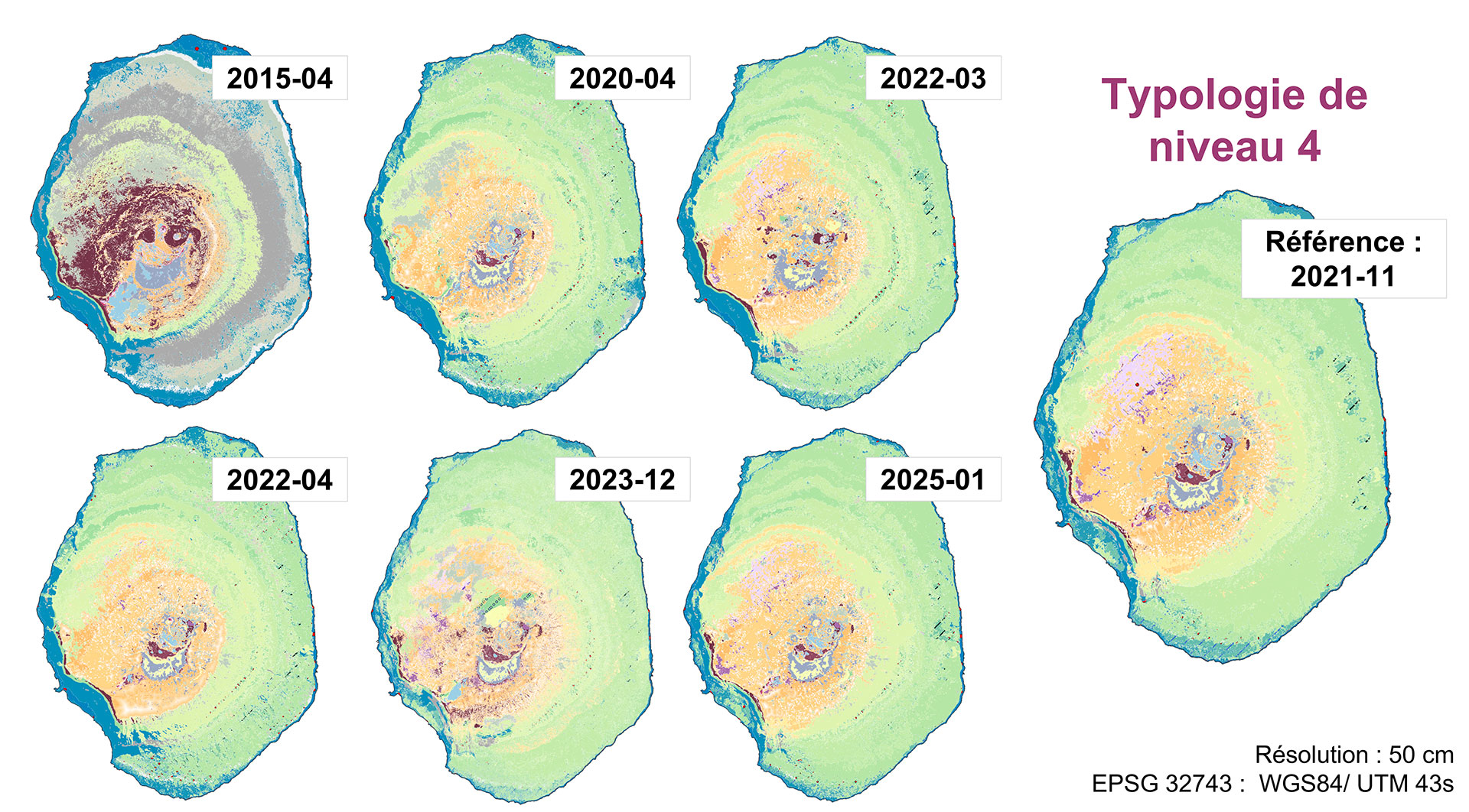
▲ Predicted habitat maps of Amsterdam Island. The 2015 satellite image, which differed too greatly from the other images, did not allow for the production of a usable map, probably due to errors in pixel interpretation. As no imagery data was available between 2015 and 2020, changes in habitats during this period cannot be documented. However, from 2020 onwards, the maps enable the changes in habitats to be tracked in detail and reliably across the entire island. © CARTOVEGE² - D. Espel (2026)
🔥 In January 2025, a fire ravaged more than half of Amsterdam Island. Modelling based on the April 2025 Pleiades image made it possible to precisely identify the habitats affected by the flames. The maps for the coming years will help guide restoration efforts.
► Predicted map of habitats before and after the January 2025 fire, which mainly affected the relatively dry, low- and mid-altitude habitats (red boxes). The fire also began to damage some peaty soil habitats (class C1), fortunately without reaching the Amsterdam albatross nests (black ellipse) which were dangerously close by. © CARTOVEGE² - D. Espel (2026) | 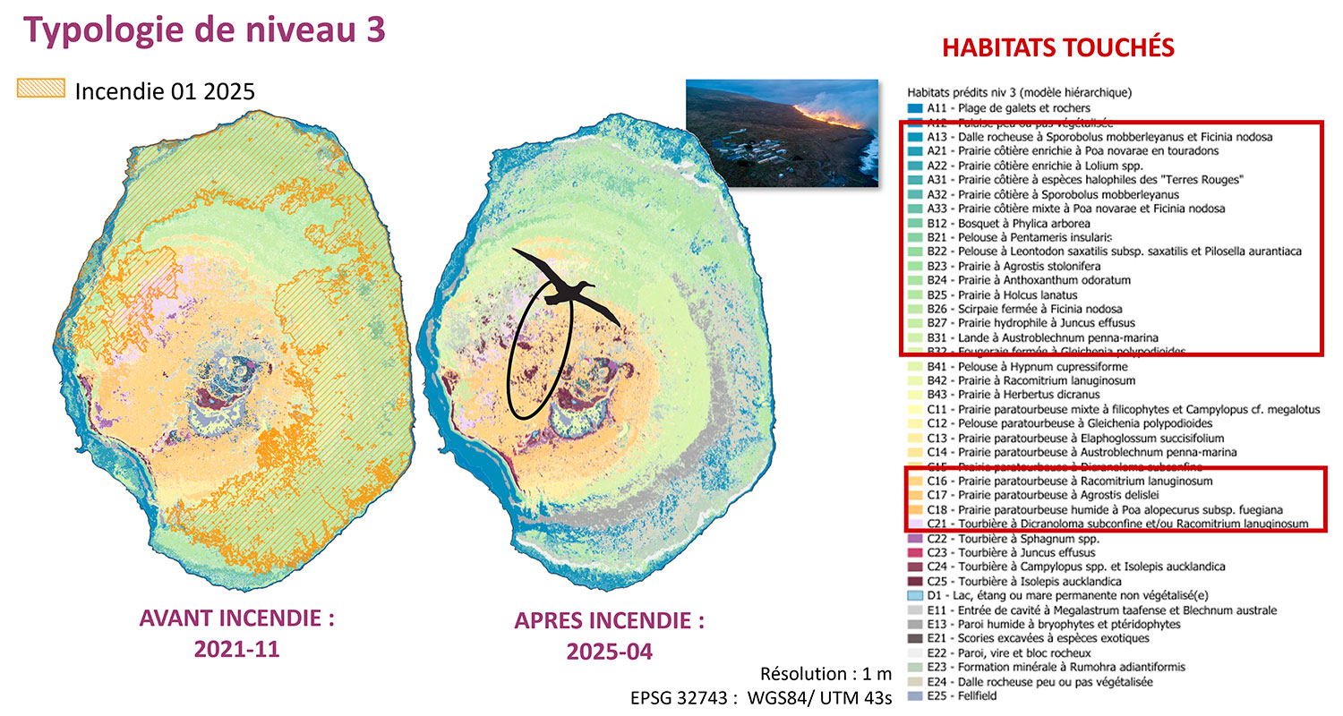 |
Application to Saint Paul Island
On Saint Paul, the challenge was even greater, partly because the team was unable to access the island, and partly because it had only a single low-resolution digital elevation model (from the USGS’s SRTM mission) and a single usable satellite image from 2024 (Pleiades Neo), due to heavy cloud cover over the southern regions. Diane and her partners therefore relied on existing scientific literature to establish a correspondence with the habitats on Amsterdam Island.
👉 The model predicts around thirty habitat classes, which only field data could confirm.
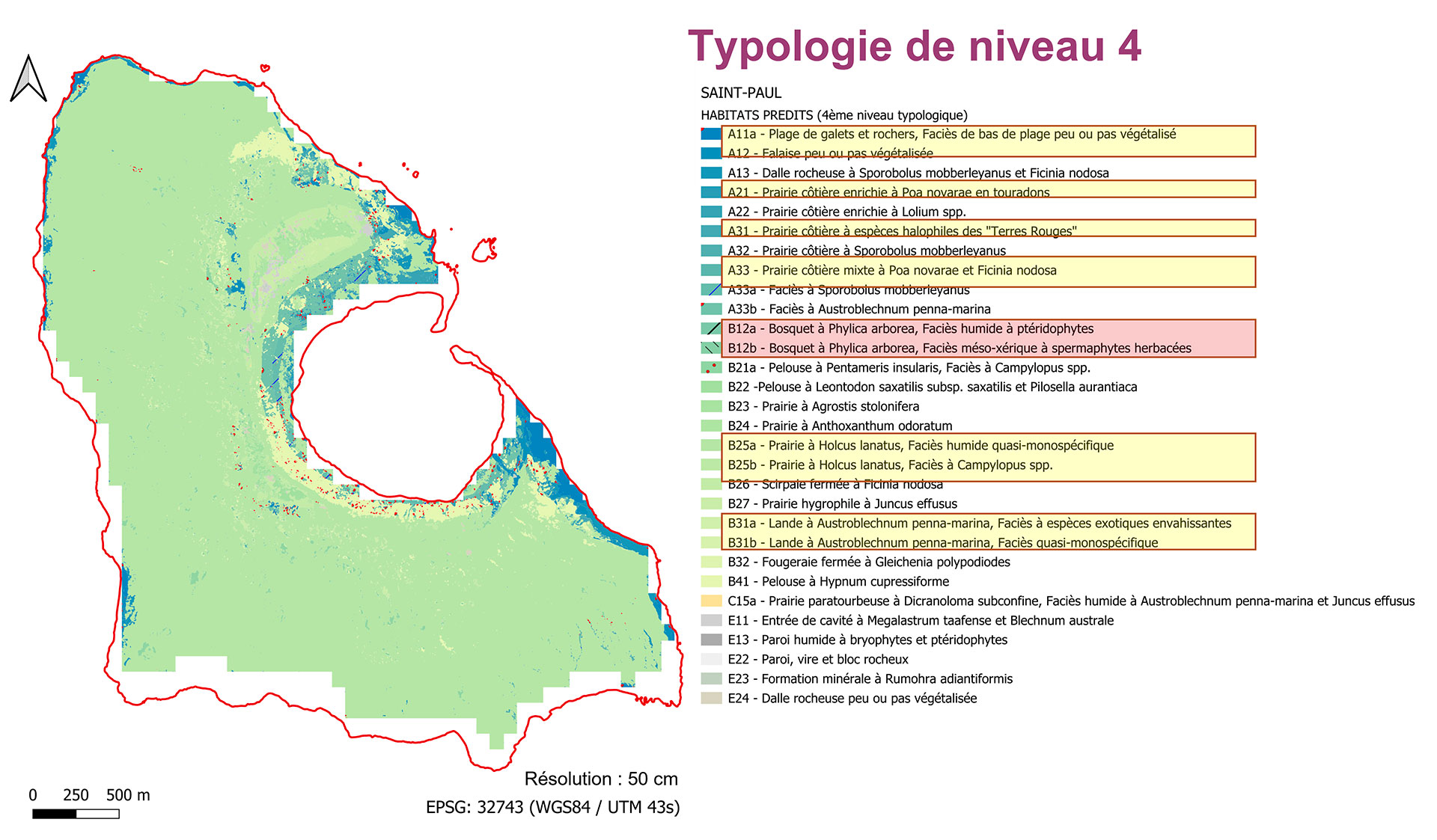 |
◀︎ Predictive map of habitats on Saint-Paul Island in 2024. In the legend, the lines highlighted in yellow correspond to the 11 known classes derived from the scientific literature. The other classes were identified by the model through comparison with the habitats on Amsterdam Island. © CARTOVEGE² - D. Espel (2026) |
A response to environmental challenges with a reduced carbon footprint
🌿 Thanks to Cartovege2, the French Southern and Antarctic Lands (TAAF) now have a precise understanding of the diversity and distribution of the island’s habitats: 80 % native habitats and 20 % dominated by non-native species.
| Each habitat has also been assessed using a conservation priority score, taking into account pressure from invasive alien species, sensitivity to climate change, the presence of iconic wildlife, and the richness of endemic and heritage plant species. This approach now makes it possible to identify and prioritize the habitats that are most strategic for the island’s conservation and management. | 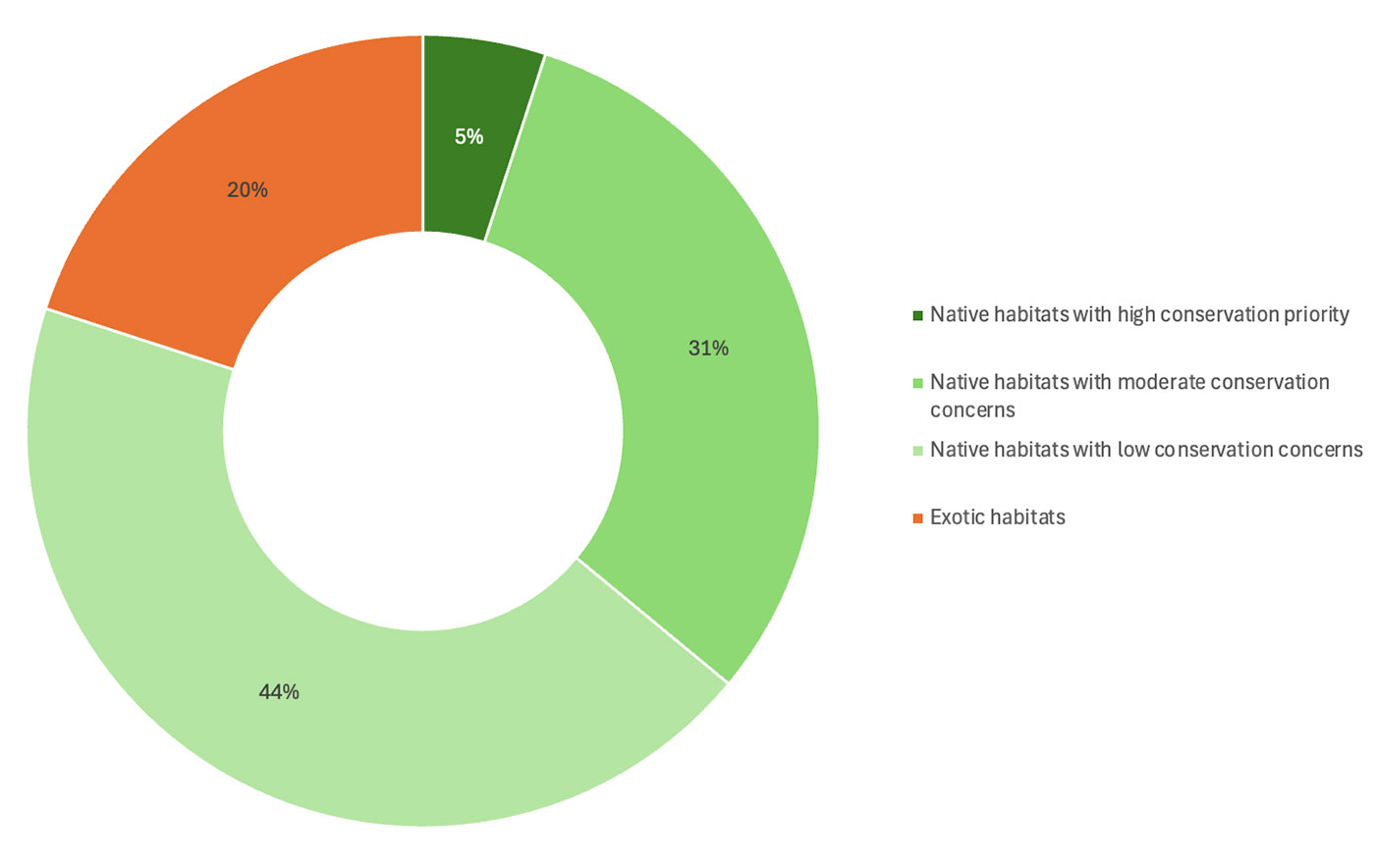 ▲ Proportion of habitats with conservation concerns. © CARTOVEGE² - D. Espel (2026) |
🦭🌱 28 % of native habitats serve as nesting and/or breeding sites for native wildlife (gannets, sea lions, elephant seals and seabirds), whilst 48 % are home to endemic or heritage plant species, highlighting the exceptional ecological value of these habitats.
👉 For the first time, it is now possible to envisage genuine long-term ecological monitoring of the island using satellite imagery, paving the way for a new generation of scientific exploration that is more responsible for these extremely remote territories. Thanks to the Cartovege tool and the Amsterdam habitat classification system, the need for high-carbon-emission field missions can be significantly reduced, with an estimated 57 % reduction in the carbon footprint for a validation mission every five years, and up to 99 % for monitoring based exclusively on satellite imagery!
Coming soon
👁️ All maps will soon be available online via the National Museum of Natural History’s VISHAB visualizer as part of the CarHab project. They are currently available on request from the Ecobio laboratory (University of Rennes / CNRS).
📚 Three publications are currently being drafted, including the “Guide to the Terrestrial Habitats of Amsterdam Island”, to be published by Quae, following the same format as the “Guide to the habitats of Possession Island” in the Crozet Archipelago. The other two publications are due to be submitted to Computers and Geosciences and Remote Sensing in Ecology and Conservation (details on the project page).
The bottom line: a perfect solution for all sub-Antarctic lands
“Cartovege is the only way to produce a comprehensive map of these islands without deploying colossal logistical resources,” says Pierre Agnola, who was the Flora Project Officer at the TAAF Environment Directorate working on Cartovege1 and who has continued to follow Cartovege2 closely. As someone who knows these islands well, he praises “the impressive accuracy of the predictions! There are a thousand potential topics for a Cartovege3…”
Project lead and now Director of the French Polar Institute, David Renault confirms: “Cartovege now enjoys considerable international visibility: it has the potential to reach new heights and expand to a new scale.” And if that is the case, rest assured, the SCO will be there to support it!
See the details of the results and methodology on the project page
| 🙏 A big well done and thank you to the staff of the French Polar Institute for all the support needed to roll out the project in the field, to the Environment Department and the field staff of the TAAF (in particular Julie Bornes, Elzéar Hamard-Mulot, Hugo Berteloot and Charlène Franc), specialists in this remarkable biodiversity, whose vital contributions Diane has consistently highlighted throughout the project. | Support from the SCO The Cartovege team would like to thank the SCO for the visibility it has provided to the project and the opportunities to exchange ideas with other project leaders, for connecting them with other institutions, and for facilitating access to satellite imagery. |