

EagleHedges

Project completedAfter a 2-year project under the SCO label, EagleHedges has achieved its initial ambitions: the creation of operational tools for monitoring and characterizing the hedgerow network using Earth observation images. An automatic hedge detection service is available on demand, and the hedge characterization tool "HedgeTools" is available as an open-source QGIS plugin. The project team is now working on bringing the tool to other territories and, as new needs arise, extending its functionalities.
OVERVIEW
Hedgerows play a key role in agricultural landscapes and are excellent levers for building resilience to climate change.
In addition to their function as ecological corridors within the green network, they provide an important refuge for biodiversity and deliver numerous ecosystem services. In addition, bocage structures represent a significant carbon sink, through their aerial and root biomass and their capacity to sequester carbon in soils.
Unfortunately, the surface area of hedgerows in France has diminished considerably over the last few decades. Today, national and European environmental policies encourage the protection and replanting of hedgerows. However, to date, there is no way of accurately and regularly characterizing the state of the French bocage and assessing the impact of these policies.
IGN and OFB joined forces in 2018 to create a national system for monitoring bocages, starting with the creation of a georeferenced data base for mapping landscapes. This has led to the creation of the BD Haie repository, integrated into the BD Topo IGN. However, this data is not sufficiently complete, and it is not planned to update it annually as part of the bocage monitoring system.
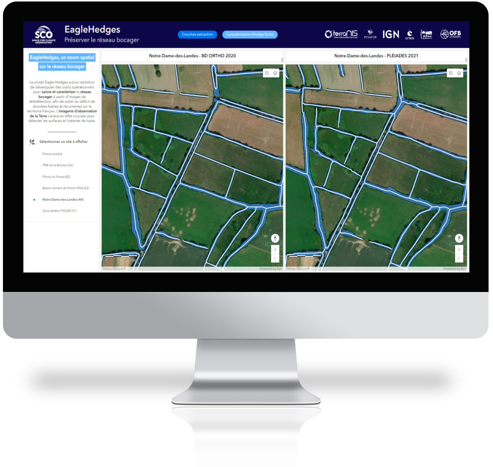
The Eagle Hedges project has set itself the objective of developing operational tools for monitoring and characterizing the hedgerow network using Earth observation images, in order to make up for the lack of reliable and recurrent data on French territory. Very high-resolution remote sensing images are crucial for detecting hedgerow surfaces and lines. They also enable recurrent updating of the state of the bocage, contributing to a more representative vision.
EagleHedges is the fruit of a collaborative effort involving players from the private sector (TerraNIS), research (DYNAFOR, UMR INRAE / Toulouse-INP), the public sector (IGN, OFB) and a network of bocage professionals (AFAC-Agroforesteries).
Application site(s)
France:
- Protection perimeter of the Kerne Huel pond (22) - Côtes d'Armor Departmental Hunting Federation (Fédération Départementale des Chasseurs des Côtes d'Armor)
- Notre-Dame-des-Landes (44) - Department of Loire-Atlantique
- Brenne Regional Nature Park (36)
- Plaine du Forez (42) - OFB
- Zone Atelier PYGAR (31) - DYNAFOR long-term ecological study site
DATA
Satellite
- Pléiades (multispectral bands + derived Digital Surface Model)
- Pléiades Neo
Other
- BD Ortho IGN + Digital Surface Model/Digital Terrain Model IGN
- LiDAR HD IGN
- BD Haie IGN
- Field survey data OFB, AFAC et DYNAFOR
FINAL PRODUCTS
- Map interface (access available on request)
- Layer of surfaces and linear hedges in experimental areas
- 2D/3D indicators to assess the multifunctionality of hedges in experimental areas
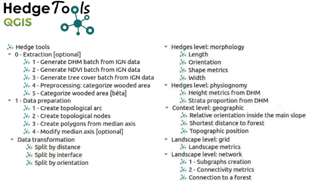
- HedgeTools software (QGIS plugin) for calculating indicators
RESULTS
The EagleHedges project addressed two major challenges:
- The implementation of an operational service to automatically extract the hedgerow areas of a territory from satellite or aerial images at very high spatial resolution, with the aim of monitoring, in the long term, their evolution and updating a national cartographic repository of hedgerows to support the implementation of national agro-ecological transition policies. This service is marketed by TerraNIS.
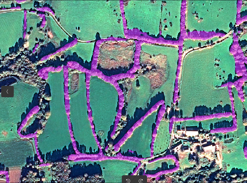 ▲ Detection of hedge surfaces from Pléiades on the perimeter of the Kernel Huel pond (Côtes d'Armor). © Image : CNES 2022, Distribution Airbus DS / Traitement : TerraNIS
- The development of an operational toolbox, HedgeTools, enabling the characterization of hedgerows from a morphological, structural and functional point of view afin to help assess the roles and ecosystem services rendered. This open-source tool is based on business indicators (PGDH) created to meet the specific needs of ongoing national programs. This tool, which is intended to be enriched as new methodological advances are made, has been developed by UMR DYNAFOR. It is currently available as a QGIS plugin (experimental version).
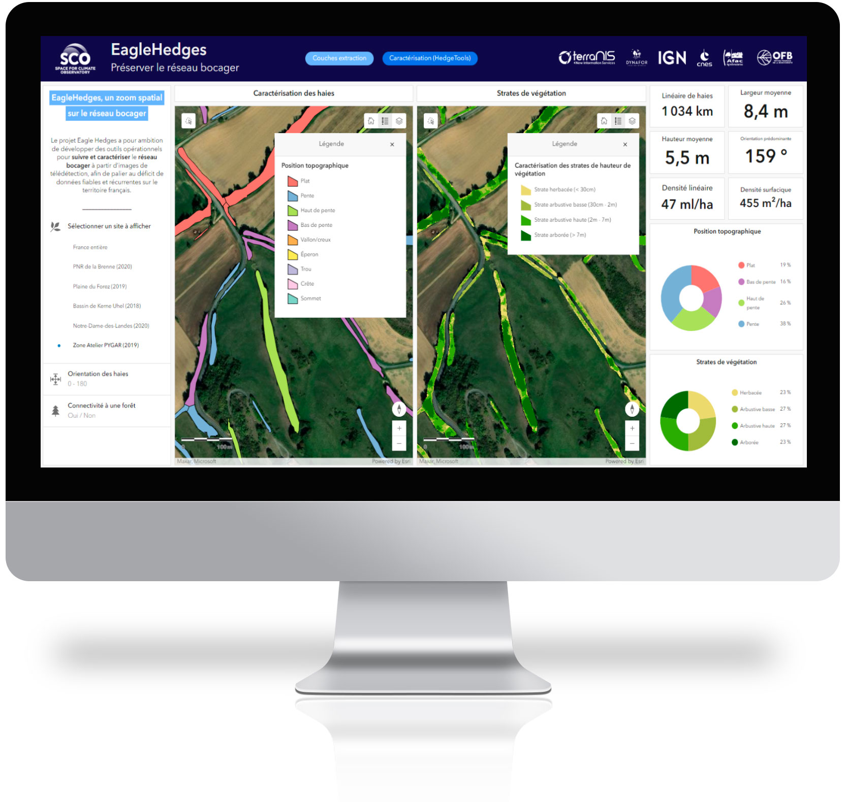
Map interface
During the EagleHedges project, pilot sites representative of the French bocage landscape were selected by the partners and their networks of local stakeholders. These sites were used to test and validate the methods and tools developed as part of the project. The maps and indicators resulting from the project have been integrated into an interface accessible on request. The interface has been designed as a dashboard to visualize the surface area, linear length and characterization of hedgerows at a given site over a given year.
|
|
|
👉 The Eagle Hedges solution is marketed by Terranis, request interface access using the contact form below or by clicking the orange button on the left.
References
| Eagle Hedges on GEO Knowledge Hub, a long lasting digital repository created by the Group on Earth Observations: https://doi.org/10.60566/dx0f3-bdy54 |
PROJECT NEWS
- 02/04/2024: EagleHedges has delivered its tools for analyzing the bocage network
- 20/11/2023: Eagle Hedges, a spatial zoom on the hedgerow network
- 13/07/2022: Presentation of the EagleHedges project and its progress at the 5th Quarterly Meeting of the SCO France on the theme "Pleiades data in SCO projects"