


SCOFrance
PartnersSCOup : GlobEO, P2E, CESBIO, CNES
Clic’Forest : TerraNIS, P2E, CNES
Useful linksProject pages:
Keywords
Forests, trees, dieback, mapping, climate variables, sustainable management


Forests in distress: SCOup and Clic’Forest take action
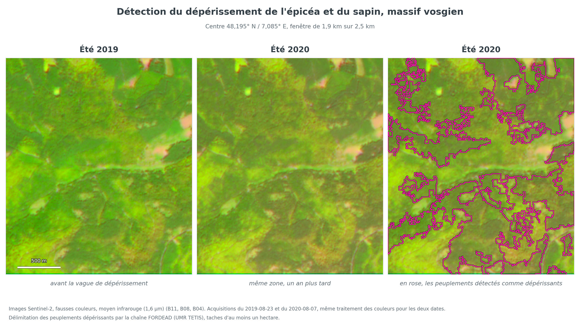
Seen from space, forest dieback from one year to the next is not immediately apparent to the human eye. But analyzed pixel by pixel, the image raises the alarm.
A deadly and growing threat
Between pests, diseases and water shortages exacerbated by recurring droughts, forest decline is ravaging the forests of what have – until now – been known as temperate zones. In mainland France, forests cover more than 17.5 million hectares, accounting for almost a third of the country’s territory. And they are absolutely vital: a refuge for rich biodiversity, a reservoir of major economic resources, but also a source of fresh air and well-being, forests are also indispensable carbon sinks. But with the acceleration of climate change, the evidence is clear: tree mortality is rising sharply.
9% of dominant trees in France are damaged or dying [IGN report – October 2026]
So today, being a forest manager and ensuring sustainable forest management is, in a sense, like being a forest doctor. This means having new tools to:
Better understand the vulnerability of forests to climatic and environmental stresses,
Rapidly detect the intensity and extent of tree decline,
- Implement targeted preventive measures.
SCOup and Clic’Forest: two complementary projects
Common features
- Accredited with SCO label in 2025, SCOup and Clic’Forest use Sentinel-1 (radar) and Sentinel-2 (optical) data to monitor forest dieback and translate this into maps, verified against field data.
- Both projects use the RECONFORT method (prediction of the health status of oak, chestnut and Scots pine trees in the Centre-Val de Loire region), which is based on Sentinel-2 imagery.
- Bringing together research laboratories and private companies, both:
- benefit from the scientific expertise of the P2E laboratory at the University of Orléans, where the RECONFORT method was developed;
- work in close collaboration with the same end-users, including the ONF (National Forestry Office) and the DSF (Department of Forest Health, a division of the Ministry of Agriculture), as well as private forestry cooperatives. In addition to their knowledge of forests, these organizations are key partners as they provide the in situ data required to calibrate models using spatial data.
Key features
SCOup - Satellite Canopy Observation for forest Understanding and Protection | Clic’Forest - Climate Change and Forest health |
What progress has been made?
🌲 The reality on the ground
Without field measurements and specialist expertise, satellite imagery alone is not enough. Both projects have therefore worked to strengthen their field databases.
👉 A joint field campaign
In 2026, the two teams jointly carried out a major survey campaign across around a hundred plot sites in various locations across France, including 22 plots surveyed specifically for SCOup. The aim was to gain first-hand knowledge of the condition of the stands and to enrich existing datasets.
► The SCOup team in the forest on 31 March 2026, where it can be seen that the trees, suffering from water stress and under attack from pests, are turning an abnormal grey color. | 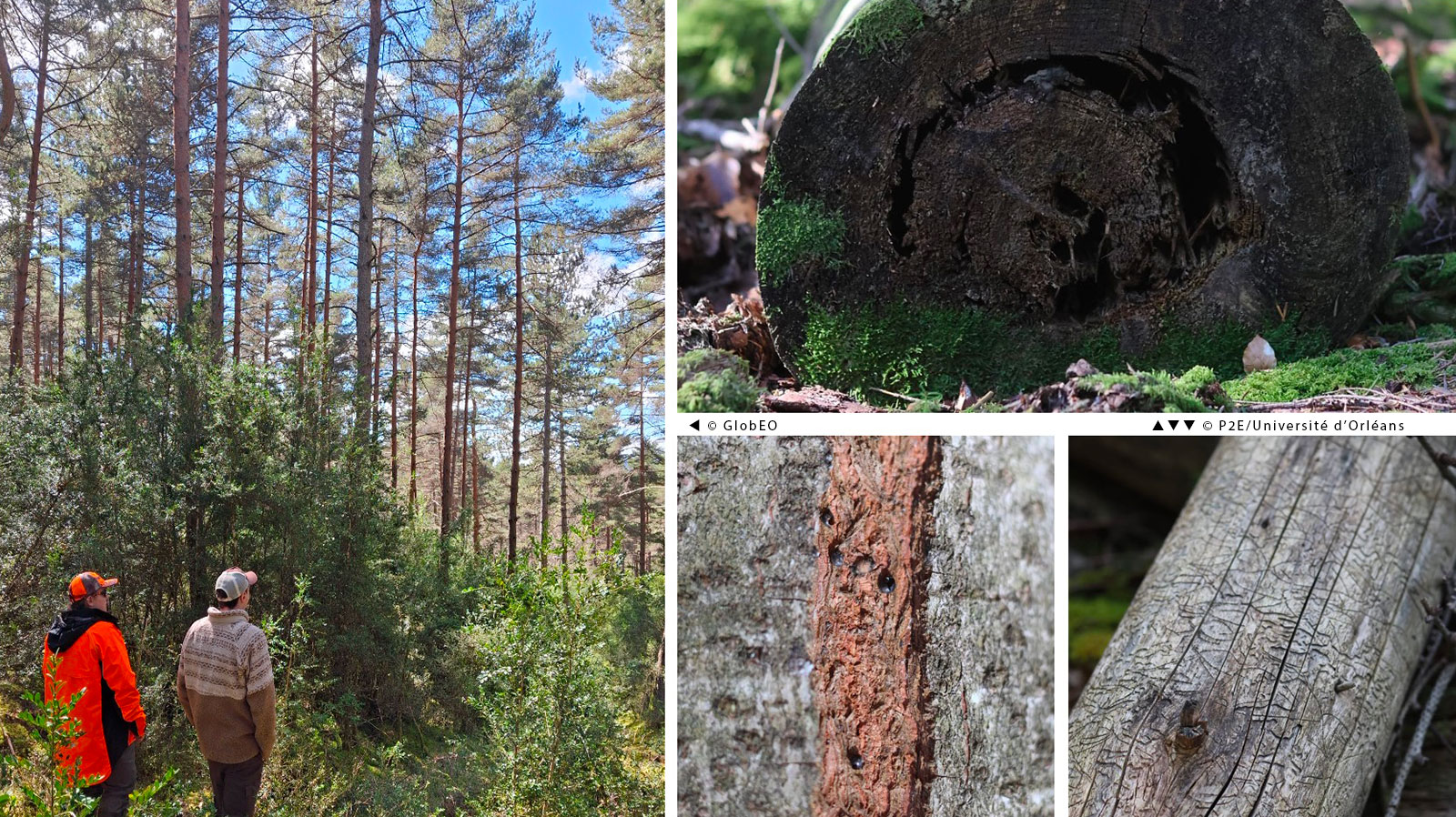 |
👉 Ten years of observations collated
At the same time, to place the current state of the forests within a long-term context, each project has collected and harmonized field observations carried out between 2017 and 2026 by forest managers and government departments, under usage agreements signed with each data provider. SCOup thus has a database of 10,600 plot sites covering the whole of the country. Clic’Forest works with nearly 9,800 plot sites located in various regions of France, supplemented by series of surveys repeated year on year, such as those from the national RENECOFOR network.
🛰️ Models for detecting tree decline and initial analyses
SCOup
► Tree dieback map of an area near Clermont-Ferrand based on Sentinel-2 imagery. © Copernicus Sentinel-2 Imagery / Processing: GlobEO | 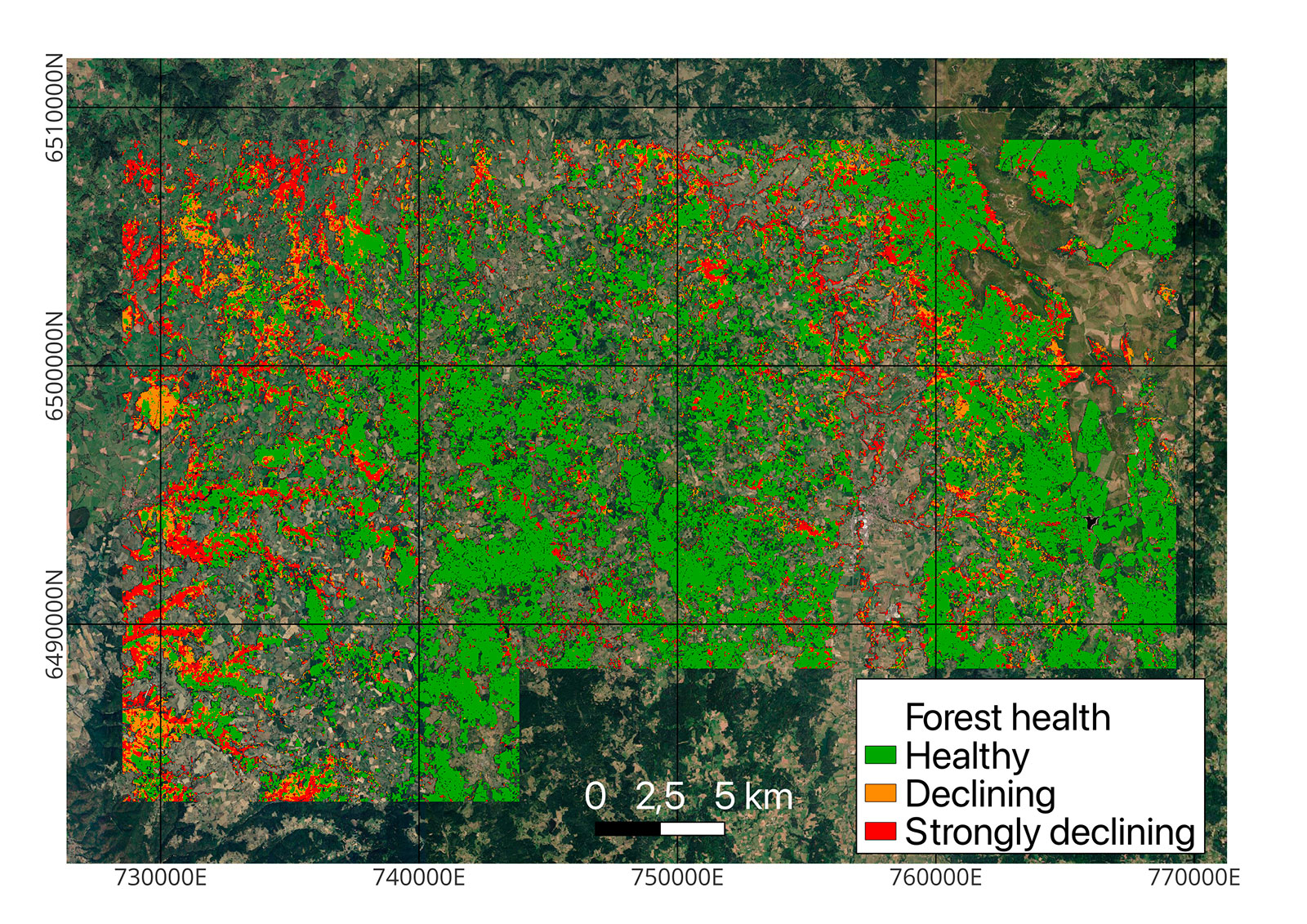 |
The RECONFORT model is currently being scaled up to the national level, covering all tree species.
Initial combinations of dieback detections with clear-cut detections, the latter model having been developed by GlobEO using Sentinel-1 data.
Coming soon for SCOup:
Develop two separate models for deciduous and coniferous trees, or even by tree species.
Apply the dieback + clear-cutting methodology at national level.
Develop an online tool featuring maps and annual statistics by municipality, department, region, and for the whole of mainland France. The tool will be hosted by IDS THEIA and the French Forest Observatory platform.
Clic’Forest
Production of the first classification maps for key tree species (oaks, chestnut trees, beech trees, pines, spruces) based on Sentinel-2 imagery, validated using field data.
Development of a data processing workflow for predicting tree dieback, inspired by the RECONFORT approach.
Creation of two catalogues listing the climate and soil parameters linked to forest dieback. The team was then able to commence a preliminary scoping study across 68 plots (figures below) to determine the strength of the link between climatic stresses and the onset of dieback in three tree species.
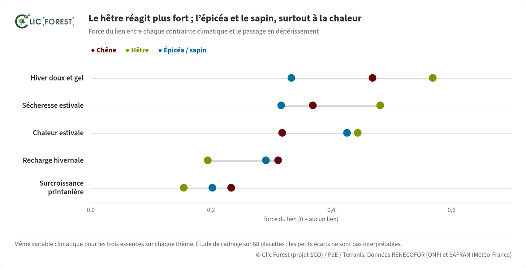 ▲ Strength of the link between five climatic variables and the onset of dieback in three tree species. It can be seen that 1) beech (hêtre) reacts more strongly than the other two species across almost all factors, and 2) winter temperature is the most significant factor for oak (chêne) and beech (hêtre), whilst spruce/fir (épicéa/sapin) is more vulnerable to summer heat. © TerraNIS | 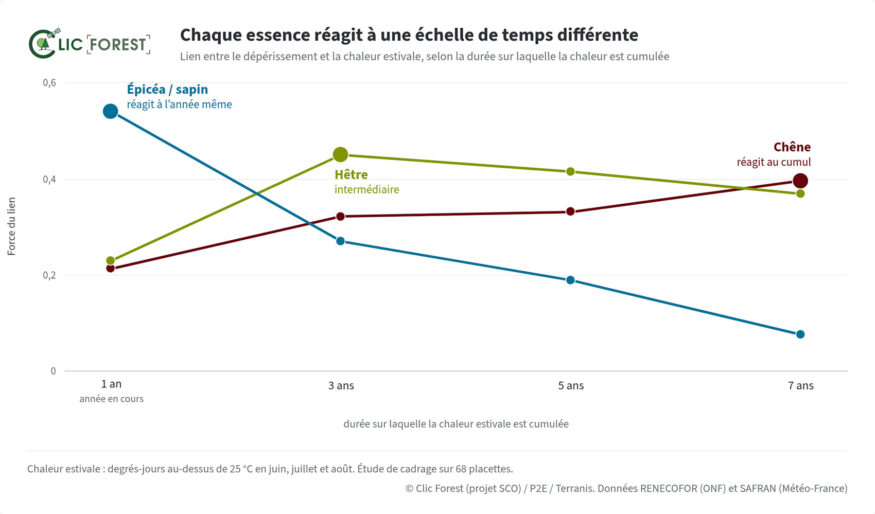 ▲ Looking here at the link between the duration of summer heat accumulation and dieback, it appears that spruce/fir (épicéa/sapin) reacts strongly from the first year onwards and then becomes less sensitive, whilst the oak’s (chêne) reaction intensifies over time. Beech (hêtre) lies somewhere in between. © TerraNIS |
Coming soon for Clic’Forest:
Cross-referencing dieback maps with climatic and soil factors to identify the main links, then developing predictive models to produce vulnerability maps.
Develop an online multi-criteria analysis tool, enabling the visualization of dieback and risks at different scales (a professional version for users and a simplified, freely accessible version).
Prepare to extend the project to other regions and tree species, both for detecting tree decline and for analyzing vulnerability.
A global challenge, tools to be shared
Forest dieback affects many countries, including the whole of Europe. Let us hope that these tools, developed in France, will help to better protect forests beyond our borders. 🌳