

HABITAT Yangtze
OVERVIEW
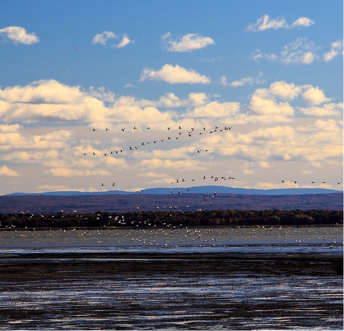
The wetland across the middle and lower Yangtze River basin is the wintering habitat for a variety of migratory waterbirds, like Oriental Storks (Ciconia boyciana, endangered) and White-fronted Goose (Anser albifrons). The migration and habitation behavior of these birds have been changing gradually but constantly, which climate change is believed to be one of the leading causes. The influence mechanism of climate change on the birds’ migration is generally indirect by altering the condition of their wetland habitats. Monitoring these features of the wetlands across the middle and lower Yangtze River basin, observing the bird distribution and migration behavior, discovering their spatial-temporal patterns, analyzing their correlation with climate change, and predicting future trend may contribute to the understanding of the impact of climate change on waterbird’s habitats and migration, and thus provide valuable information to the decision making of the middle and lower Yangtze River basin wetland management and endangered waterbirds protection facing the challenge of climate change.
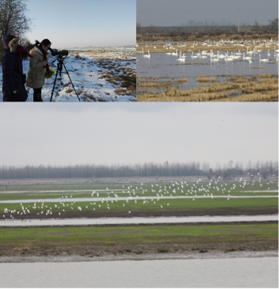
Field survey at Shengjin Lake, China. Upper left: winter observation © Li, Chunlin; Upper right: Tundra swan Cygnus columbianus © Wei, Zhen-hua; bottom: Eurasian spoonbill Platalea leucorodia © Wei, Zhen-hua
Key Laboratory of Wetland Ecological Protection and Restoration, School of Resources and Environmental Engineering, Anhui University, China has been collecting environmental attributes, observing the birds, and monitoring the well-being of wetlands through field surveys and manually remote sensing interpretation during the last 20 years. The spatial-temporal resolution of the data acquired by the previously mentioned methods is relatively low, and the field studies could not simultaneously observe all the wetlands across the middle and lower Yangtze River basin. This prevents a clear understanding of the impact of climate change on the wetland.
Addressing the limitation of the field surveys, this project monitors and maps the middle and lower Yangtze-river basin wetlands by using time sequences of multi-sourced high-resolution remote sensing imageries and the deep learning artificial intelligence-based automatic wetland objects recognition, change detection, and attribute extraction algorithms. The objective is to provide a rich-feature, large-scale, high spatial-temporal resolution, quick response, and remotely accessible database and corresponding map service of the middle and lower Yangtze-river basin wetlands to the local, national, and international birds’ researcher, protector, the wetland manager, and the climate change researcher.
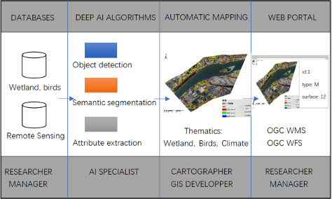
The structure of HABITAT Yangtze project © Wang, Chen
The pillars of this project are a series of deep learning models and corresponding automatic mapping algorithms. We have already developed software that integrates domestically designed and trained automatic water bodies and wetlands extraction deep model. This software can automatically identify and map water bodies, land cover types in wetlands, roads, and buildings, extract their boundaries, and detect the temporal changes from remote sensing imageries with very high accuracy (95% pixel precision and 98% area precision) in multiple test areas. The software has already demonstrated its capability to be scaled up to a large region and to a longer period.
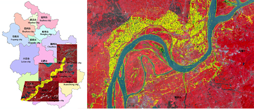
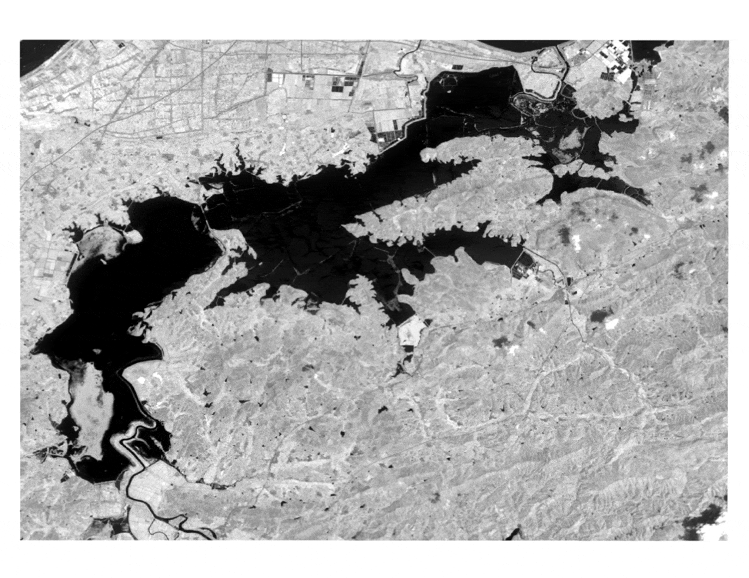
Large scale water body AI detection by HABITAT Yangtze © Wu, Yan-lan
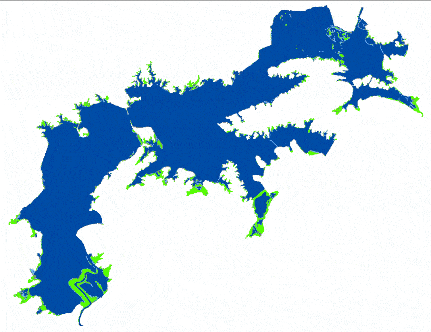
Constant deep AI land cover interpretation and automatic mapping by HABITAT Yangtze. Deep blue: deep water, light blue: shallow water, green: grass land, grey: mudflat. © Wu, Yan-lan, Wang, Chen & Li, Chun-lin
The project will provide a web portal through which the thematic map concerning the wetland attributes can be openly accessed following open standard interfaces like OGC WMS and WFS. Since the data sharing is in an open and online manner, the web portal of this project could be seamlessly integrated into global observatory networks, and thus may contribute to the understanding of the continental-scale phenomenon, like bird migration, and the global-scale phenomenon, like climate change.
Application site(s)
Anhui Province, China, with 3 main field survey regions:
- Shengjin Lake
- Caizi Lake
- Huayang Rivers & Lakes
DATA
Satellite
- Gaofen-2, satellite of China, 5 bands. Band 1 is a full-color band with a resolution of 1 meter, and bands 2-5 are multispectral bands with a resolution of 4 meters. The revisit period of the satellite is 5 days. The data will be available to international researcher soon.
- Gaofen-6, satellite of China, 5 bands. Band 1 is a panchromatic band with a resolution of 2 meters, and bands 2-5 are multispectral bands with a resolution of 8 meters. The data will be available to international researcher soon.
- Landsat-8 (OLI sensor) of NASA (optical remote sensing)
- Sentinel-2 of ESA (optical remote sensing)
Other
- Field survey data of the wetlands of Shengjin Lake and Caizi Lake
- Field survey data of Oriental Storks (Ciconia boyciana, endangered) and White-fronted Goose (Anser albifrons)
- Geographical, social, and economic data of the middle and lower Yangtze River basin
RESULTS – FINAL PRODUCTS
Take advantage of the latest:
- Remote sensing sensors
- Deep AI algorithms
- Open GIS tools and standards
Construct monitoring and mapping platform of waterbird wintering habitats: Ecodata (under construction, only Chinese currently)
- AI interpretation with high spatial-temporal resolution
- Automatic mapping
- Can scale up to the entire middle and lower Yangtze River basin
- Online thematic map display and service (Prototype online October 2021)
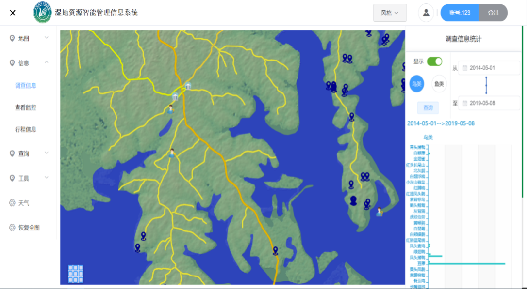
A snapshot of the web portal prototype (currently in Chinese) of HABITAT Yangtze © Wang, Chen
The high spatial-temporal and large-scale wetland-related data obtained through HABITAT Yangtze may greatly improve the potential of the models employed in the wetland-related research. It helps us spot some new patterns that could not be identified before, thus contribute to a better understanding of the impact of climate change as well as other influential factors like human activities. HABITAT Yangtze is still at a stage of testing and prototyping. The climate change-related research may get a preliminary result once the algorithm is stable, and the system is deployed.