

Littosat

Coastline monitored by satellite
Project completed
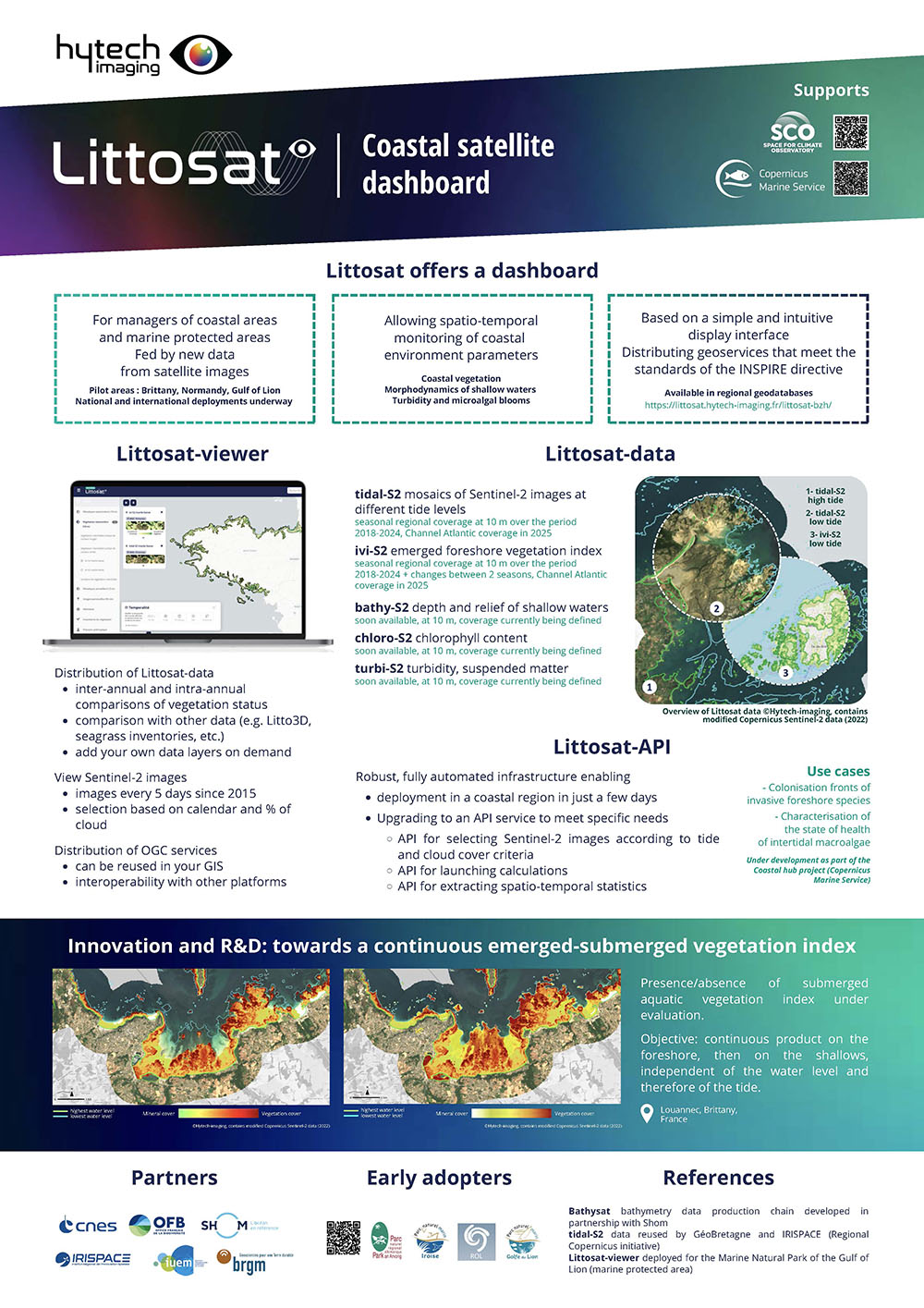
Littosat has implemented an infrastructure for the production and distribution of seasonal regional satellite products for monitoring coastal environment parameters. Based on a simple and intuitive display interface, its robust architecture paves the way for a tailor-made API service. SCO accredited in 2025, the Littosat South Africa project is bringing the tool to South Africa.
👉 Littosat product sheet
Overview
Coastal areas are attractive and fragile places, where many activities take place and where habitats need to be preserved. According to the latest report, "Chiffres clés de la mer et du littoral, 2020" (Key figures for the sea and coastline, 2020), the overall state of conservation of these habitats is assessed as unfavorable (49%) or remains unknown (46%). It is now crucial to provide tools for monitoring the health of these areas, particularly for marine protected areas, which cover a third of France's maritime area.
LITTOSAT contributes to the knowledge and monitoring of the state of foreshore habitats (part of the coastline periodically covered by the tide) and shallow waters, by providing new satellite data on coastal habitats:
-
tidal-S2: mosaics of high and low tide images, systematically at regional scales, with a seasonal update frequency and a spatial resolution of 10m.
-
ivi-S2: vegetation monitoring products for the cloud-free intertidal zone at high and low tide, with a seasonal update frequency and a spatial resolution of 10m.
-
diff-ivi-S2: products of changes in vegetation condition between 2 seasons of the same year (intra-annual), or between two years (inter-annual).
|
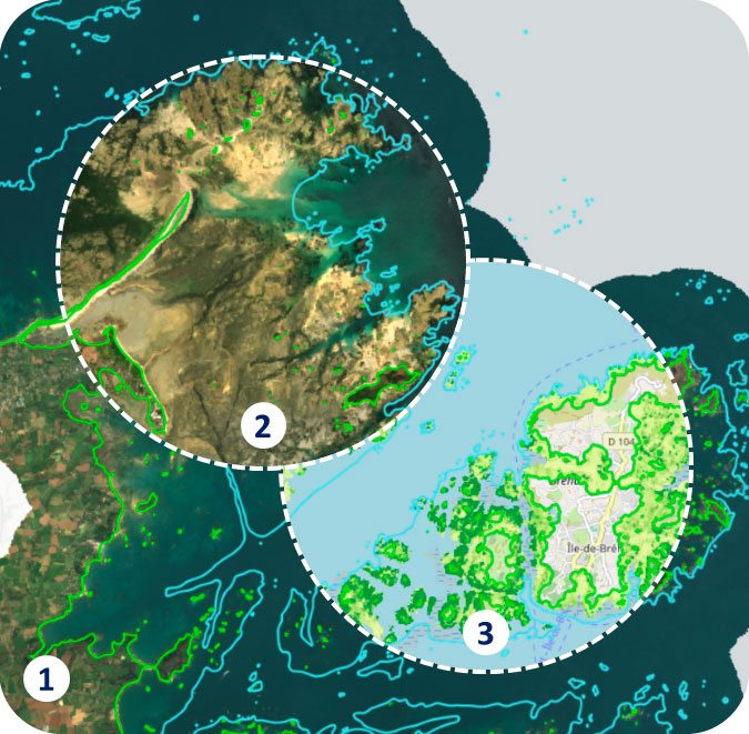
► Overview of Littosat data: 1- tidal-S2 high tide, 2- tidal-S2 low tide, 3- ivi-S2 low tide © Hytech-imaging, contains modified Copernicus Sentinel-2 (2022) data |
|
LITTOSAT thus contributes to the following two issues: how can we assess the impact of climate change and human activities on intertidal coastal habitats, and how can we evaluate public policies aimed at protecting biodiversity in these areas, particularly in the context of European directives (DCSMM, DCE)?
🤝 A better match between service and user needs thanks to growing user engagement
Throughout the project, the intermediate and final results (specification of tidal-S2 and ivi-S2 data, viewer functions, future APIs to be implemented) were evaluated by a group of end users who were very involved in the project. Their critical feedback helped to ensure that user needs were in line with the service specifications. We also compared our products and services with the commercial offerings available, developing a new and complementary offering.
Application site(s)
France :
- Brittany (Littosat data + Littosat viewer)
- Normandy (Littosat data + Littosat viewer)
NB: The study areas for the monitoring products are the Parc naturel Marin d'Iroise (PNMI) and the Rade de Brest, a Natura 2000 site managed by the Parc Naturel Régional d'Armorique (PNRA). - Gulf of Lion (Littosat viewer)
Data
Satellite
- Sentinel-2
- Pléiades
- SPOT
Other
- Mapping of existing habitats (seagrass beds)
- Natura 2000 regulatory areas (SPA, ZSC...)
- Regional nature parks and marine nature parks
- Litto3D
RESULTS - FINAL PRODUCTS
|
Two demonstrators are freely available: 👉And the Littosat Gulf of Lion operational interface |
|
Littosat Data
- Unprecedented information on intertidal habitats based on regularly updated satellite data
- homogeneously over the regional coastal area (seasonal regional tidal-S2 mosaics in natural colors, infrared colors, and ivi-S2 vegetation indicator for the emergent part of the foreshore),
- and on a study zone, a product for detecting submerged foreshore vegetation.
👉All this satellite data is distributed according to OGC (Open Geospatial Consortium) standards and referenced in SDI (Space Data Infrastructure) catalogues. In this way, the regional satellite products and tools developed by Littosat are interoperable with existing land management tools and comply with the European INSPIRE Directive.
- Production of regional-scale change detection maps for foreshore vegetation based on these data. These change maps enable managers to cross-reference satellite data with climate data and socio-economic data (management zones such as regulatory anchorage zones, intervention zones to combat the proliferation of invasive species, protection zones for habitats of interest such as seagrass beds). According to the observatory of needs set up as part of the Regional Copernicus initiative (IRISPACE), the ability to cross-reference satellite data with business data is essential if users are to take ownership of satellite data.
-
The project has enabled the development of an exploratory product for detecting submerged foreshore vegetation. Eventually, the ivi-S2 product will be extended to cover the entire foreshore, including the emergent and submerged parts, whatever the tidal level or coefficient.
Littosat viewer
- A web viewer for disseminating results to other potential end-users.
- Based on an entirely open-source tool, it can be duplicated and is already being used in other regions such as the Gulf of Lion.
💡 In order to facilitate the appropriation and adoption of products and tools by users, the LITTOSAT project offers resources (documentation on the viewer's home page) and support (webinar, demonstration on request) for the agents of partner services (PNRA, OFB, DDTM, etc.).
A robust architecture
The project has enabled a robust infrastructure to be put in place for collecting and processing images, distributing data in the form of maps and soon, exporting statistics.
👉 This infrastructure will enable the ramp-up of an API service that will make it possible to draw up maps of very recent changes, or historical changes going back as far as 2015, for areas on demand, again based on Sentinel-2 images. These data will provide unprecedented information for monitoring the impact of climate change and human activities on habitats of particular interest, such as seagrass beds, algal belts on rocky plains, or the colonization fronts of invasive species.
Continuation and outlook
The work initiated with the Parc naturel Régional d'Armorique and the IUEM, respectively on monitoring the spartina colonization front and the state of health of intertidal macroalgae as part of the DCSMM is continuing as part of the Coastal Hub Littosat project funded by the CMEMS.
Overall, Littosat is fully ready to be scaled up, particularly in areas where knowledge of intertidal habitats is lacking, patchy or heterogeneous.
References
| Littosat on the GEO Knowledge Hub of the Group on Earth Observations (GEO), a permanent digital repository: https://doi.org/10.60566/ffkac-h3v59 |
Related projects
- Regional Copernicus (IRISPACE, FPA Caroline Herschel)
- Mareos (MARitime Earth Observation Services, Evaluation of the value of Copernicus data for monitoring indicators as part of the implementation of the Marine Strategy Framework Directive (MSFD); Pôle Mer Bretagne Atlantique / BRGM).
- Littosat Gulf of Lion Natural Marine Park
- SCO Littosat South Africa
Project news
- 🎥 04/07/2025: Presentation of LITTOSAT at the 1st ClimateSCOpe “Monitoring our oceans”
- 17/09/2024: Littosat is fully operational and can be transposed to coastal monitoring
- 🎥 26/06/2024: Presentation of the Littosat project and its progress at the 13th SCO France Quarterly Meeting "Water and coastal quality"
- 23/01/2024: Littosat: 2 demonstrators online
Resources
 |
Littosat product sheet |