

MexiCorn

Adapting Mexican Corn to Drought Conditions
Project completed Thanks to its 24-month SCO accreditation, MexiCorn enabled the National Polytechnic Institute of Mexico (IPN) to validate estimation of soil moisture at different layers, as well as to train the local producers in the use of this technological solution.
Today, the algorithm that was developed is being used by the SCO VULANMEX project - of which the IPN is a partner - to implement a comprehensive decision-support tool for the Mexican agricultural sector (monitoring crop drought, irrigation, and water reservoirs).
OVERVIEW
In the last years, the Central Mexico area has been severely affected by the effects of the climate change. Drought periods have been increasing their frequency, duration and intensity resulting in a threat to domestic corn production in Mexico. For instance, in 2020, corn production in the central state in Tlaxcala dropped by 40%, due to a long drought period from April to August, corresponding to corn stages from planting to maturation.
Indeed, local governments must make decisions on the short, mid and long-term in benefit of the corn production. Currently, they have been making decisions based on local rainfall information and public national statistics databases; however, this information is limited to a few points covering the area and short period of time.
Objective
In the absence of a reliable, open-access database describing agricultural areas in Latin America countries, it is necessary to derive most of the in-situ parameters from indirect methods such as remote sensing.
This project therefore focused on creating an operational algorithm using data from optical and microwave sensors onboard of Earth observation satellites to monitor corn-growing areas. Based on this information, the aim is to try to forecast and reduce the impact of climate change effects on corn yields.
This tool developed algorithm is based on physical-based models and retrieval processes to map information that complements and/or provides a proxy of in-situ data and statistics (area planted, soil moisture, water content in vegetation). An indicator of drought conditions over agricultural areas could be obtained based on the Soil Water Deficit Index (SWDI). Among other indices, preliminary results have shown that the SWDI could be a useful indicator to determine the water content in the soil using microwave remote sensing information, particularly at L-band. The methodologies based on satellite microwave information have the advantage of being independent of cloudy conditions. The SWDI is based on the soil moisture values of the scene observed. If the values of the SWDI are lower than -2, it indicates a degree of drought.
Methodology
Ground stations were programmed to collect data every 20 min. Each station included sensors of soil moisture (SM) and soil temperature. Soil moisture was measured using CS616 TDR sensors from Campbell Scientifics horizontally located at depths of 2.5, 5, 10, 20, and 30 cm. The SM measurements were calibrated at each depth and for each site using soil samples collected monthly to cover different SM conditions. The calibrated SM measurements showed a difference < 0.03 (m3 m−3) when compared to gravimetric SM. In the case of soil temperature, the 108L Thermistors from Campbell Scientific were used at the same depths. One station containing a set of sensors was located at each monitored site.
The SM retrievals were calibrated for the agricultural area using brightness temperature (TB) observations at H (T B,H) and V (T B,V ) polarizations from the SMAP L1C_TB_E product concurrent with field observations in 2018 and 2019. The optimization to retrieve soil moisture was carried out using TB,H and TB,V independently and simultaneously both TB,H and TB,V. The convergence was reached when the difference between the estimated and observed T B,p was lower than 1 K, corresponding to the uncertainty in SMAP TB observations.
An Ensemble Kalman Filter (EnKF)-based assimilation algorithm was implemented to estimate soil moisture value at different depths and root zone soil moisture (RZSM) using a Soil-Vegetation-Atmosphere Transfer (SVAT) model over an agricultural area of Central Mexico. The main goal was to assimilate soil moisture field observations and satellite soil moisture retrievals during a complete growing season of corn to understand the effects of uncertainties in meteorological forcing on RZSM estimates when using the LSP model.
Application site(s)
Huamantla, Mexico
DATA
Satellite
- Copernicus Sentinel-1A and 1B: Time series every six days, with a resolution of 10m.
- Landsat: Time series every 16 days with a resolution of 30m.
- MODIS: Time series every 16 days with a resolution of 1 km.
- NASA SMAP: Time series of every three days, with a resolution of 36 and 9 km.
- ESA SMOS: Time series of every three days, with a resolution of 36 and 25 km.
Other
- Weather station: Weather conditions over the area.
- Archive data describing in-situ information
- SIRIS system, database provided by the Mexican Space Agency.
RESULTS - FINAL PRODUCTS
Upon request (contact form below), the project provides free access to data and products that allow to monitor production status and current conditions of water availability in order to provide information to the local decision-takers. The Mexican Space Agency is still working on providing free access to the developed products.
In longer term, the satellite-based product will provide a basis for measures to mitigate the effects of climate change (e.g. modification of the corn-growing calendars, changes of cultivars planted, etc.). As well, the processing time and synoptic nature of the products should contribute effectively to crop monitoring and to the development of long-term actions in line with preservation of native cultivars of corn adapted to new local climates.
👉 Among the different options in the SM retrieval algorithm, it was found that the single channel algorithm based on H-polarization obtained the lowest bias and RMSD of 0.016 m3/m3 and 0.049 m3/m3, respectively, for the products at 36 and 9 km.
► Calibrated soil moisture retrievals at 9-km spatial scale using in situ information and SMAP TB,V and dual-polarization observations for (a) 2018 and (b) 2019. | 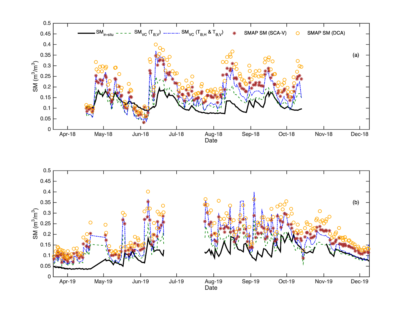 |
👉 The retrievals of RZSM demonstrated that calibrated values of soil moisture could be very useful in an assimilation framework to estimate soil moisture condition up to 10 cm. Although this improvement covers the top 10 cm of the soil, this information could be very valuable particularly on rainfed agricultural regions with lack of information about SM conditions such as Latin America, including Mexico. Frequent information (lower than every 2 weeks) of soil moisture at the top 10 cm of the soil helps local decision- makers in understanding the local effects of climate change at tropical latitudes.
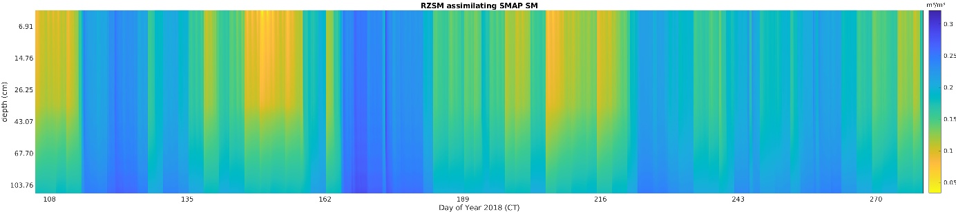
▲ Soil moisture profile up to 1-m depth when assimilating calibrated SMAP soil moisture retrievals every 3 days at 6 a.m.
References
- Monsiváis-Huertero, A., Constantino-Recillas, D. E., Hernández-Sánchez, J. C., Huerta-Bátiz, H. E., Judge, J., López-Estrada, P. A., Jiménez-Escalona, J. C., Arizmendi-Vasconcelos, E., García-Bernal, M. A., Zambrano-Gallardo, C. F., López-Caloca, A. A., Zempoaltécatl-Ramirez, E., De la Rosa-Montero, I. E., Villalobos-Martínez, R. I., Aparicio-García, R. S., Sánchez-Villanueva, C. R., Arizmendi-Vasconcelos, L., Cotero-Manzo, R., Hugo Puebla-Lomas, J., & Saúce-Rangel, V. M. (2022). “Assessment of NASA SMAP soil moisture products for agricultural regions in Central Mexico: An analysis based on the THEXMEX dataset.” IEEE Journal of Selected Topics in Applied Earth Observations and Remote Sensing, 15, 3421-3443. https://doi.org/10.1109/JSTARS.2022.3165078
- Huerta-Bátiz, H. E., Constantino-Recillas, D. E., Monsiváis-Huertero, A., Hernández-Sánchez, J. C., Judge, J., & Aparicio-García, R. S. (2022). “Understanding root-zone soil moisture in agricultural regions of Central Mexico using the ensemble Kalman filter, satellite-derived information, and the THEXMEX-18 dataset”. International Journal of Digital Earth, 15(1), 52-78. https://doi.org/10.1080/17538947.2021.2012534
Related projects
- SCO VULANMEX, a decision-support tool for the Mexican agricultural sector (monitoring crop drought, irrigation, and water reservoirs)
- BOSCO, a platform for monitoring soil moisture in Brittany (France)