

SCOLive
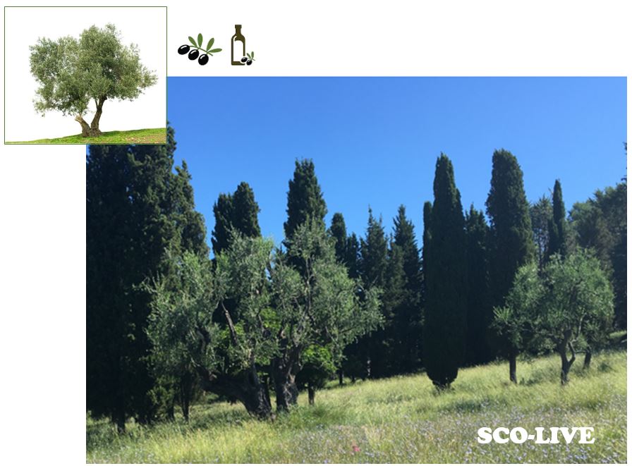
The olive tree, its vulnerability and geographical distribution as a climate indicator
Project completedWith more than 700 participatory observations, olive growers in France and abroad have shown their interest in the SCOLive observatory and the way it works: a mobile app. The ACRI-ST team is continuing to refine it while raising public awareness of the cause of the olive tree.
OVERVIEW
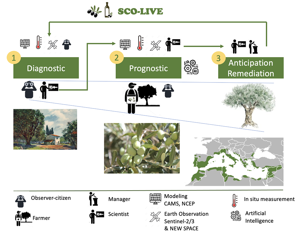
The SCOLive project (shown in the figure below) has set up an observatory to provide a better understanding of the conditions of appearance of olive tree diseases and to anticipate treatments. Using a mobile application, it brings together all the actors (occasional and professional farmers, individually or in association, and interlocutors of the territorial engineering) to map all the diseases and parasites that can harm the olive tree and thus provide relevant information to help the local public authorities in their decision making.
To do so, SCOLive relies on the feedback of geo-located and time-stamped "citizen" information from field actors. This allows i) to map the hazard, ii) to provide information to affected people on prophylactic measures to adopt, which encourages them to participate in the observatory, and iii) to conduct a scientific study (a diagnosis) on the environmental conditions conducive to the expansion of diseases affecting olive trees (e.g. Hornero et al. 2020) in order to eventually establish a predictive model (a prognosis).
This model allows two types of forecasts:
- in the short-term forecasts, to anticipate treatments and limit the consequences of these diseases,
- in the medium and long term forecasts (IPCC type), to remedy the climatic consequences in terms of health and geographical distribution of the olive tree
© ACRI-ST
To achieve this, the SCOLive observatory project has brought together a consortium led by ACRI-ST, with the Communauté d'Agglomération du Pays de Grasse (CAPG, community of agglomeration of the country of Grasse), which includes 23 municipalities and scientific laboratories, French, Italian and Spanish, experts in the biology of the olive tree and ecological niche models. The Syndicat Interprofessionnel de l'Olive de Nice (interprofessional syndicate of the olive of Nice) also supports the project.
Fully in line with the "ecological transition contract of the Grasse region, biodiversity and climate change", the observatory developed has a strong potential for geographical extension (to neighboring departments and other countries in the Mediterranean basin) due to the tools used: models and large-scale Earth observation, classic cell phone technologies.
Methodology
ACRI-ST has developed a tool for citizen feedback and environmental analysis. It enables observations to be contextualised within their environment (wind, rainfall, vegetation density, etc.) thanks to a direct link with Copernicus data and Sentinel-2 and Sentinel-3 data. These citizen reports are ingested in a database containing also Earth observation data as well as environmental conditions in which diseases and pests are observed. This information is then mined to define ecological niches by involving Artificial Intelligence (MLP/NN type, see Ashraf et al. 2017).
Different levels of users:
- This project relies on participatory science to collect data, and the first users are the private collectors, who maintain a tradition that is well established in the Grasse region. In return, the SCOLive app enables them to track the geographical evolution of diseases and to receive notifications and advice when a risk appears.
- In addition to private individuals, olive growers and nurserymen selling ornamental olive trees, who are also highly affected by olive diseases, are very interested in information and are willing to contribute to the project.
- In addition to these direct users, the Communauté d'Agglomération du Pays de Grasse (CAPG, community of agglomeration of the country of Grasse) is a member of the consortium. As the olive tree has a social, cultural and economic role, the CAPG proposes to participate actively in the communication of the project to make it known to the general public, which will facilitate the collection of numerous data.
Application site(s)
Grasse, France
DATA
Satellite
- Pléiades
- Sentinel-2
- Sentinel-3 (LST - NDVI)
Others
- Copernicus services (CAMS, CLMS, ..) and DIAS (WEkEO)
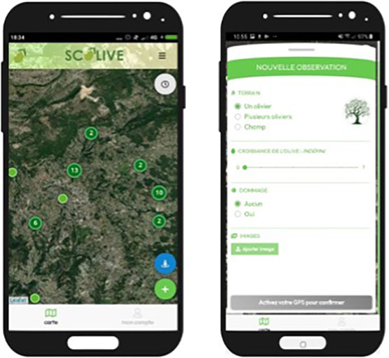
- Citizen participation data (SIMPLEX tool)
- Geomorphology and soil classification data (IGN, BRGM...)
FINAL PRODUCTS
The application is available on the stores and the observatory is open to as many people as possible (subject to compliance with a charter of use) and participation (information feedback and consultation of results) is not limited.
ACRI-ST maintains the observation database, which can be made available to users. The maps reporting the observations are freely available to all users of the application. The results of the studies aimed at defining the conditions of occurrence of the diseases will be made public through scientific communications.
Download the SCOLive app on the scolive.eu website
The tools used (application and external data) and the methods are transposable to all regions of the world and the results of this project will be directly applicable to regions with climatic similarities, notably around the Mediterranean (and presumably the southern coasts of South Africa and California). However, the environment/flood correlation studies may require local adjustments, but in principle, the system is perfectly transposable.
RESULTS
|
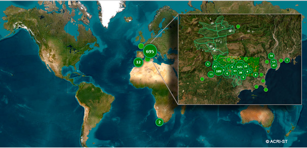
► Over the 2022-2023 period, we have recorded more than 700 participatory observations, mainly in the Grasse region, but also in Morocco, Tunisia and as far afield as South Africa, reflecting the interest shown by olive-producing countries. |
|
We focused our work on an area encompassing the 23 communes of the CAPG that are suitable for olive growing. The first objective was to establish a register of olive trees in this area, using 'twin' observations made in the field by observers equipped with smartphones (SCOLive application) and satellite imagery. The work involved analysing the satellite images and developing artificial intelligence techniques to match what was observed in the field, and therefore used as a reference, with what is known as the 'spectral signature' of the imagery provided by the satellites.
The spectral signature covers all the wavelengths, or colours (visible or invisible to the human eye), specific to a plant species. The difficulty was to be able to remove the information that did not correspond, and this was only possible thanks to the observations made by users of the SCOLive application.
|
After sorting, checking and analysing the data in the field, we were able to draw up a correspondence map enabling us to geolocate the olive trees. It is now possible to define the areas with olive trees in the region studied. This mapping was carried out by extrapolation, i.e. based on observations of a subset of the territory, learning rules were developed to ensure that the spatial imagery was able to detect olive trees (whether uncovered or in other vegetation) with a certain degree of confidence. These rules are then applied (extrapolated) to the entire area. |
|
This saves an enormous amount of travel time and reveals forgotten plots of land. For example, the Saint-Cézaire region, which was a major producer 50 years ago (there were 100,000 trees in use at the time, compared with just 10,000 today), was analysed and numerous plots of abandoned olive groves were identified, revealing a forgotten heritage just waiting to be revived!
OUTLOOK FOR 2023-2024
Validation of the observatory
To consolidate the SCOLive observatory, the time has now come for exhaustive validation of the satellite returns. Is a pixel identified as "scattered olive trees" correctly classified, and are the classifications of "deciduous vegetation" correct?
To find out, we are launching "In search of lost olive trees", a field campaign in 2023 with all nature lovers to confirm this mapping of olive trees and find the 100,000 trees of Saint-Cézaire!
Finally, once the model has been validated for the Grasse region, our ambition is to extend our surveys to other regions in France and around the Mediterranean and adapt it to the olive tree species grown elsewhere.
Extension of the observatory
In addition, thanks to contributions from the public, we will be continuing our work to refine the model. If we get enough readings, we'll be able to associate the different states of maturity and health of the olive trees with particular spectral signatures (colourations).
Professionals and lovers of this heritage will then be able to follow the progress of maturity, live, to better anticipate certain tasks, such as labour requirements for harvesting.
Thank you all for your contributions! Keep it up, and help us spread the word about this tool. In a few years' time, when we'll be able to protect trees and harvests thanks to the alerts we'll be able to issue, you'll be able to say “I was part of the start of this project!”
References
| SCOLive on GEO Knowledge Hub, a long lasting digital repository created by the Group on Earth Observations: https://doi.org/10.60566/5wb88-n1167 |
PROJECT NEWS
-
27/09/2023: The SCOLive participatory observatory is up and running
-
29/06/2023: Presentation of the SCOLive project and its progress at the 9th Quarterly Meeting of the SCO France "The SCO serving agricultural practices".
- 9/12/2022 : the app is on the stores
- 15/03/2022 : SCOLive, a very civic-minded observatory