

TAHATAI

Improving governance of the Polynesian coastline
Project completedThe QVX-PF platform (French Polynesia) has been operational since April 2022 and is gradually being fed with data and indicators on the two experimental territories, the Island of Tahiti and Arutua. The project continues in the TAHATAI Neo version for a scaling up to the whole Pacific and internationally.
OVERVIEW
The Polynesian coastal zone - Tahatai in vernacular - is the privileged place of exchanges between the terrestrial and maritime parts, where numerous uses converge. Particularly vulnerable to climatic hazards due to its proximity to the sea, this complex interface requires a horizontal, integrated and evolutionary approach to all the issues.
Within the framework of the French Polynesian Government's global "Marine Spatial Planning" program, TAHATAI's objective is to develop, implement, automate, operate, and replicate on a Pacific scale, new digital resources useful for the governance of the coastal zone. These new digital resources result from the convergence of a bundle of information from space, local databases, field knowledge and intuitive interfaces. Intended for decision makers in French Polynesia, they allow a better understanding of the evolution of current phenomena related to climate change and the anticipation of risks in the area of use. The approach, based on cognitics (automation of knowledge processing) and interoperability, is designed to be replicable and operable at a lower cost on all Polynesian archipelagos, and then on all Pacific states.
Two challenges are particularly addressed:
- The identification of areas of vulnerability on the coast and the anticipation of risks for the population;
- The protection of marine biodiversity on which local populations depend.
TAHATAI aims to improve decision-making processes on the basis of reliable, understandable and comprehensible information for decision-makers in the time available. It aims to make the dialogue between decision-makers and scientists more fluid, and tends to concretely operate targeted indicators over the long term, and to make them evolve in number and quality.
Methodology
For all this, TAHATAI relies on the QVX technology developed by the company BLUECHAM SAS. It enables the deployment of digital decision support platforms in environmental planning and management. QVX, entirely in the Cloud and equipped with a simple and intuitive interface, is part of the new generation of geographically oriented systems.
Application site(s)
The project is developed on :
- Tahiti, witness site of a "high island" (French Polynesia)
- an "Atoll" site embodied by Arutua (Tuamotu archipelago, French Polynesia)
RELATED PROJECTS
SCO Project
TAHATAI Neo, Pacific-wide and international expansion
Other
Through the technological approach of knowledge convergence, TAHATAI is closely linked to several existing projects:
- Marine Spatial Planning in French Polynesia (MATA MOANA global project)
This project is led by the French Polynesian Marine Resources Department (DRM/PF), whose overall objective is to achieve better planning of competing uses of the maritime domain in French Polynesia to preserve both the resource and the economic activity of the blue economy.
The TAHATAI project enriches the analyzed and updated databases on coastal and maritime areas. The cross-referencing of reference information and sources made available by TAHATAI allows the identification of fragile areas or areas exposed to environmental phenomena (rising waters, algal blooms, high temperatures) and human activities (overexploitation, urbanization, conflicts of use, pollution) in order to act both in the short term (administrative management of authorizations, repression, reactions to crisis situations) and in the long term (prevention, planning of the exploitation of resources and surfaces, prediction of events)
-
eQOD- Interoperability of eReef and QVX systems, for coral reef management in New Caledonia and Australia
- SMART - Analysis and monitoring of coastal subsidence, Southeast Asia
- ANR SEAMOUNTS, connectivity of seamounts, with environmental DNA approach
Oasis of biodiversity, seamounts are among the least known habitats on the planet. Yet they are undergoing increasing human impact that could impact vulnerable species. SEAMOUNTS proposes, through the dedicated QVX interface, to characterize the three-dimensional distribution of vertebrate diversity and abundance on Caledonian seamounts by combining metabarcoding (a molecular cataloging and identification technique) of environmental DNA, seascape genomics, artificial intelligence and baited video. The objective is to understand the relative influence of human, environmental and geomorphological variables on seamount fauna in order to better protect it.
DATA
Satellite
- Sentinel-1
- Sentinel-2
- Sentinel-3
- Aqua and Terra MODIS
- SPOT World Heritage
- Pleiades
- Pleiades Néo
- WorldView
- BlackSky
- Future CO3D
- Copernicus CAMS
- Satellite weather data from ECMWF (European Centre for Medium-Range Weather Forecasts)
Other: historical government databases
- BD CARTO : Data source of the cartographic reference frame of French Polynesia including vector themes (buildings, roads, contour relief, points of interest, toponymy, vegetation) and raster (multi-scale topographic maps, photographic clichés, DTM, ortho-rectified geo-referenced mosaics)
- External data: Lidar, xyz bathymetry, sampling data
- Thematic business data: land registry, maritime concessions, regulated fishing zoning, classification zone, navigation channels, anchorage zones.
RESULTS - FINAL PRODUCTS
Developed with and for the Marine Resources Directorate (Direction des ressources marines DRM), the QVX digital platform has been operational since April 2022 and has already been deployed in the three French territories of the Pacific: French Polynesia, New Caledonia, Wallis and Futuna.
QVX® technology leverages recent innovations in cloud and interoperability applied to spatial data. Based on a Data and Information Access Service (or DIAS) and a core orchestrating the interoperability of data and analysis models, the digital platform offers data, applications and indicators to the community of users who themselves compose the solution adapted to their problem. In essence, and to guarantee optimal appropriation, the implementation of the application layers is based on the expression of the community's needs. The DRM has thus expressed the need:
- To be informed;
- To have a quick, simple, online view of the territory;
- To cross and compare data from different sources;
- To download data and indicators;
- In the long term, to have dedicated management dashboards.
The deployment of the QVX-PF platform was carried out in targeted stages in order to progressively accompany the users of the DRM to an autonomous use of all the functionalities set up and meeting their needs.
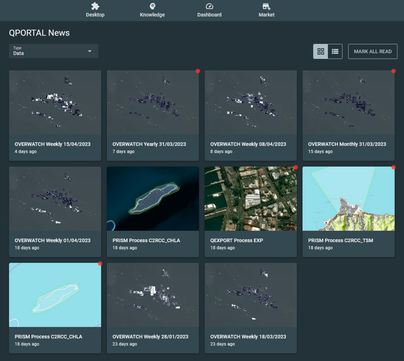
QVX QPORTAL: the gateway to the platform where the user is informed of new data and indicators. © BLUECHAM
Connected data:
QVX is connected and fed in real time by multi-source and multi-scale spatial data: from medium resolution satellite images (Sentinel-3, GOES, MODIS, etc.) to very high spatial resolution data (Pleiades, WorldView, BlackSky, etc.) and high frequency revisit data from the Sentinel-1 and 2 constellations of the Copernicus program.
The architecture of QVX is also adapted to the injection of new and innovative data from the French NewSpace. Within the framework of TAHATAI, a demonstration of capacity was carried out with the company UNSEENLABS in order to identify the boats not informed by the AIS and VMS systems of the Polynesian Government.
Capitalization and valorization of data: the DataCube
QVX integrates a DataCube device deployed to allow the capitalization and valorization of data by workgroup. The DRM thus has a structured cube of data organized in time series and spatially consistent with each other in order to allow the analysis and creation of value-added indicators. The DataCube is also the recipient of analyses that can be reused later to answer new questions.
The technological infrastructure put in place serves as a foundation for the deployment of services for marine spatial planning for climate change impacts.
Coastal and lagoon vulnerability to climate change:
In Polynesia, sea level rise varies between 5 and 11 mm/year. Eventually, 30% of the Polynesian islands are likely to be submerged: the Polynesian maritime and coastal space is at the forefront of the effects of climate change and the Polynesians will probably be the first French climate refugees. In this context, decision making and marine spatial planning require precise knowledge of the pressures and uses on the lagoons and the coastal zone.
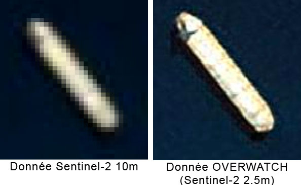
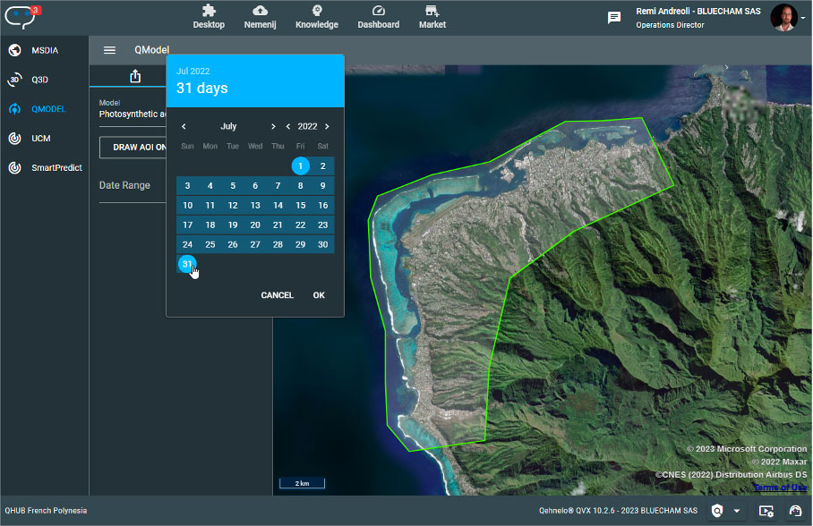
The exploitation of various connected satellite data makes it possible to establish indicators of use and pressure of human activities on the lagoon space. For this purpose, data from the Copernicus Sentinel-2 constellation are used. By passing these data sources in high definition at 2.5m through artificial intelligence processes (OVERWATCH), the automatic detection of boats and mobiles, even small ones, becomes easier and more robust. By exploiting the archive depth, QVX allows to derive usage indicators by characterizing the number and type of identified mobiles.
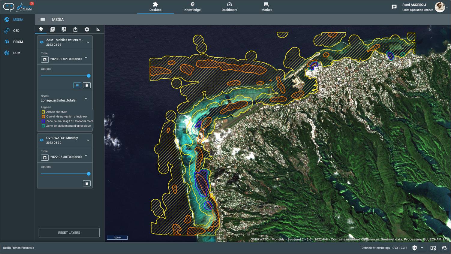
Example of zoning of uses between 01/01/2022 and 31/01/2023 in the port area of Papeete. © BLUECHAM
On the coast, indicators of pressure from urbanization, human activities in general or vegetation degradation are calculated from very high resolution data structured in the DataCube by estimating land use parameters. Automated, the indicators integrate the updated state and the dynamics of change since the last analysis.
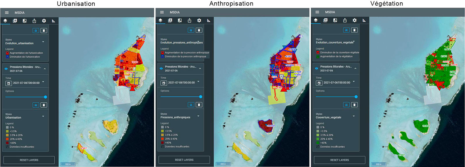
Indicators of the main pressures on the coastline. © BLUECHAM
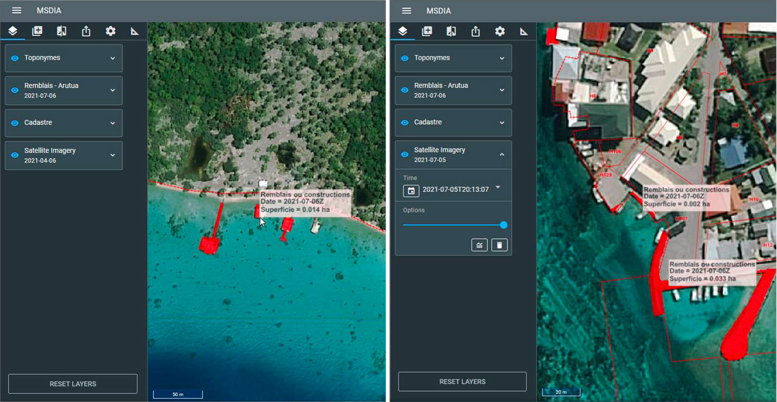
Detection of fill areas on Arutua (2021) from Pleiades data © CNES (2021), Distribution AIRBUS DS / © BLUECHAM
Identify, characterize and anticipate changes in the reef-lagoon environment in the context of climate change:
The PRISM application from QVX offers the possibility for the DRM to perform remote measurements of lagoon water quality in order to :
- Confirm the feedback from local populations;
- Monitor the state of the environment, especially those used for pearl farming or tourism;
- Optimize field verifications.
PRISM application - Interface for choosing and setting up analysis models. © BLUECHAM
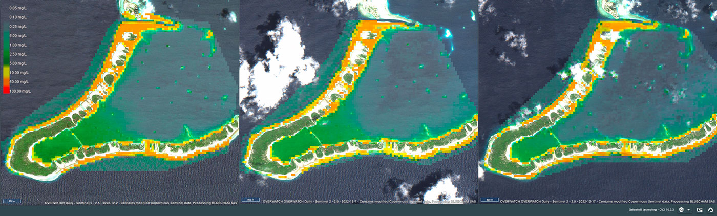
Dynamics of the phytoplankton bloom detected on Takaroa in December 2022. © BLUECHAM
👉 Regular follow-up of information on TAHATAI: https://linkedin.com/company/bluecham
Market place
 |
QVX-PF on GEO Knowledge Hub, a long lasting digital repository created by the Group on Earth Observations: https://gkhub.earthobservations.org/marketplace/items/9dctx-5jp02 |
Project News
- 22/05/2023: TAHATAI is operational and continues in Neo version
- 21/04/2022 : Deployment of the QVX-PF platform within the framework of the TAHATAI project and onboarding of the first DRM users
- 30/11/2022: Presentation of the TAHATAI project at the Pacific Geospatial Conference in Suva, Fiji, which attracted the attention of regional organizations.
- 20/12/2022: Presentation of TAHATAI project and its progress during the 7th SCO France Quarterly Meeting dedicated to SCO in the Pacific & Indian Oceans.