

SCOFrance
PartenersCLS, IRD, Mercator Ocean International, CNES
Useful linksSeSaM platform
KeywordsAlgae, sargassum, real-time monitoring, seasonal forecasts, CMEMS
Thanks to SeSaM, Europe now has a tool for monitoring and forecasting sargassum
|
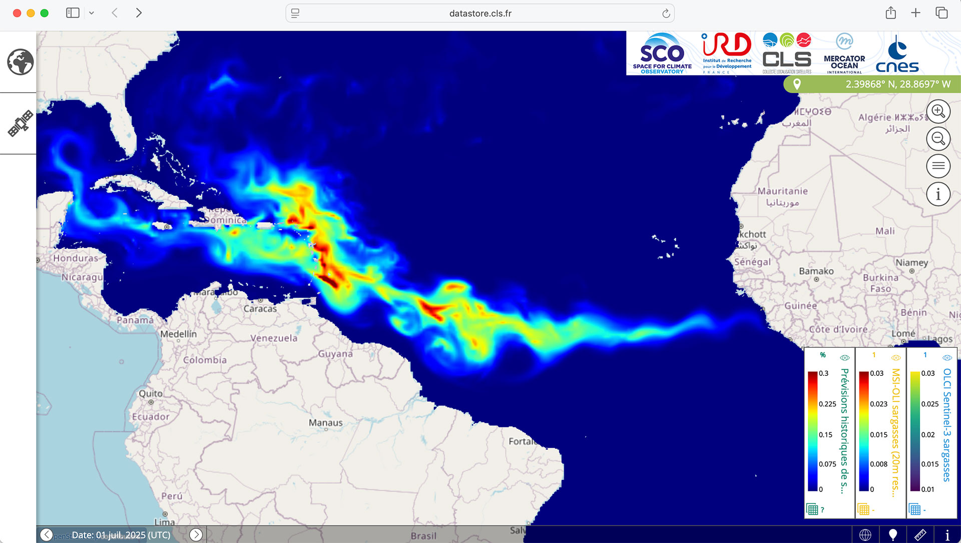
Developed and implemented by CLS, the SeSaM portal, which stands for Seasonal Sargassum Monitoring, is now fully operational. Since our last article (here) introducing this platform, which allows real-time visualization of the presence of Sargassum seaweed, a seasonal forecasting module has been added. Based on the sargassum growth and movement model developed by IRD, this module takes into account currents and water temperature, which can either limit or promote the development of algae. With kilometer-scale accuracy, it can anticipate the arrival of large volumes of algae 3 to 6 months in advance, allowing the necessary resources to be mobilized. |
💡 Did you know? |
Widespread distribution
-
The SeSaM visualization platform is freely accessible and is a valuable tool for managers of areas affected by strandings. It should be noted that it is also available from GeoBlue planet's international Sargassum Hub portal.
-
Every month since February 2024, the sargassum presence indicators produced by CLS have been posted on the AVISO website of the ODATIS cluster, where the data is available to the scientific community.
-
Since November 2025, and for at least three years, SeSaM's real-time data has been integrated into the CMEMS web , the Copernicus Marine and Environmental Monitoring Service. As a result, Mercator Ocean can directly retrieve the data for its forecasting models.
-
For forecasts covering several days and accurate to within a few kilometers, CLS markets the SAMTool service.
Marc Lucas, project manager for CLS, praises "the significant efforts of the partners who went above and beyond what was initially planned for the project": the remarkable research work carried out by IRD to model the growth and movement of Sargassum, the operationalization of oceanographic digital twins by Mercator Ocean, and CLS's generous provision of its data to Aviso.
💡For more information:
- See the detailed results on the project page
- Watch the replay of CLS's presentation, including a demonstration, at the 17th Quarterly Meeting of SCO France on 19 June 2025
An evolving tool
In 2025, the processing chain was adapted to integrate data from the Sentinel-2C and GOES19 satellites. The same will be true for the Sentinel-2D and 3C missions, which are expected to launch in 2026. In addition, a future collaboration is planned as part of the Caribbean cooperation programme to combat Sargassum, SARG'COOP.
The contribution of the SCO
Entirely based on satellite data, SeSaM obtained SCO certification in 2021. Like many projects, it had to face unexpected challenges, with the support of the SCO. Today, Marc Lucas can appreciate how far the project has come: "The SCO has been a key source of support in several respects: maintaining detection data production, strengthening cooperation between IRD/CLS/Mercator Ocean, making data and seasonal forecasts available via an open-access portal, not to mention increasing international visibility."