


SCOFrance
PartnersGET, UASZ, DGPRE, Magellium, LETG, CNES
Useful linksProject page
🎥 Presentation at the 22nd SCO France Quarterly Meeting
KeywordsSenegal, water management, water quality, reservoir volume


From water quality to the water balance, VOQUALISE refines its assessments
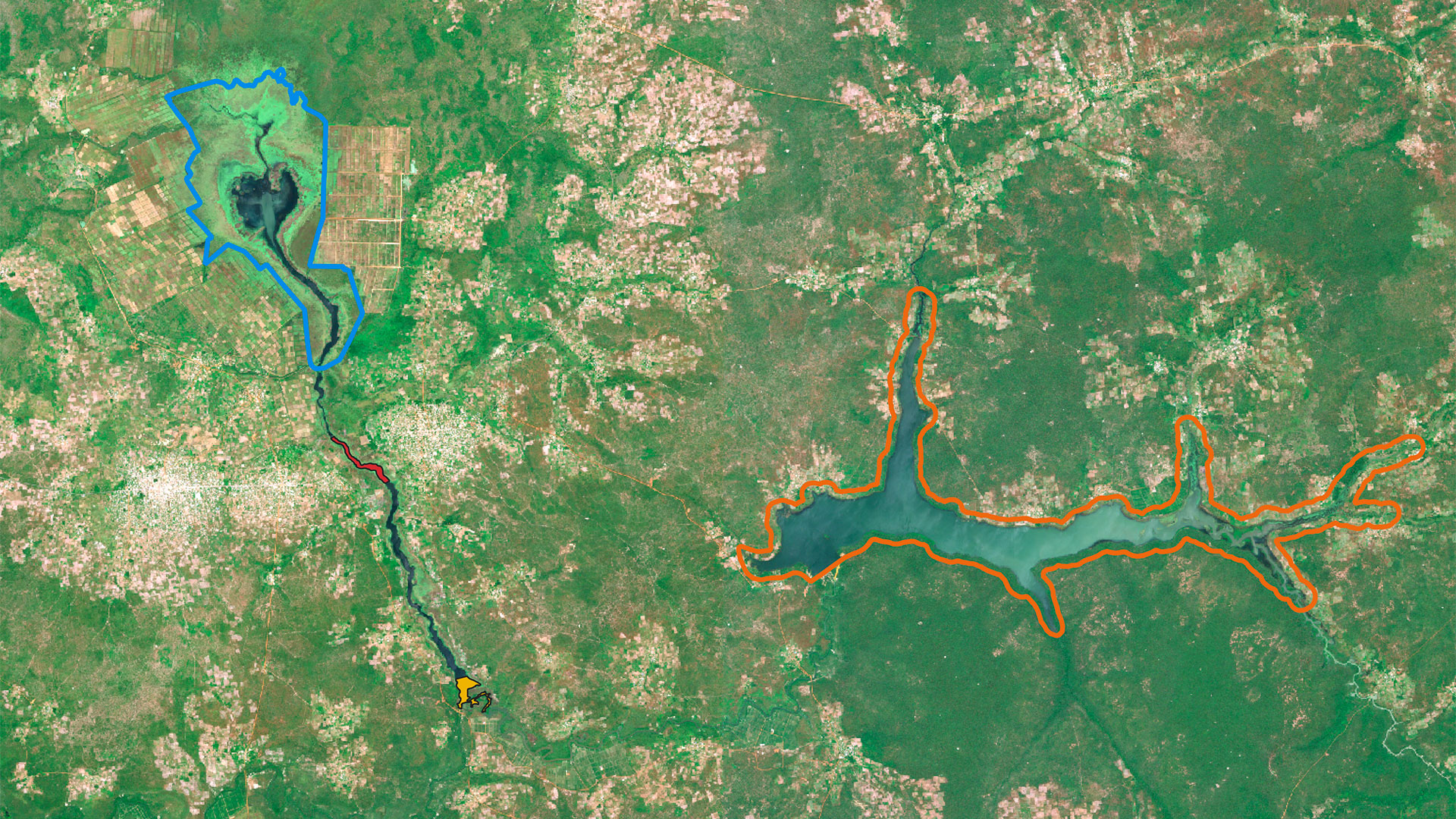
In May 2026, the VOQUALISE team told us about their mission in Upper Casamance, which was driven by the need to collect in situ data and gain a thorough understanding of the terrain to make the best use of satellite imagery. Since then, the water quality parameters workflow has been strengthened, and the team has focused on the water balance workflow.
Let’s focus on the amount of water
Given the rising temperatures and decreasing rainfall predicted by climate projections for Senegal, understanding and analyzing the hydrological balance of reservoirs is essential for their current and future management. The VOQUALISE team is therefore implementing a processing workflow that calculates a reservoir’s water balance based on satellite estimates of water levels and surface areas.
👉 SWOT satellite data (altimetry) are validated to estimate water depths, including in small water bodies such as Kounkane and Confluence.
► When applied to the Niandouba and Waima reservoirs, the water level calculations reveal different patterns, particularly in 2024. The water level in the Niandouba reservoir appears to be more influenced by annual rainfall patterns, characterized by a significant drop during the 2023 rainy season and a sharp rise during that of 2024. © Alexandre -Berrada Gomez | 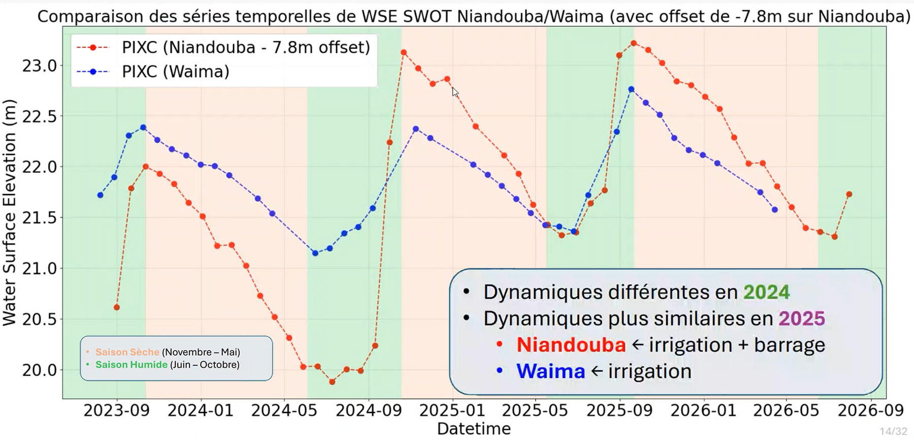 |
👉 Landsat data (optical) prove to be the most suitable for estimating water surface areas as they cover a long period (1984–2026).
👉 The relationships between water levels and water surfaces during the period where SWOT and Landsat data overlap enable changes in volume to be estimated. The analysis of the temporal dynamics of water volumes at Niandouba is consistent with the construction of the dam as well as with seasonal variations between wet and dry periods.
👉 Estimating the reservoir’s water balance – which takes into account the volume of rainfall entering the reservoir and water loss through evaporation – provides information on the other flows involved (inflow and outflow, as well as all other water losses, notably through irrigation).
► In Niandouba, A negative residual appears during the dry season (green curve), confirming the significant proportion of water losses due to withdrawals for irrigation and outflows downstream of the reservoir. During the rainy season, the peak volume (red curve) does not always reach maximum capacity, indicating that, in years of low rainfall, the reservoir’s water supply fails to replenish itself completely. © Alexandre -Berrada Gomez | 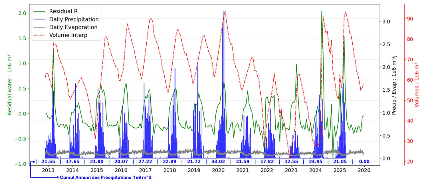 |
🎥 Listen to and watch the explanations given by Manuela Grippa, project lead for the GET laboratory, at the 22nd SCO France Quarterly Meeting on 17 September 2026, broadcast live from the GDDS. Her interpretation of the results, combined with her knowledge of the sites, is fascinating!
The highly committed Senegalese partners
In Senegal, the local partners – the DGPRE (Directorate for Water Resources Management and Planning) and the UASZ (Assane Seck University of Ziguinchor) – remain fully committed to the project, for which they have high expectations.
📏 They are continuing with on-site measurements in order to obtain a full year’s worth of data for 2026 across all pilot sites. This is no small feat, as for them it involves one or two 100-km journeys per week.
💧🕵🏾♂️ In March 2026, the UASZ and the DGPRE carried out a major survey on water use, the key findings of which they will soon be sharing with us.
Now we just need to get on with it!
“Thanks to the SCO framework, which has brought partners together and provided all the data we need, our products are now reaching maturity,” says Manuela Grippa. The team is therefore confidently embarking on its final months of work under the SCO label, namely:
implementing its Water Quality and Water Balance chains at all pilot sites for the year 2026.
- finalizing the WebGIS application that will enable the results to be presented to Senegalese users during 2027.
So, see you in a few months’ time to discover the platform and the scientific analysis of the results. It is worth noting that, spurred on by their fruitful collaboration, everyone is already looking beyond 2027.