


SCOFrance
PartnersUniversité de Rouen, Cerema, CNES, LITTO3D
+11 cmde hauteur des vagues à Dakar
Wave heights in Dakar
Useful linksProject page
🎥 Quarterly presentation, June 2026
KeywordsCoastline, coastal flooding, multi-risk index, coastal defences, Municipality of Bargny


ALISE: Senegal’s coastline under surveillance
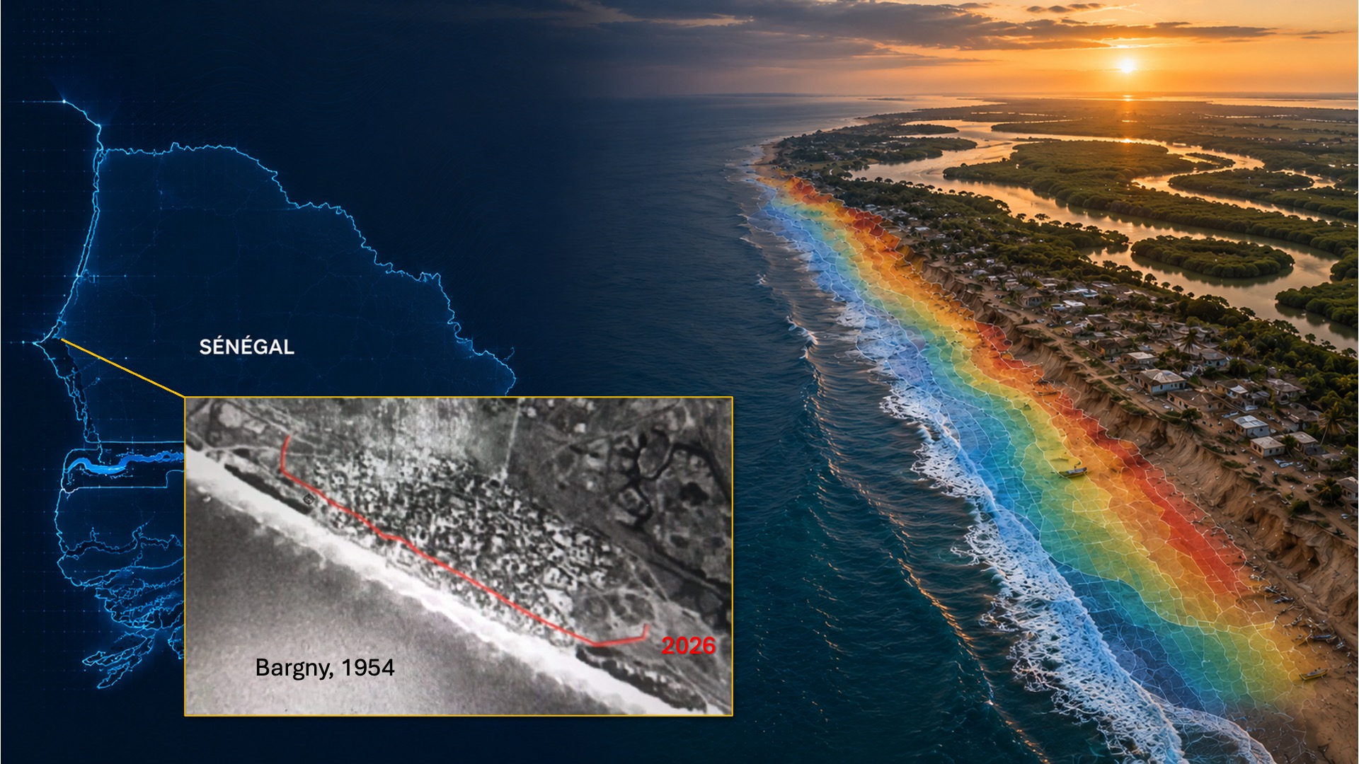
At the heart of the human challenges
In Senegal, the coastline and the sea are advancing at an alarming rate. Among the current hotspots, the commune of Bargny stands out, facing a dual challenge:
- Coastal retreat coupled with the sea advancing by more than 100 meters in 70 years, resulting in the destruction of homes and public buildings, which now lie beneath the sea.
- A decline in economic activity marked by the scarcity of fish stocks and the destruction of workplaces for fishermen and women who process seafood.
| ► In this video produced by Litto3D, the residents of Bargny show us their daily reality, explaining in particular that this situation is contributing to the illegal migration of young people to Europe – powerful testimonies that echo the news stories on European television. |
Bargny is not an isolated case: all of Senegal’s coastlines are experiencing these changes, a vulnerability exacerbated by rapid urbanization. To take action, we need to identify where the coastline is most vulnerable and promote the best management solutions for sustainable adaptation to the advancing sea.
| To this end, the SCO ALISE project is developing an innovative digital and technological solution for coastal management, the prevention of risks associated with coastal erosion, and the sustainable planning of land use along the Senegalese coast. Led by the University of Rouen (France), the project is being carried out in close collaboration with the consultancy firm Litto3D, whose on-the-ground expertise is indispensable. Building on the work of the SCO OSS St Louis and WACA-VAR projects, the tool promises to be particularly comprehensive. | Designed to benefit sectoral ministries and coastal municipalities, the SCO ALISE project is a Franco-Senegalese initiative fully aligned with the ‘Senegal 2050’ National Transformation Agenda, particularly its third pillar: ‘Sustainable land use planning and ecological resilience’. |
Identifying the most vulnerable areas
Subject to rising sea levels and the force of the waves, the coastline erodes before being swallowed up by the water, particularly where the terrain is low-lying. To identify the coastal areas most at risk, ALISE uses satellite imagery to develop a CVI (Coastal Vulnerability Index) measuring coastal erosion and a FVI (Flood Vulnerability Index) measuring the risk of flooding following an extreme event. By cross-referencing these indices with socio-economic data (population, road network, infrastructure, fishing and tourism activities, etc.), the system calculates a multi-risk vulnerability index. “We work at the ‘grid’ level of satellite imagery – that is, on a small regional scale – because we realize, as shown in the film, that we need to take into account the specific characteristics of each area to meet the needs of local decision-makers,” emphasizes Julien Deloffre, project lead at the University of Rouen.
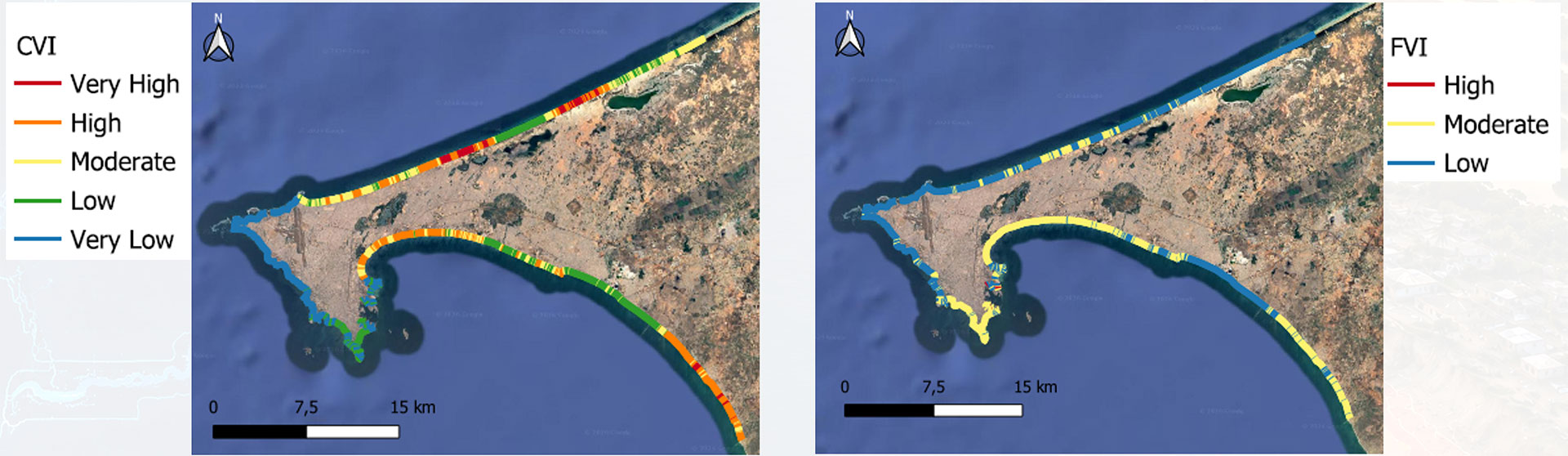
▲ CVI, the coastal erosion vulnerability index (left), and FVI, the flood vulnerability index in the event of an extreme event (storm) (right). Although these indices are still under development, these initial results show that a high CVI does not necessarily correspond to a high FVI, as illustrated by the upper section of the coastline shown above: on the left, erosion is generally severe, whilst on the right, the risk of flooding is low. This is because this section consists mainly of sand dunes, which the sea is gradually eroding, without managing to overcome their height of 30 to 40 meters. © ALISE
In the complex environment of the Casamance River estuary, the team tested and validated the use of SWOT satellite data. (Re)discover our news item from 21 October 2025, ‘ALISE validates SWOT for microtidal hydrodynamic modeling’.
Understanding what is happening at sea
As the residents of Bargny mention several times in the video, they now dread the month of August every year. To get to the bottom of the matter, the team analyzed ERA5 hydrodynamic data on wave height and direction dating back to 1940. ERA5 is a climate monitoring dataset produced by the European Centre for Medium-Range Weather Forecasts (ECMWF) as part of the Copernicus Climate Change Service (C3S).
“We can see a clear change in the swell pattern from 1973–1974 onwards, with events that could be described as storms,” summarizes the consultancy Litto3D. “This translates into one storm per year now, compared with one every five years previously, with higher wave heights: +7 cm in Saint Louis, +11 cm in Dakar and in Casamance,” it continues.
👉 Thanks to this research, the team is developing a storm detection tool.
Providing all this information to local managers via an online portal
The COASTGIS operational platform is currently under development. Designed as a decision-support dashboard, it offers a wide range of functions:
- Multi-hazard mapping; in particular, each local authority will be able to generate its own map of the coastline between two dates, complete with trend graphs.
- Layout and effectiveness of existing protective structures, such as breakwaters.
- Identification of erosion hotspots.
- Storm and flood warnings sent via text message to the public.
Projections for the coming years to visualize the expected evolution of the coastline and/or simulate the effectiveness of protection projects.
The platform will be officially launched at the end of 2026 and refined based on user feedback, including that from the municipality of Bargny. According to Professor Issa SAKHO, whose presentation of the tool at Senegal Space Week was met with great enthusiasm by coastal managers, ALISE is well-placed to support the establishment of a Coastal Observatory in Senegal. Watch this space! ► Demonstration of the future COASTGIS platform. © Litto3D |