

OSS Saint Louis

Assessing the vulnerability of coastal populations and economic activities
Project completedBy combining multi-satellite and socio-economic data, the project has produced the SCO St Louis mapping interface, whose indicators and simulations can help coastal areas to become more resilient in the face of climate change. Using a reproducible method, the results highlight the key role of compiled satellite data in accurately investigating the multi-scale variability of coastal systems in response to hydrodynamic conditions and their vulnerability in the global context of climate change.
OVERVIEW
Coastal environments are complex systems with a particularly high degree of interaction between the physical, ecological and social components. Around one-third of West Africa’s inhabitants live on the coast, and the population is growing at a rate of 4% per year. Coastal areas produce 56% of regional GDP. Fishing is a particularly important activity, with sales totalling an estimated 2.5 billion dollars on the wholesale market. Moreover, a number of major cities are located along this coastline, including Dakar and Saint-Louis in Senegal, as well as several key ports (trade and fishing).
These coastal ecosystems are under threat, not only from the development of non-sustainable infrastructure, poor management of resources and natural habitats and pollution, but also from the impacts of climate change. Ineed, phenomena such as sea level rise, storm surges and overflowing coastal rivers are leading to greater coastal flooding and erosion, thus increasing the vulnerability of the region and its population.
In some areas, the coastline is receding by up to 10 metres every year. Between 20% and 30% of mangroves have been destroyed or severely damaged over the past 25 years. This is also true in Senegal, where the coastline is receding at an estimated 0.5m to 2m every year. At the same time, the country has been impacted by flooding caused by high rainfall, overflowing rivers and/or storm surges, industrial and domestic pollution, saltwater intrusion and mangrove destruction.
To address these issues and establish the necessary balance between ecosystem protection and economic development, it is vital to precisely track hydrodynamics, morphology and sedimentology on different scales in time and space, and to combine this process with modelling, in order to better understand, plan and manage the changes taking place in these environments.
The project team therefore selected a region of study that is representative of the hazards and risks encountered in Senegal and, more widely, in West Africa as a whole. That region is the coastline of Saint-Louis, which is particularly exposed to coastal erosion and flooding (from the Senegal River and storm surges).
The Saint-Louis OSS project was built around four complementary objectives:
- Provide more information on the many hazards (flooding by storm surges or the Senegal River, the receding coastline) and associated risks experienced by coastal areas, based on an approach combining existing in-situ data (on the water level, DGPS surveys, etc.), with dedicated population surveys and multi-sensor data from satellites (including coastal altimetry) and in-situ sources (video camera, DGPS topographical surveys), statistical processing and mapping simulations;
- Identify current and future high-risk hotspots relating to climate change and linked to rising sea levels;
- Supply tools and indicators of population vulnerability, economic activities and infrastructure based on a cross-cutting approach combining the processing of satellite, in-situ and socio-economic data with mapping simulations;
- Raise the awareness of players and encourage a multi-risk vision to address the problems of coastal areas and to jointly build the coastline and coastal cities of the future.
Application site(s)
Saint-Louis coastline in Senegal
 |
The observations, measurements and simulations focused on three working sites:
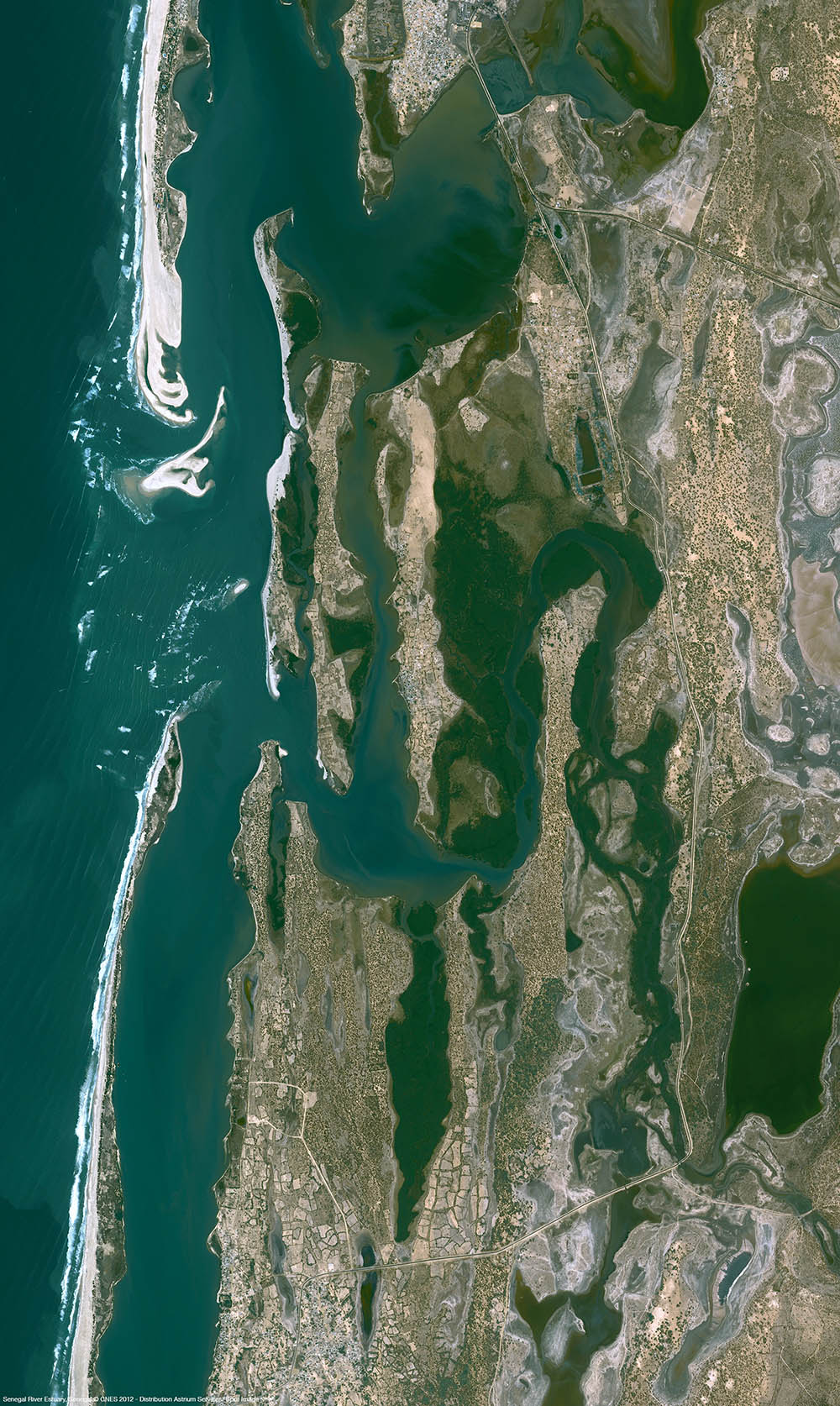
◀︎ Located at the mouth of the Senegal River (seen here by the Pleiades satellite), Saint-Louis is sensitive to coastal erosion and subject to both the Senegal River floods and storm surges. © CNES 2012, Distribution Airbus DS |
DATA
Satellite
Other
Multi-source in-situ data including:
- tide-gauge data,
- video camera data
- results of social surveys.
RESULTS - FINAL PRODUCTS
|
|
◀︎ The SCO St Louis interface can be used to visualise the risks and vulnerabilities of the coastal city and to simulate flooding scenarios. © Resallience |
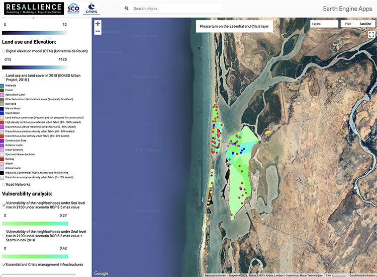
All the planned elements have been developed and combined in the SCO St Louis mapping site, created by the consultancy RESALLIENCE:
- Identify the main floods that have caused damage in the past
- Establish scenarios for flood mapping simulation
- Quantify the rise in the sea level near the coastline based on existing altimetry data
- Conduct flood mapping simulation with several scenarios of rising sea levels
|
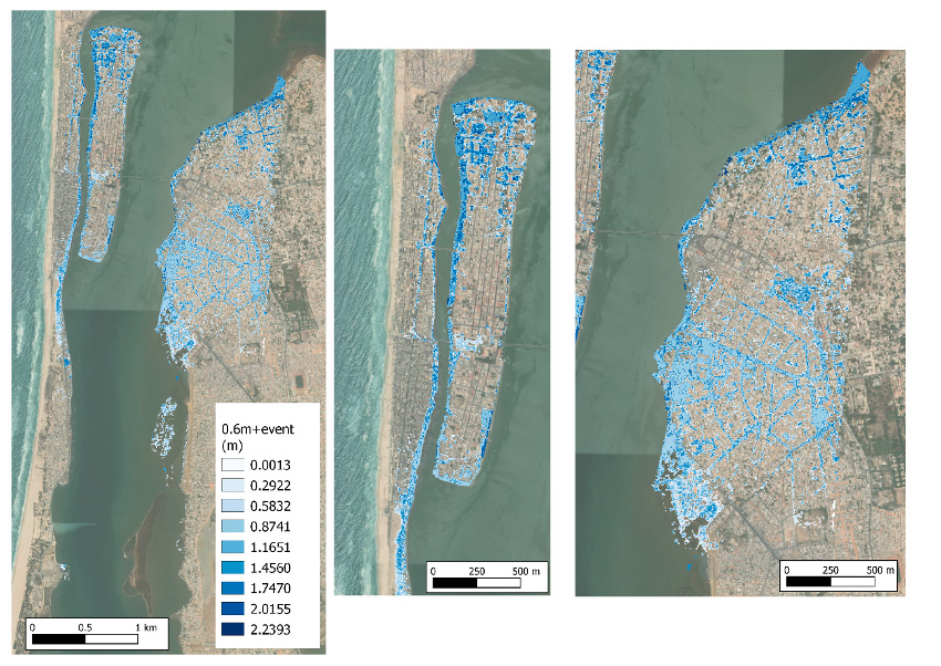
► Scenario 1: Riparian floodplain considering a sea level rise of 0.6 m (minimum rise in IPCC RCP 8.5 scenario) with an extreme water level event in the river with a water level rise of 2.3 m. |
|
|
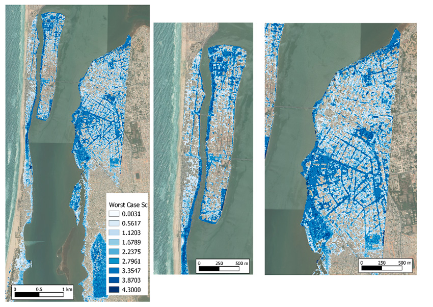
► Scenario 2, more pessimistic, encompassing three key factors: a 1.2m rise in sea level (the minimum rise in the IPCC RCP 8.5 scenario), the impact of a coastal storm and the influence of extreme river water levels. |
|
- Establish the reference DTM for shallow water bathymetry and the topography of intertidal zones
- Develop an automatic algorithm for coastline detection
- Create a geospatial database of high-risk areas and high-risk factors, including the mapping of current and future hotspots.
The final technical report, which can be downloaded below (in French), details the method and results , and includes the following extracts:
-
The Coastal Vulnerability Index shows that 70% of the study site, i.e. 7 km, has high to very high vulnerability values, particularly in the three densely populated districts.
-
The Flood Vulnerability Index shows that 2.7 km (29%) of the coast has high values, medium values correspond to 1.5 km (16%) and low values cover 4.7 km (55%).
👉 The approach used to characterize flood hazards (submersion by sea rise, storm and overflow) is based mainly on the use of satellite data and is therefore easily replicable on other territories.
- The comparison between the risk perception maps used by local stakeholders and the territorial vulnerability maps shows that the use of detailed vulnerability analyses is useful for guiding the city's adaptation strategy. For example, the stakeholders interviewed attributed a very high level of vulnerability to the Langue de Barbarie as a whole, whereas the territorial vulnerability analysis enables a distinction to be made between the different districts of the Langue de Barbarie, depending on the physical vulnerability and territorial importance of the infrastructure in these districts.
👉 The method for analyzing local stakeholders' perception of risk (interview guide and AHP method) and the framework for designing the monitoring system could be replicated to guide and feed into co-reflection and strategies for adapting to climate change in the coastal areas and coastal towns of tomorrow.
References
| OSS Saint Louis on GEO Knowledge Hub, a long lasting digital repository created by the Group on Earth Observations: https://doi.org/10.60566/7fe48-85616 |
- Satellite-based flood mapping of coastal floods: The Senegal River estuary study case, Mendoza et al., 2025
- Coastal flood vulnerability assessment, a satellite remote sensing and modeling approach, Mendoza et al., 2022
Related project(s)
SCO ALISE
Project News
- 25/10/2023: OSS St Louis: an interface to visualize coastal vulnerability
- 02/06/2022: OSS Saint Louis: in the field
- 07/04/2022: Presentation of the OSS Saint Louis project and its progress at the 4th Quarterly Meeting of the SCO France on the theme "Water management and territorial vulnerability"
- 09/02/2022: OSS Saint Louis takes stock in 2021