

FloodDAM

Flood warning service
Project completedThe FloodDAM project delivered its flood risk monitoring and mapping platform in July 2022: https://datastore.cls.fr/seewater-flooddam. It continues in Franco-American cooperation via the FloodDAM-DT (Digital Twin) project to develop a digital twin of a small- and large-scale flood risk warning and mapping system using space technologies.
OVERVIEW
Floods are the most common (and among the deadliest) natural disasters all over the world. They have brought destruction to a wide number of regions and countries, and in many areas they are getting worse.
At a local scale, flood risk accounts for a major part of the extreme hazards recorded over the last 5 years and current events confirm these figures for France. With more than 13 000 small rivers which are not monitored (only 3000 are), there is a real need for affordable, flexible and innovative solutions for measuring and monitoring hydrological areas in order to address climate change and flood risk within the water big cycle. 17 million people are concerned in France alone.
To try to understand and anticipate these extreme events, various initiatives have started at international level. In particular, in the field of Earth Observation from Space, the Copernicus program provides capabilities such as Sentinel operational satellites to help monitoring floods. In the near future (end-2021) the joint CNES-NASA (JPL) SWOT mission will complement these capabilities with a system dedicated to studying the water cycle. Within the framework of this mission, CNES and JPL have initiated in 2019 a project to establish an automated flood detection system based on the network of in-situ water-gauge stations located in the US providing river height measurements.
The FloodDAM project continues this joint effort by developing an operational tool in order to be able to provide quick response in various areas of interest world-wide, improving resolution, reactivity and adding a predictive capability to the existing project.
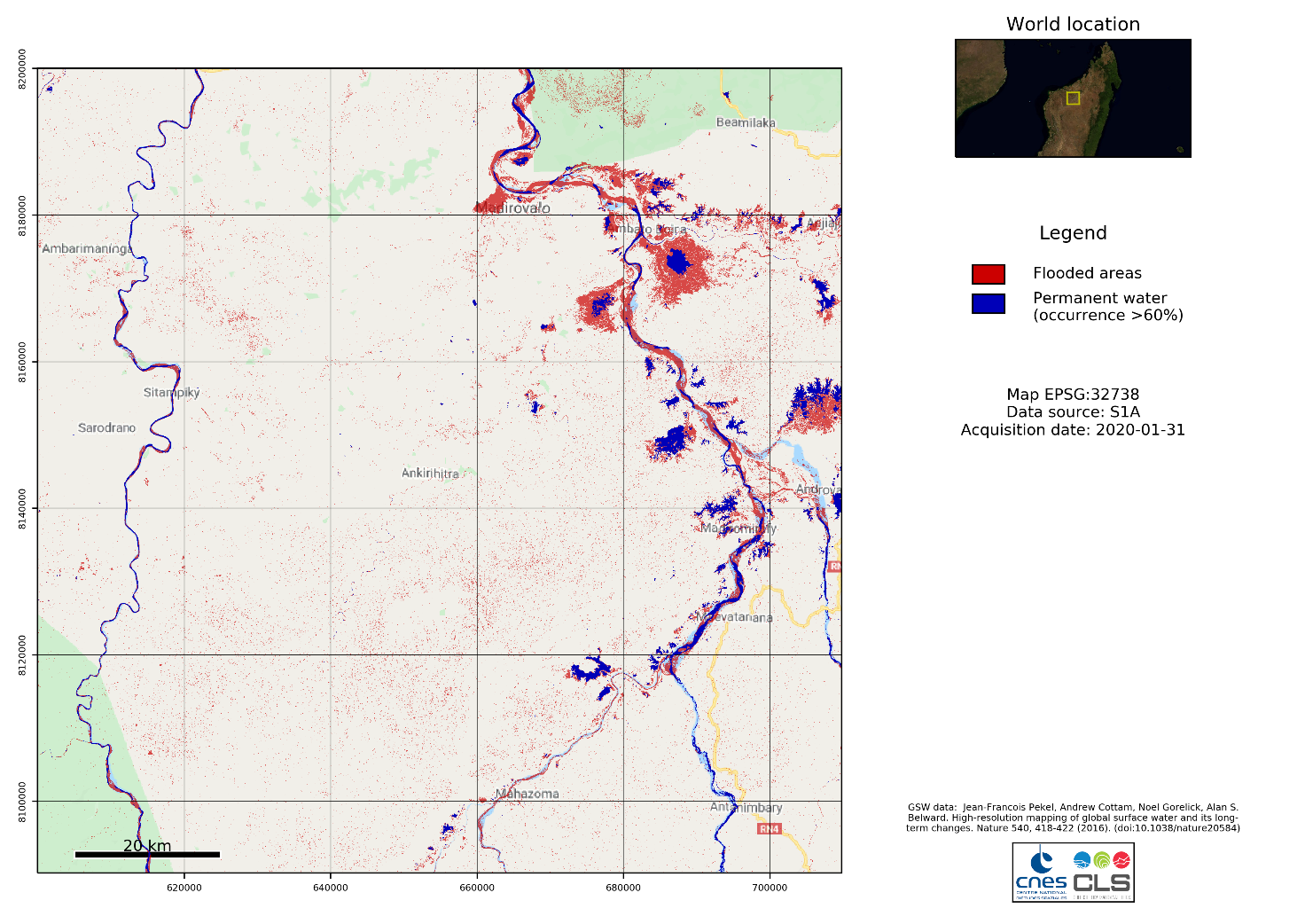
Figure 2 Systematic report from the Seewater platform: inundation extent map for the 31/01/2020 event in Madagascar
Actors and methodology
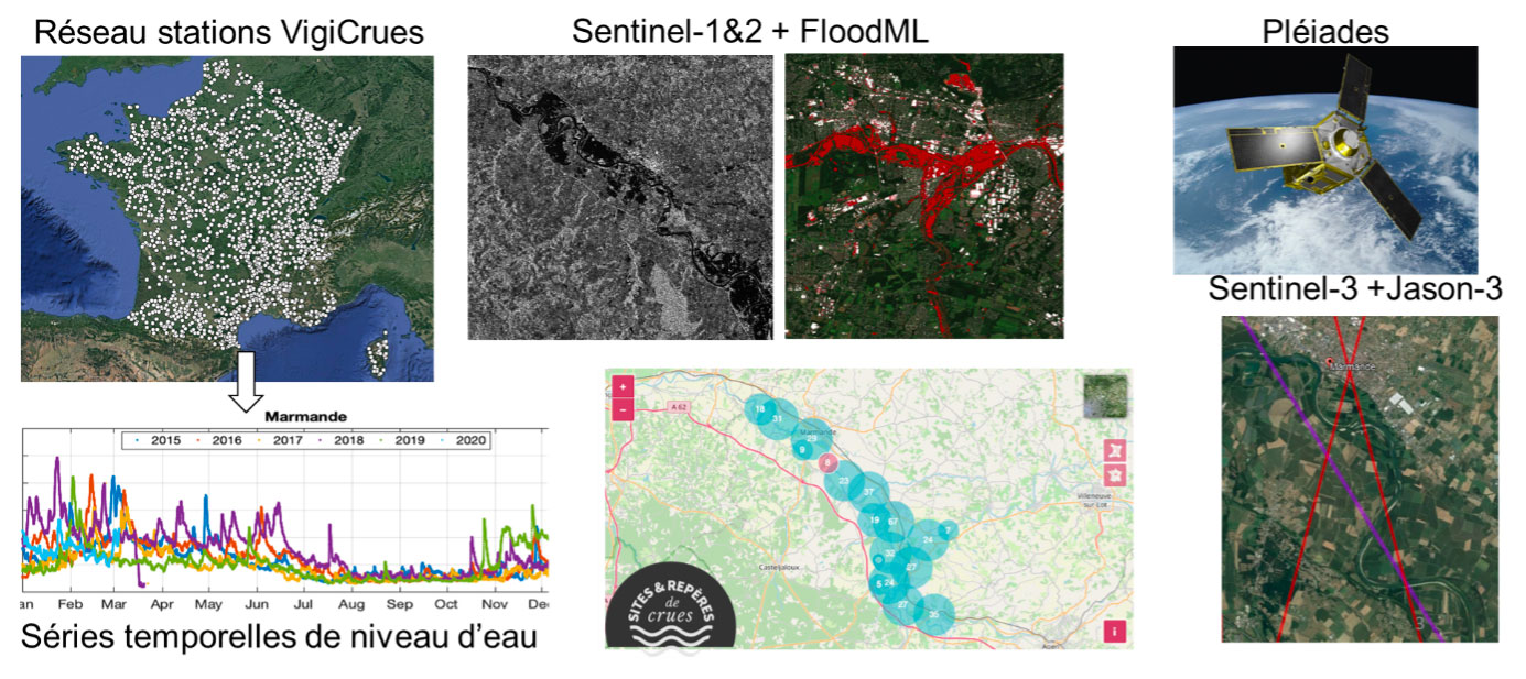
- VorteX.io provides for FloodDAM an innovative and intelligent solution for monitoring, measuring and alerting populations near these 13,000 non-equipped rivers, using non-invasive remote sensing instruments based on a compact in-situ altimeter. It provides in real time, with high frequency and with an accuracy in the centimeter-range, water level measurements of hydrological systems. This first release of the compact altimeter system can be embedded on drones or considered as in-situ fixed stations. It combines a LiDAR sensor, precise GNSS positioning, attitude measurements, a lightweight camera and real time communication system in order to provide accurate water levels and other key parameters (i.a. water extent, surface speed).
- In addition, Predict Services established itself as an expert and an emergency response in the prevention of natural risks, helping municipalities, companies (such as insurances) and individuals to make the right decisions in the face of the crisis: before, during and after. Throughout the project, Predict Services captured user-needs to be implemented in the pre-operational service (cf. Results section below).
- In order to provide accurate information to local entities in the case of a flood event, the CERFACS offers short term prediction and event re-analysis based on computational fluid dynamics (CFD) modeling capabilities. The CFD modeling capability of the tool relies on open-source software for resolution of hydrodynamic partial differential equations (PDEs) with the open TELEMAC-MASCARET suite of solvers. The data will be provided by the in-situ service of vorteX.io as well as the French hydrometeorology service (SCHAPI) in order to extend the time-coverage over the given zones. The assimilation of in-situ data in the TELEMAC 2D numerical solution will provide a re-analysis of flood heights over the past period and short-term forecasted key flood-parameters with an associated uncertainty available for decision support systems when run in near real-time (with a drone real-time mapping for instance).
- Finally, Airbus DS provides to FloodDAM very high-resolution (VHR) imagery, coming from both optical- (Pleiades) and radar-based (such as TerraSarX) platforms. This helps to improve both spatial resolution and reactivity, increasing the potential to output instantaneous flood maps over affected regions world-wide.
In order to process this imagery data, the processing tools of FloodDAM are based on Machine Learning models trained on the available data. These models will permit the FloodDAM project to output automatically generated maps. The models will be enhanced using available Digital Surface Models and can moreover be adapted to leverage other sources of information such as future SWOT, airborne SAR or other VHR data.
Application site(s)
- Garonne, France
- Mississippi, USA
- Seine, France
- Ebro, Spain
- Betsiboka, Madagascar
DATA
Satellite
High resolution (HR) Copernicus imagery providing global coverage to all test sites:
- Optical (Sentinel-2)
- Radar (Sentinel-1)
- Altimetry (Sentinel-3)
Very high resolution (VHR) imagery provided on-demand on select zones by our partner Airbus DS:
- Radar (TerraSarX)
- Optical (Pleiades)
Other
- Local in-situ water gauge station networks (provided by Vortex.IO)
- Bathymetry and hydrographic data
- Land-cover maps (provided by CNES)
- Local VHR topography and Digital-Elevation-Models (DEMs)
RESULTS - FINAL PRODUCTS
The project delivered in July 2022 the FloodDam platform: https://datastore.cls.fr/seewater-flooddam
Accessible via an account and password, it provides the following:
- A flood alert service leveraging the use of country-wide in-situ station networks to be used as an early-warning system. This service was operated by Predict Services with data coming from in-situ stations set-up by vorteX.io and the French hydrometeorology service (SCHAPI)
- An automated flood mapping system based on both Copernicus Sentinel- and VHR TerraSarX- as well as Pleiades-data. The mapping system is based on the CNES collaborative Ground segment (PEPS) that gives access to Sentinel-1, -2 and -3 data and embeds the image processing components (cf. Figure 1).
- Flood risk indicator maps based on time-series processing on selected sites giving access to local entities for urban planning and land use. These maps simulate varying water-levels and take into account local CFD simulations assimilating in-situ data and 2D flood-maps topography and hydrography data.
Predict Services generated a flood risk map based on the maps provided by CERFACS as shown in the figure below:
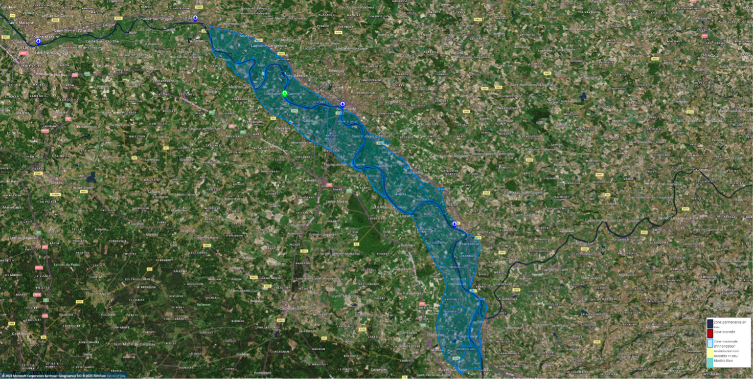
Figure 3 Maximum flood zone provided on the Garonne Marmandaise (44.50125°N, 0.15562°E) - Seewater visualization platform © Predict Services
In order to finalize these developments, thanks in particular to a digital twin of warning system and mapping of flood risks on a local and global scale, the project continues from 2023 under the name FloodDAM-DT, still under the SCO label.
At the end of the FloodDAM-DT project, the machine-learning models developed will be made available as free software.
References
| FloodDAM on GEO Knowledge Hub, a long lasting digital repository created by the Group on Earth Observations: https://doi.org/10.60566/a2gv9-95910 |
Related SCO Projects
Project news
- 18/01/2021: 1st COPIL for FloodDAM
- 09/06/2021: Video (YouTube, in French) FLoodDam, optics and radar against flooding : extract from the First Quarterly of the SCO France, where the project is presented under the angle "use of satellite data" followed by a progress report
- 08/09/2021: FloodDAM: on the way to the 2nd stage