

FLAude

Increased resilience to flooding
Project completedThe FLAude project delivered the FORO portal to the Aude territory in early September 2021. This is a demonstrator on the Aude territory in public access with 2020 data. It is first and foremost an educational tool for understanding the phenomenon, understanding incentive actions and how to integrate them into regulatory territory projects.
OVERVIEW
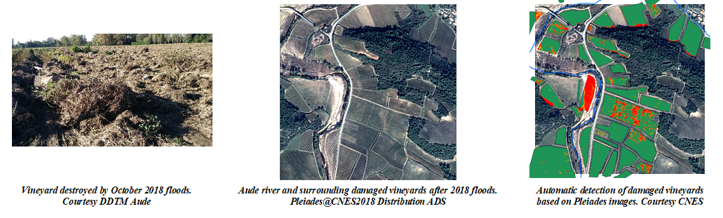
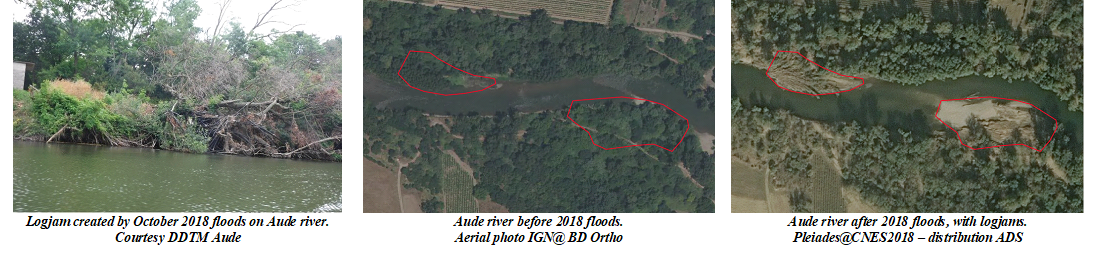
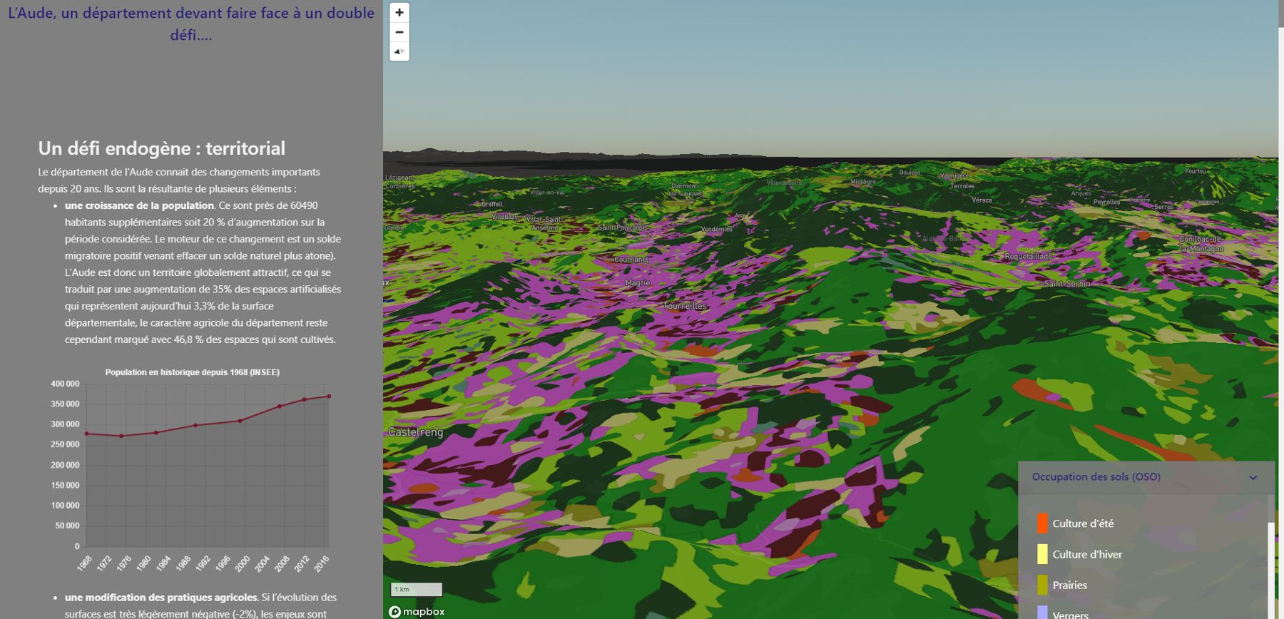
Following the disastrous floods that occurred in October 2018, Aude French department has become a pilot territory for the use of satellite images following hydro meteorological disasters, contributing to the development of territories more resilient to extreme events. Since the end of 2018, a collaborative work, anchored in reality, has been carried out between the departmental directorate for territories and sea (DDTM Aude) and CNES, through in-depth analysis of extreme hydro-meteorological events, aiming at developing a future Flood Observatory for Resilient Occitanie.
The Copernicus Climate Change Service (C3S) wanted to contribute to the Spatial Climate Observatory (SCO) by contributing to a demonstration case based on experience gained in the Aude region. The aim is to enhance existing methods and results by using data and products from the C3S Climate Data Store, the Copernicus Emergency Management Service (EMS) and other data. In addition to assessing the impact of flooding at local level, the aim is to improve knowledge of extreme hydrometeorological events on a regional scale and to refine climate projection methods. Based on specific cases in the Occitanie region, the aim is to provide input for regional decision-making and planning tools designed to limit the impact of climate change.
The Flood Observatory for Resilient Aude and Occitanie (FORO) decision-support tool has been created to capitalize on the results of this project and promote interaction between the various stakeholders, with a view to contributing to a more resilient Occitanie region.
FLAude builds on previous work devoted to the Aude département to extend its scope, duration and coverage, by examining the impacts and adaptations required in the Occitanie region, as well as medium- and long-term climate projections. The results and associated good practices will benefit the Flood Observatory, other services and departments in the regions and departments (DDTMs, DREALs, DEALs, EPCIs), as well as players in the Satellite Applications Plan of the Ministry of Ecological and Solidarity Transition. The reproducibility of the service at European and even global level is ensured through the use of tools and data sets and especially new C3S climate data sets.
FLAUDE has made it possible to create algorithmic building blocks and obtain preliminary results that have subsequently fed into FORO. This programme contributes to understanding extreme hydrometeorological phenomena and developing risk prevention and reduction methods for use by local decision-makers. The medium-term objective has been achieved through the FORO platform, which will be deployed in new pilot areas in 2023 to provide planning tools for specific catchment areas. The longer-term objective is to be able to meet the needs of regional and local authorities affected by extreme hydro-climatic events in France (metropolitan and overseas) and abroad.
To ensure the relevance of the FLAUDE demonstrator, the CNES-led project team maintains close links with :
- local, department and regional users, led by DDTM Aude,
- Météo-France as a key partner for climate expertise in France and experience in using C3S data to make the service reproducible, and
- Public policy EXPERTS and academics (SGEvT/Université Toulouse 2 Jean Jaurès) in order to guarantee the suitability and acceptability of these tools by authorities and decision-makers.
New European or global products supplied by C3S will enable long-term trends in flood risk to be studied and projections for the future to be made. These products will be evaluated using reference data from Météo-France, and will thus be able to help policy-makers make better planning decisions for the future.
Application site(s)
- Aude department, France
DATA
Satellite
- French satellite Pléiades (70 cm resolution)
- European satellites Copernicus/Sentinel-2 (10m resolution) and Copernicus/Sentinel-1 (10m resolution)
- Historical Spot and Pléiades archive (Spot World Heritage)
- Other free and open satellite images data sets: Landsat
Other
- C3S data and models: ERA-5 Land and/or UERRA
- EuroCordex projections
- Météo-France data and models on DRIAS portal
- Product Coméphore, Météo France
- SWI-SIM2 soil moisture index, Météo France Climascope
- Intense events, Météo France
- Departure from normal temperatures, Météo France
- Climate projections, Météo France
- Space data portals: PEPS, IR DataTerra (THEIA, AERIS, ...), etc.
- Copernicus Services: C3S, EMS (RMS, RRM, EFAS), CAMS, Land
- Crop orientation, CNES
- RGE ALTI Digital Terrain Model (5m resolution), IGN
- "Intense Rain Runoff Indicator (IRIP), INRAE
- Map of soil types, ESDAC/INRAE
- Flow zones ExZEco, CEREMA
- Aquifer System Boundary Data Base (BDLISA) - Karst areas, BGRM
- Network development and persistence index (IDPR), BGRM
- BD TOPAGE ®, IGN and French Biodiversity Office
- BD HAIE ®, IGN
- BD TOPO ®, IGN
- BD ORTHO®, IGN
- Route 500 ®, IGN
- Graphic Land Register (RPG), IGN
- OSO land use map, CESBIO
- PPRI zoning, Direction Départementale des Territoires
- Numerous territorial data sets: land use maps, population density maps, etc.
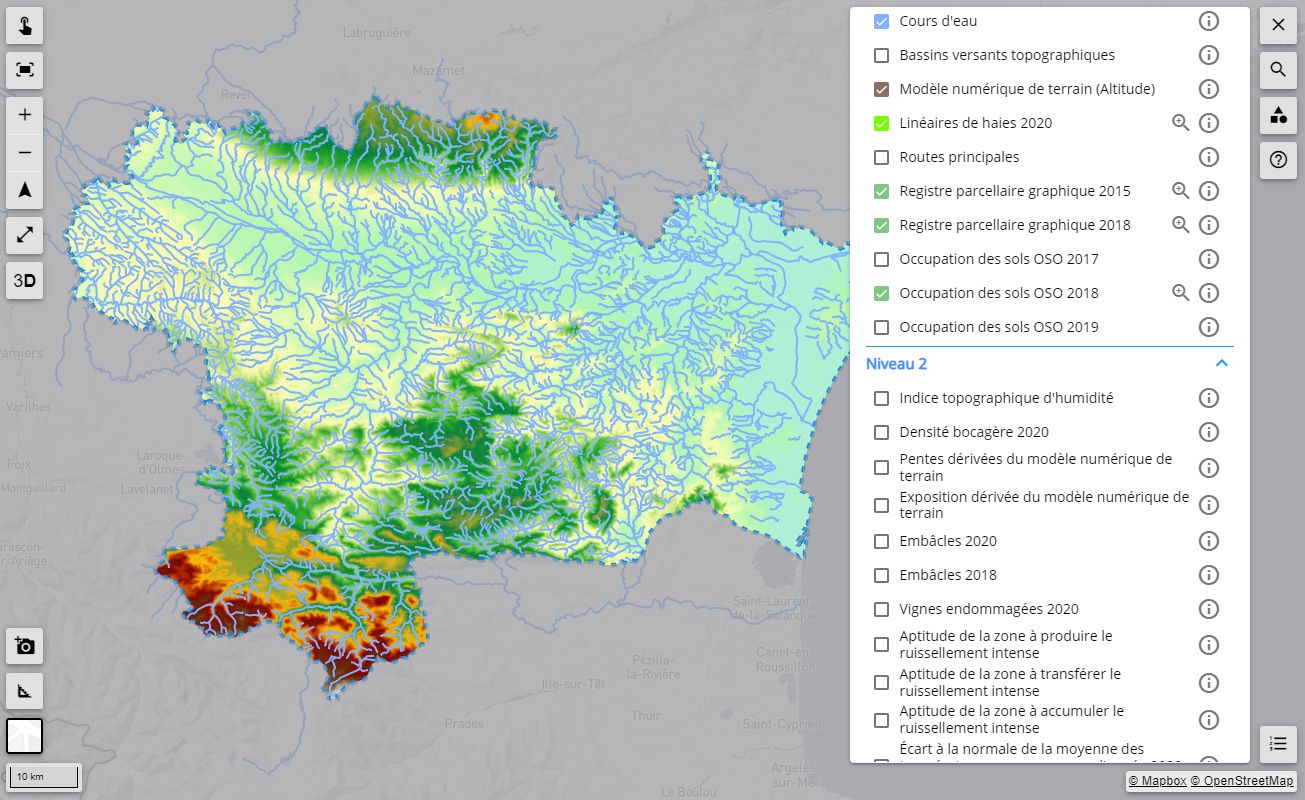
RESULTS - FINAL PRODUCTS
Delivered to the Aude department at the beginning of September 2021, the FORO portal has since been accessible to the general public.
This is a demonstrator on the Aude territory with public access to 2020 data. Above all, it is an educational tool to help people understand the phenomenon, understand incentive measures and how to integrate them into local regulatory projects.
The demonstrator includes :
Summary of issues relating to intense runoff
|
👉 Provides a summary of the condition of an area with regard to the risk of intense runoff. It provides a few key figures on the potential impact of intense runoff, as well as a few levers for action to help combat this phenomenon. |
|
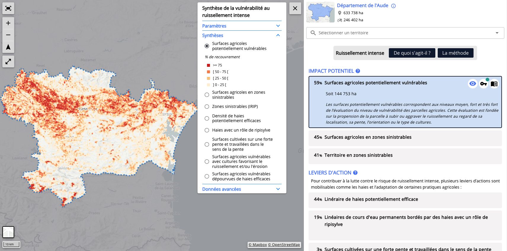
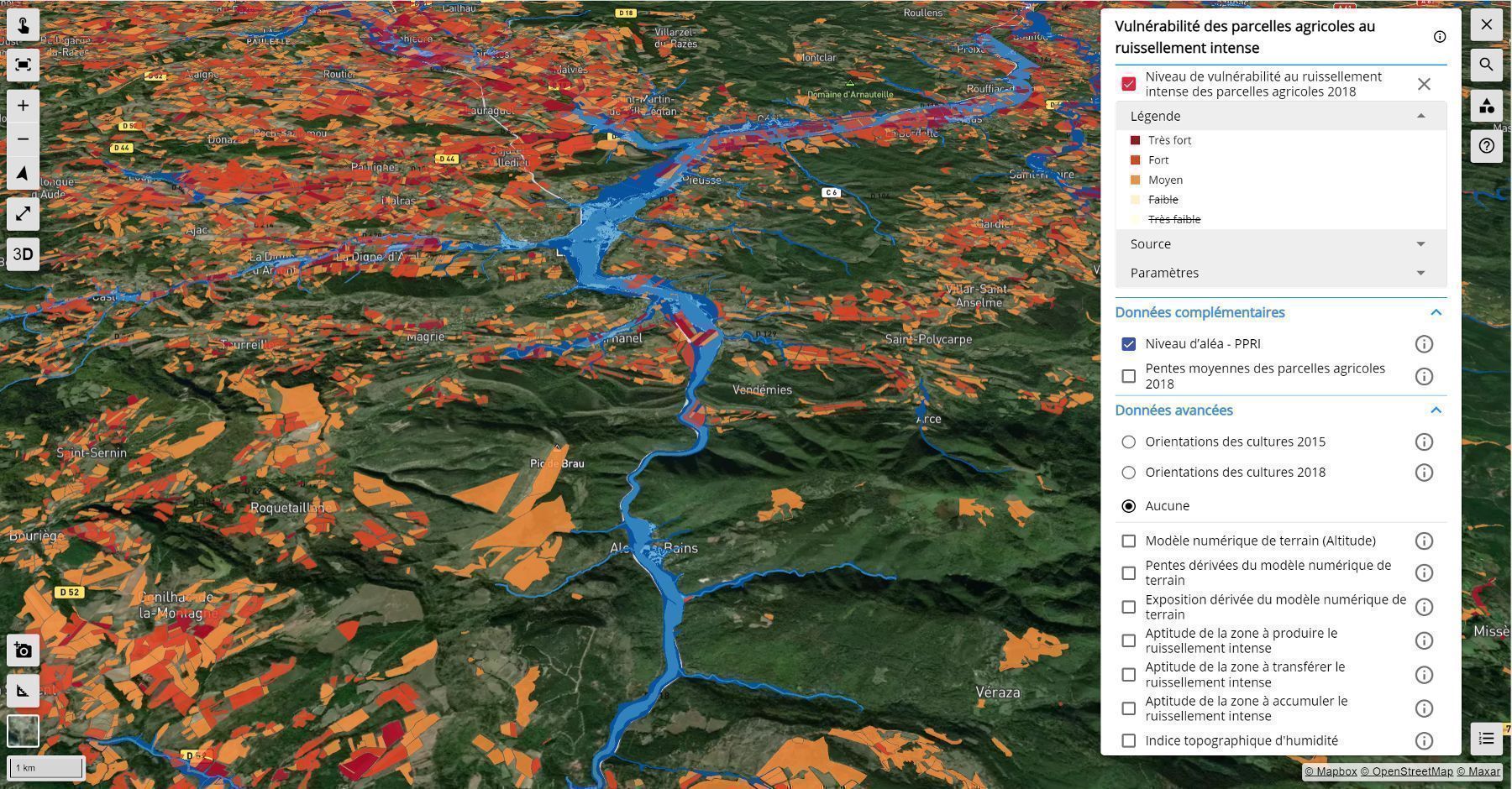
Vulnerability of agricultural plots to intense runoff
|
👉 Reports on a multi-criteria analysis of the vulnerability of agricultural plots to intense runoff. The tool available on the platform makes it possible to consult the results dynamically, monitor this vulnerability and locate priority areas for action. |
|
It also offers the possibility of visualising the orientation of crops identified using a remote sensing processing chain developed by the CNES, which uses very high spatial resolution satellite images (Pléiades) if available. Orthophotos can also be used to calculate these orientations.
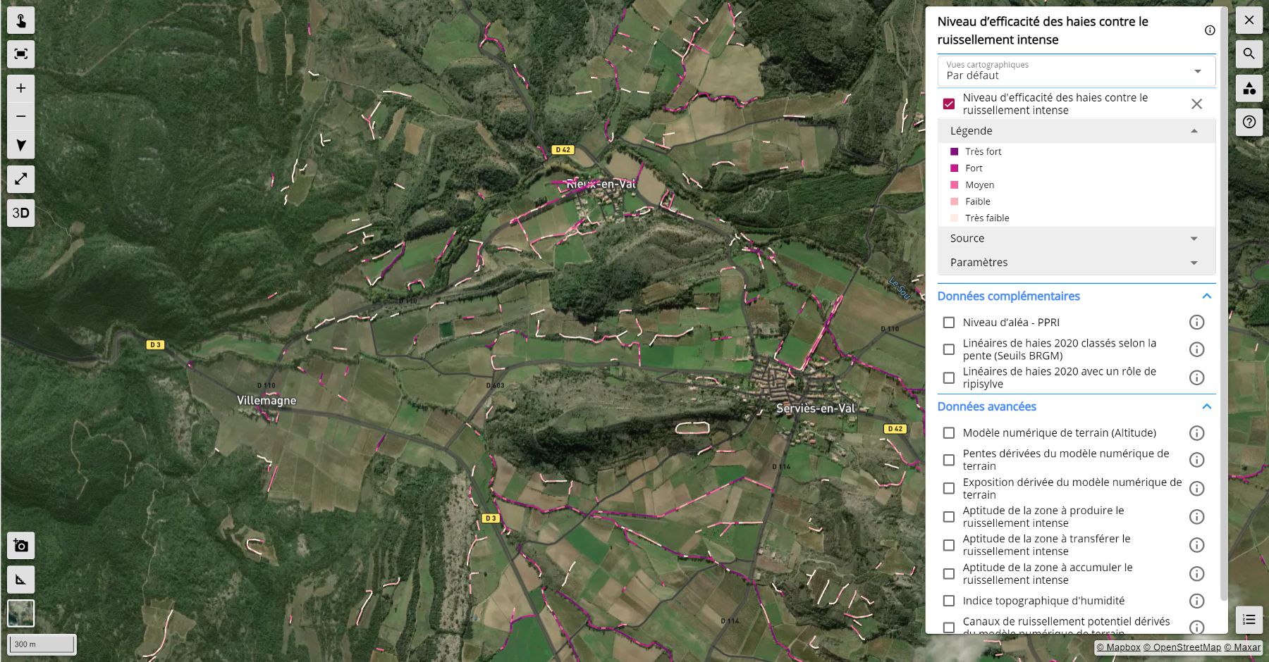
Level of effectiveness of hedges against intense runoff
|
👉 This assessment is based on a cross-referencing of several sources of information such as slopes, the IRIP intense runoff indicator and other plans derived from a digital terrain model. |
|
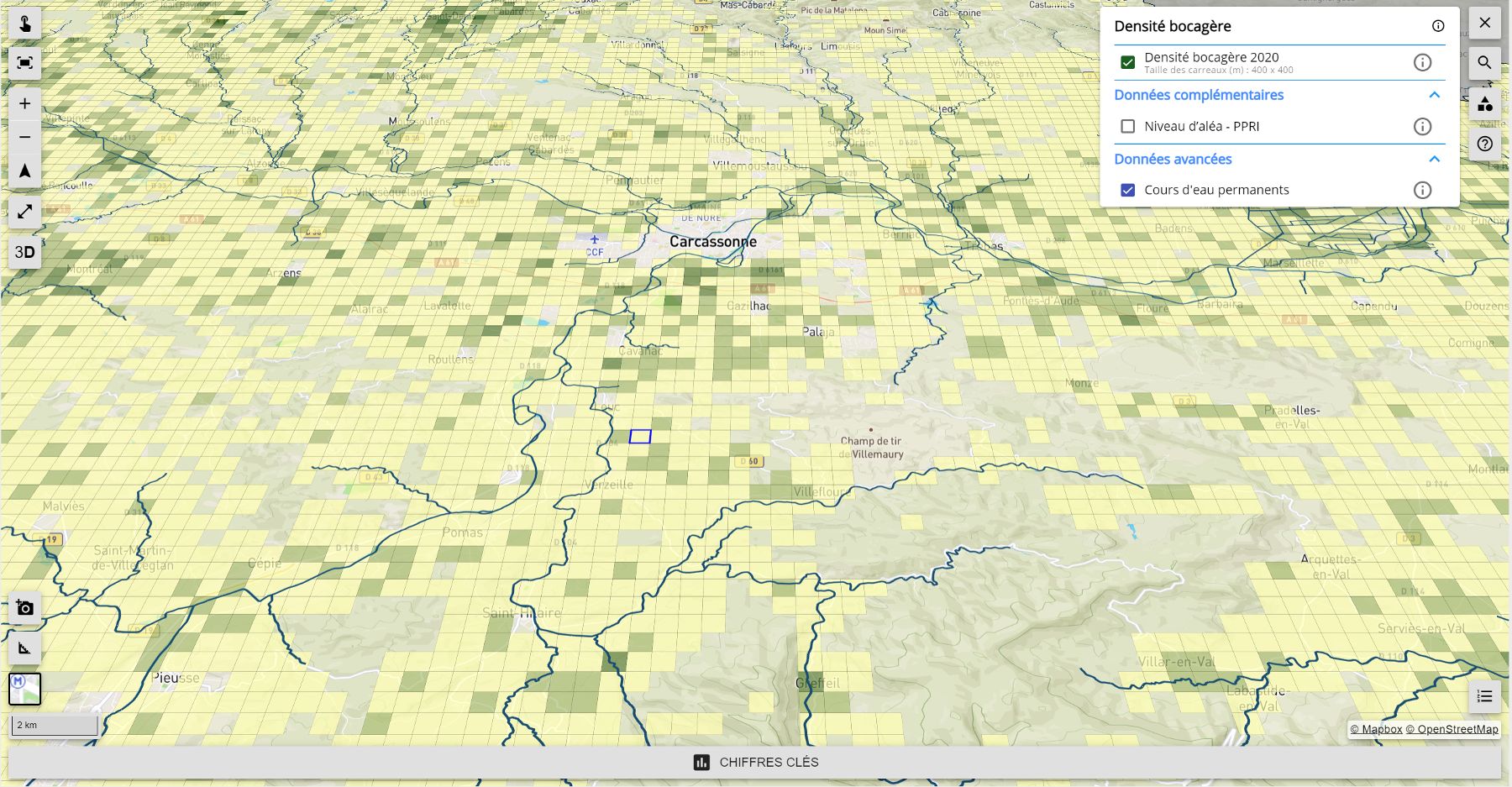
Bocage density
|
👉 Presents bocage density, which is defined as the ratio between the linear length of hedgerows and the surface area under consideration. This ratio is a good indicator of the state of the bocage. The data used for this indicator comes from the national bocage monitoring system (produced by ONCFS and IGN). |
|
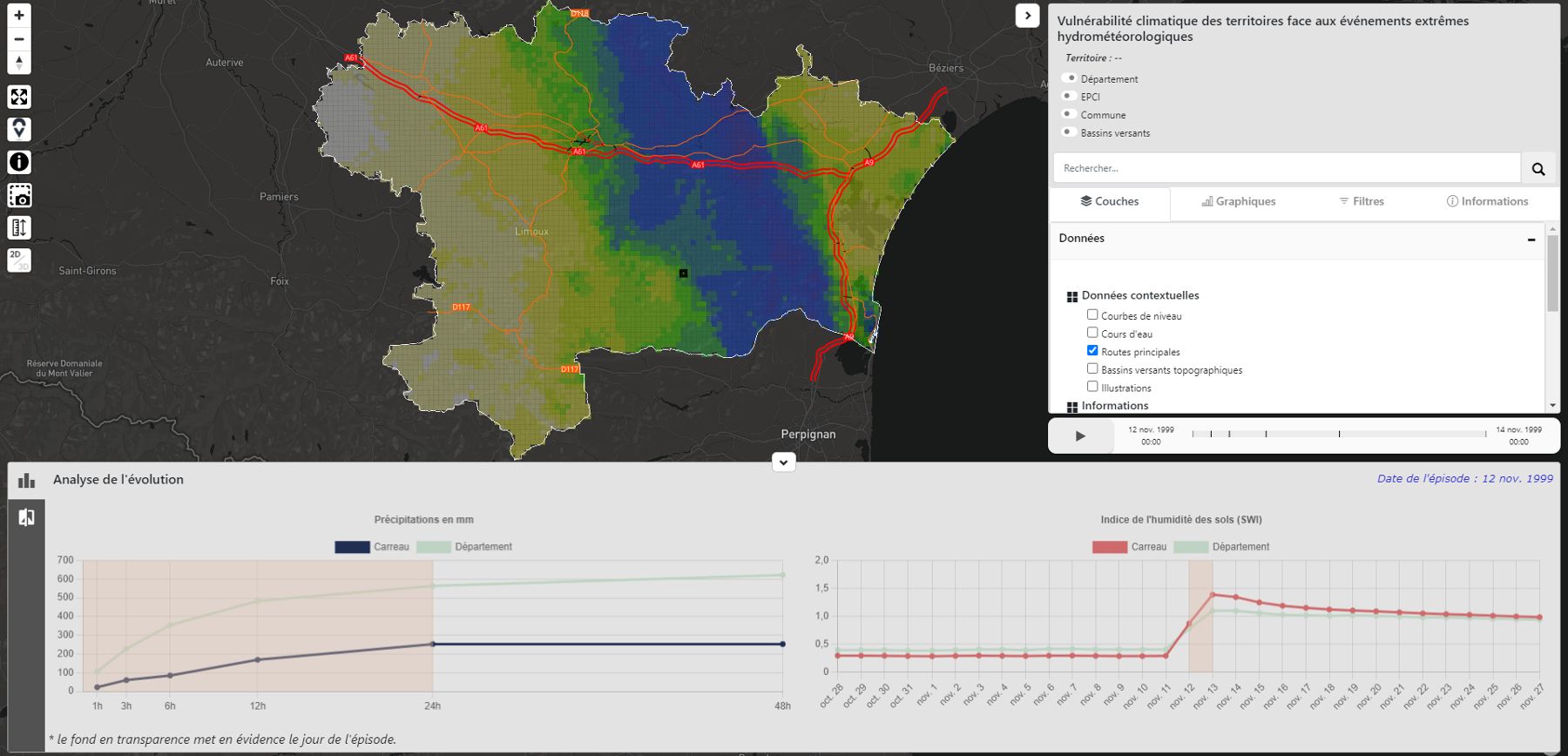
Intense rainfall hazard history
|
👉 Tool for displaying and analysing data collected during extreme rainfall events observed in the past in the region. |
|
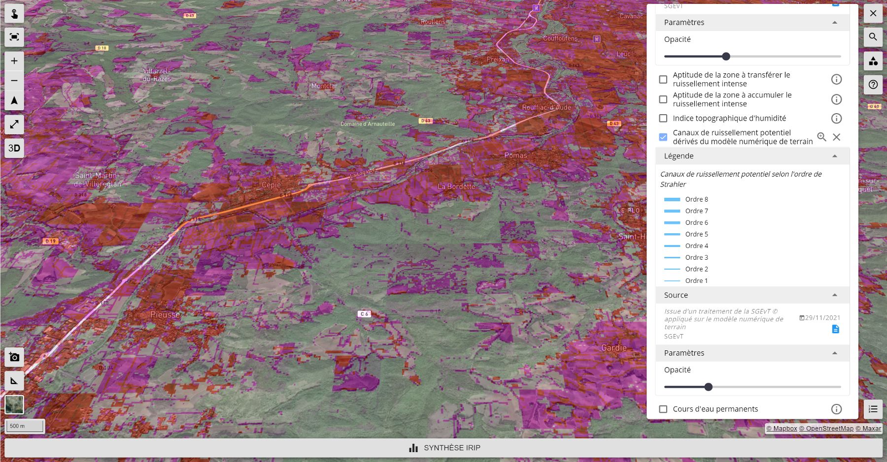
Locating areas of intense runoff (IRIP method)
|
👉 Tool for identifying the areas that produce runoff, the flow transfer axes and the accumulation areas in the event of intense runoff. |
|
Tool for viewing satellite images and cartographic data
|
👉 Tool for viewing all the Pléiades satellite images and cartographic data used in the FORO platform. |
|
A cartographic account of the climatic context and the issues associated with intense runoff in a given area
|
👉 This tool provides a visualization environment for interactive learning on the problem of intense runoff in the Aude département. |
|
References
| FLAude on GEO Knowledge Hub, a long lasting digital repository created by the Group on Earth Observations: https://doi.org/10.60566/3fd26-ebd80 |
Related Projects
SCO ATTEST
SCO FloodDAM Garonne
SCO ASGARD
PROJECT NEWS
- The deployment of the FORO portal has been taken over by the AFPCNT (French Association for the Prevention of Natural and Technological Disasters) for gradual deployment in the 23 departments of the Mediterranean Arc.
- 22/11/2022: Flood resilience: FORO is open access
- 14/02/2022: On the occasion of the Occitanie 2022 Employers' Forum, the DDTM of Aude illustrated the skills in geomatics and earth observation through the FLAude project and its FORO tool. This forum was organised by the Ministries of Ecological Transition, Territorial Cohesion and the Sea to showcase the professional opportunities within the services and operators of this ministerial cluster in Occitania.
- 31/01/022: European data at the heart of SCO projects, including how the FLAude project uses Copernicus data
- 08/09/2021: FLAude: the FORO tool in the hands of professionals!
- 23/02/2021: Focus on FLAude