SCOInternational
57SCO-labelled projects from 2019 to 2022, including 50 by SCO France
Useful linksSCOlutions to
- #1-SDG13: Fighting Climate Change
- #2-SDG15: Terrestrial Biodiversity
- #4-SDG6: Water: access for all and sustainable management
- #5, SDG17: Revitalize the global partnership for sustainable development
Key wordsSustainable urbanization, heat islands, green spaces, vegetation, ecosystem services, flooding, air pollution
SCOlutions to Sustainable Development Goals - #3, SDG11

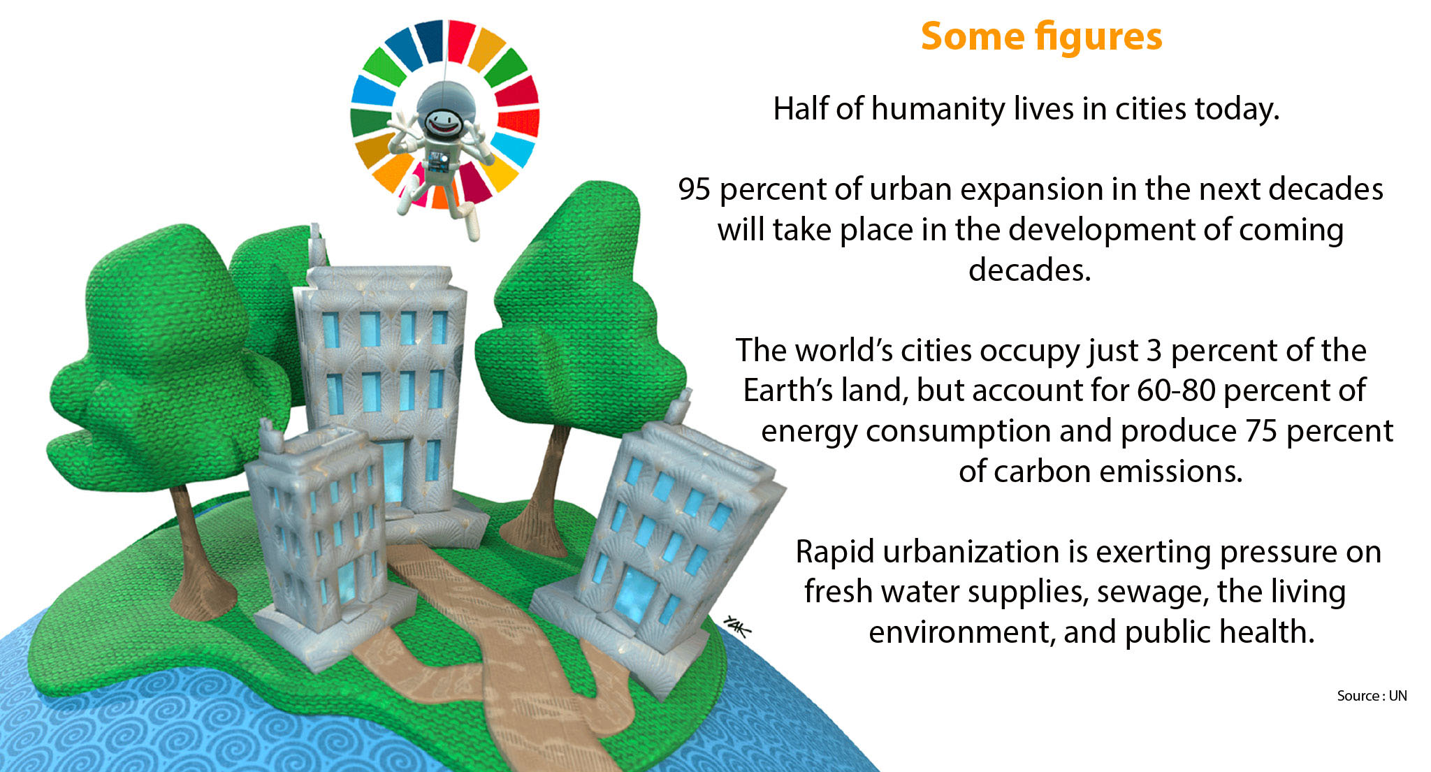
While 55% of the world's population is currently considered urban, the World Bank estimates that the urban population will double by 2050, reaching a level where almost 7 out of 10 people will live in cities! These demographic estimates illustrate the major societal challenges that our generations and those that follow will have to face. Thoughts about urbanization, its consequences and its organization are at the heart of current concerns, especially when acknowledging the effects of climate change. Welcome to the SCOlutions to the SDG11, especially in France where SCO is a partner of France Sustainable City (France Ville Durable).
For the record, Space for Climate Observatory (SCO) is in line with the Paris Agreement and the 2030 Agenda. By gathering international space expertise alongside science, particularly in favour of vulnerable territories, SCO is intended to become an essential tool for informing decisions on adaptation and resilience to the consequences of climate change.
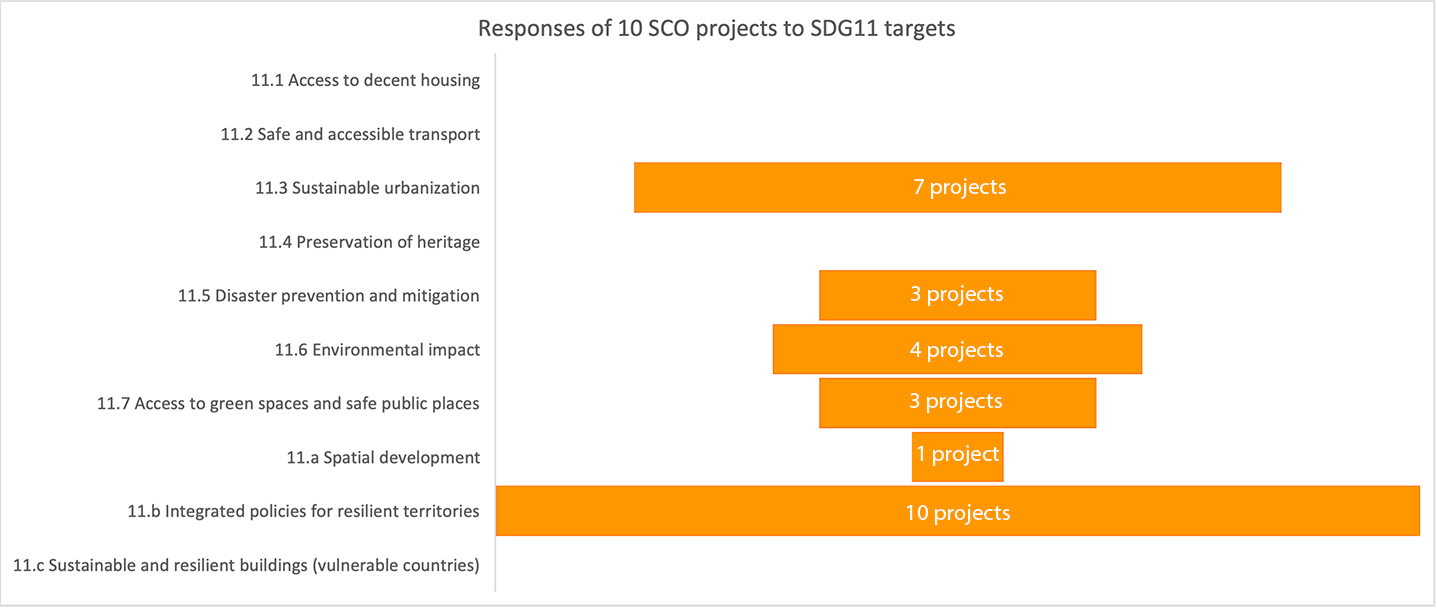
18% of SCO projects address urban adaptation.
SCO and SDG11 “Make cities inclusive, safe, resilient and sustainable”
Optical imagery, including 3D, radar imagery, thermal and atmospheric data, 10 SCO projects use a variety of satellite data to feature urban fabric and analyze its vulnerability through different factors. All of them respond to an overall objective of the SDG11 to implement integrated policies for resilient territories.
This starts with sustainable urbanization, the third target of SDG11. In France, {Sat4BDNB} project is set to become a major decision-making tool for implementing the recent Climate and Resilience national law, including the "Zero Net Artificialization" objective. Why? Because it is setting up nationwide indicators of urban overheating, associated vulnerability of the population and assessment of mitigation strategies, including in terms of cost. Results will be freely available in the National Buildings Database (BDNB).
Among the main impacts of climate change, already felt by billions of urban citizens around the world, cities are becoming particularly vulnerable to increasing heat waves, both in duration and intensity.
While the building sector must adapt construction techniques and materials - and will be able to rely on {Sat4BDNB} for this - vegetation is one of the main levers for cooling the air and maintaining a healthy living environment in cities. {Green Urban Sat} project is generating a geospatial database with a detailed description of vegetation which, by facilitating the evaluation of the ecosystem services rendered by greening, helps to define the best vegetation strategies. {City Explorer}, supported by the European Space Agency (ESA), adopts the same philosophy by extending the scope of ecosystem services to compare the relative benefits of different locations of new green spaces in the urban environment.
Still on the subject of overheating, cities have to deal with the phenomenon of urban heat islands (UHI), where night-time temperatures remain stifling. SCO projects such as {Thermocity} and {SatLCZ}, both of which are operational and available, make it possible to identify and feature areas which are most at risk, in order to inform decision-makers about the measures best suited to their context. And the thermometer is clear: mercury is rising in small towns and cities alike. In fact, SCO projects are testing their innovations in many French cities such as Lille, Toulouse, Paris, Marseille, Montpellier, Strasbourg and Nancy, as well as Rayong in Thailand.
In the field of disaster prevention and mitigation, the fifth target of SDG11, {FloodDAM} project automates a flood warning service associated with a modelling of possible risks. To ensure that its method is widely used, it is testing its development on various rivers in France, Spain, USA and Madagascar. With a similar objective, {BAND-SOS} focuses on the forecasting of cyclonic flooding and the associated societal risk in the Bengal Delta.
Less visible and dangerously insidious, air pollution is becoming a public health problem, especially in urban areas. According to the World Bank, in 2016 nearly 90% of city dwellers breathed unhealthy air. The {AEROLAB SPACE} project is developing a platform for monitoring greenhouse gases, whose maps, indicators, statistics and trends will provide important decision-making support, focusing on air quality, the sixth target of SDG11.
To go further:
- The unrivalled advantages of satellites and 3D imagery to meet the challenge of urban adaptation, a result shared during a joint interview with CEREMA, Airbus DS GEO and CNES, partners in SatLCZ project;
- The challenges of the transition to sustainable cities and the contribution of space to achieve this according to Julien Hans, Director of Energy and Environment at the Scientific and Technical Centre for Building (Centre Scientifique et Technique du Bâtiment CSTB)
- SDG11 presented by the UN