

Applications Toolbox
Below are the tools developed and delivered by the SCO projects.
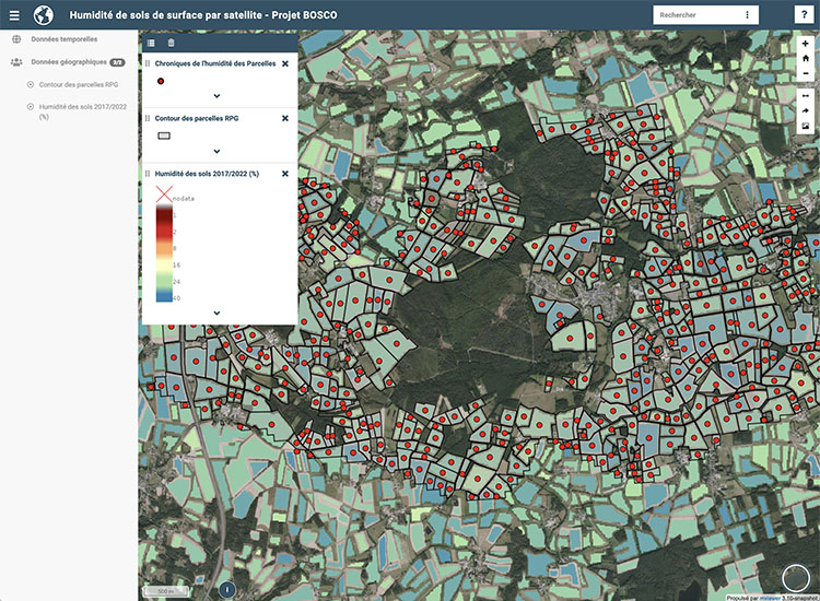
Satellite surface soil moisture
Developed in Brittany, where geology makes water supply dependent on surface water, BOSCO lays the foundations for a spatial observatory of soil water content.
The interface displays three key pieces of information at very high spatial resolution (plot) and temporal resolution (2-3 days), which are crucial for farmers and water managers: surface moisture (first 5 cm of soil), root water content (one metre deep) and recharge (or water flow) towards the water table.
🟢 Free access
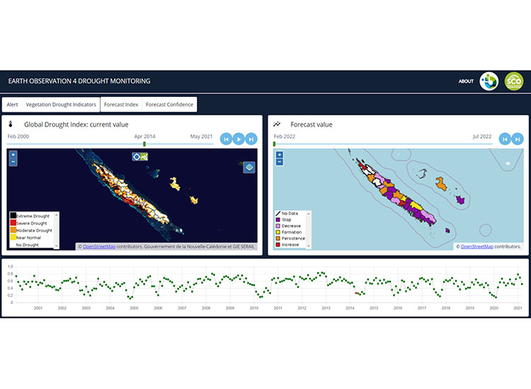
A tool for characterising, monitoring and forecasting drought on a regional scale
An information display and distribution platform developed by InSight, the indicators put in place provide institutions with an objective, up-to-date, spatialized and temporal response to the drought phenomenon.
Developed in New Caledonia, the tool also helps farmers to manage their crops in a rational way, by enabling them to monitor the situation as closely as possible, in line with environmental conditions and changes in them. InSight is now working on extending the tool to other territories and extending its functionalities.
🔵 EO4DM is a commercial service and requires an account and password.
Global flood alert
A Franco-American cooperation between CNES and NASA to design a digital twin of the Earth system based on the water cycle, FloodDam-DT has delivered an automated service to reliably detect, monitor and forecast floods on a global scale, including an estimate of the associated socio-economic risks.
🟢 All products from the treatment chain at the two study sites (Garonne in France and Ohio in the USA) are available on the open platform hydroweb.next (enter FloodDAM in the search box).
🟢 The FloodML tool generating flood mapping from satellite data is open source on the CNES github.
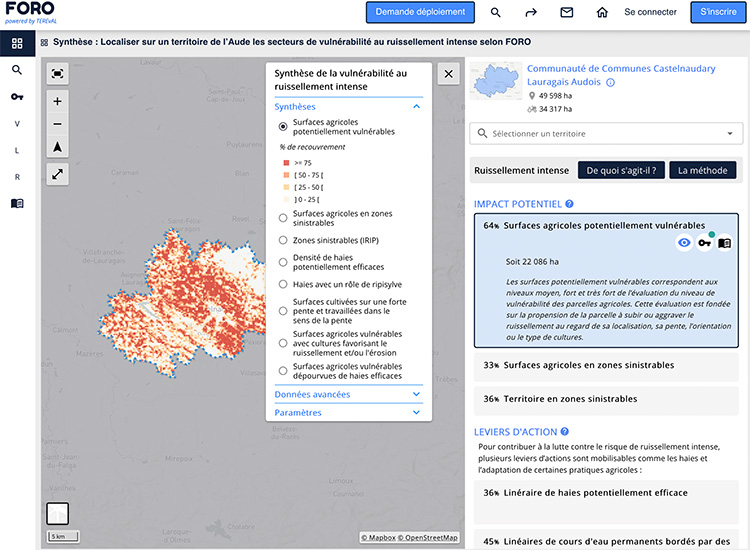
Improving resilience to extreme hydro-meteorological events
Developed as part of the FLAude project, FORO uses satellite observation to improve the resilience of areas to the risks of flooding caused by intense run-off.
A genuine decision-making tool, FORO offers interactive maps to pinpoint problem areas and the levers for action. FORO is gradually being rolled out across the 23 departments of the Mediterranean Arc.
🟢 Free access to results for the Aude department
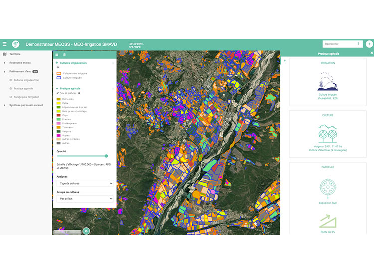
Monitoring irrigated plots and their crop rotation
MEO-Irrigation is a web mapping interface that can be used to extract quantitative indicators to monitor crop irrigation and assess the total surface area irrigated in order to anticipate water requirements and tensions. Working with Sentinel-1 radar and Sentinel-2 optical data at plot level, the system aggregates its data to produce statistics and analyses at commune, canton and even catchment level.
MEO-Irrigation thus completes the MEOSS WaterManagement range of services.
🔵 A commercial service, access requires an account and password.
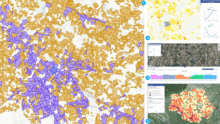
Smart water management in agriculture using satellite technology
The culmination of several SCO developments merged into the EO4AgriWater project, MEO-WaterManagement is a decision-making tool that combines satellite imagery, data science, and artificial intelligence to ensure sustainable water resource management in the agricultural sector. It provides operational indicators on plant drought, irrigation practices, crop types, and water availability in reservoirs. The tool enables public and private managers to better understand local developments and dynamics in order to anticipate critical situations and optimize water use.
🔵 Commercialized service
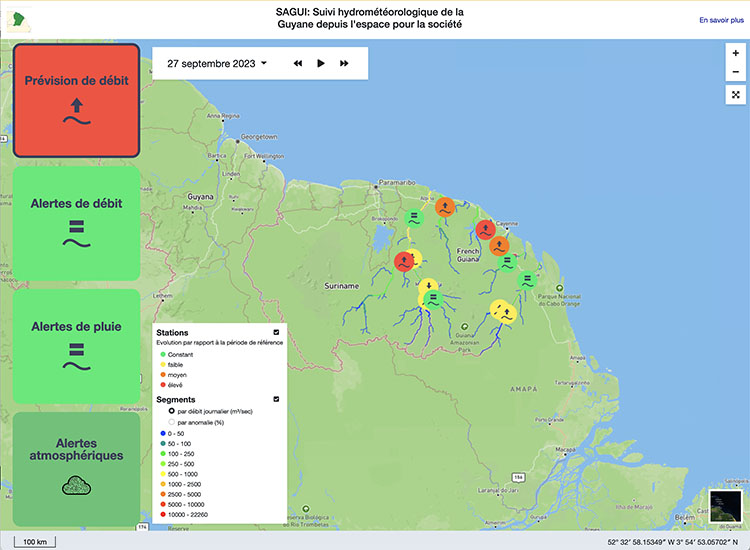
Hydrometeorological monitoring and forecasting
Operational in French Guiana since June 2023, the SAGUI platform offers a hydrological forecasting service based on space altimetry data to monitor river conditions in real time and help with navigability.
In this interface, the fruit of the OpHySE project, the results are displayed on a global map with a coloured representation of the state of the rivers (flows and flow anomalies - i.e. deviations from normal), and several navigation tabs provide differentiated views of the hydro-meteorological indicators flow, rain and air quality.
🟢 Free access
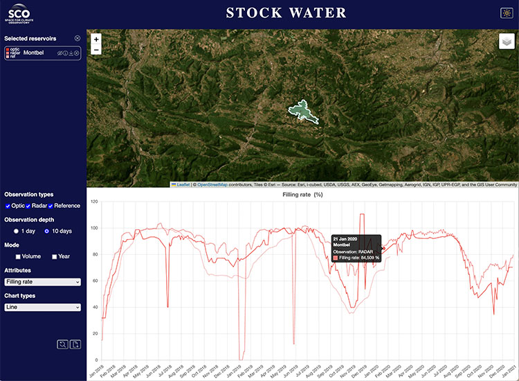
Creating global monitoring of the load on hydraulic dams
An automated satellite-based solution, the Stock Water platform calculates water volumes and the filling rate of dams. It enables inter-annual comparisons and provides a regional water balance report. It currently displays the results of 110 reservoirs monitored for its development over a three-year period.
The DEM-based bathymetry estimator is published under an open source licence.
🟢 Free access