

Applications Toolbox
Below are the tools developed and delivered by the SCO projects.
Global flood alert
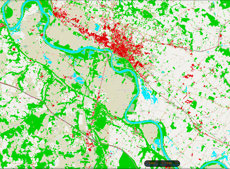
A Franco-American cooperation between CNES and NASA to design a digital twin of the Earth system based on the water cycle, FloodDam-DT has delivered an automated service to reliably detect, monitor and forecast floods on a global scale, including an estimate of the associated socio-economic risks.
🟢 All products from the treatment chain at the two study sites (Garonne in France and Ohio in the USA) are available on the open platform hydroweb.next (enter FloodDAM in the search box).
🟢 The FloodML tool generating flood mapping from satellite data is open source on the CNES github.
Improving resilience to extreme hydro-meteorological events
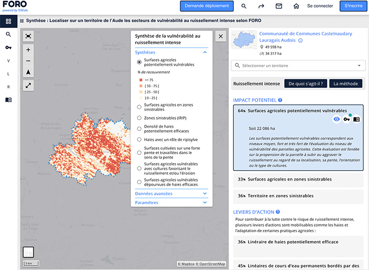
Developed as part of the FLAude project, FORO uses satellite observation to improve the resilience of areas to the risks of flooding caused by intense run-off.
A genuine decision-making tool, FORO offers interactive maps to pinpoint problem areas and the levers for action. FORO is gradually being rolled out across the 23 departments of the Mediterranean Arc.
🟢 Free access to results for the Aude department

Managing hydrometeorological crises in real time
Developed in the Republic of Haiti, the GadeLapli system can be used anywhere in the world. Fed in real time with data from the COSPARIN programme, the 2D/3D platform displays rainfall estimates by analyzing satellite images and potentially flood-prone areas. Real-time support for the civil protection authorities, with the system complemented by the sending of e-mail or SMS alerts and indicators for monitoring the development of extreme hydrometeorological events.
🔵 Service marketed by Predict Services
Automated hydraulic modelling
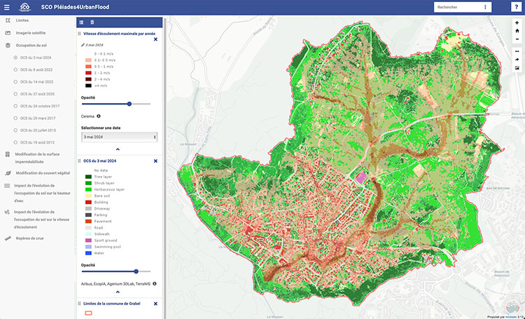
Using very high-resolution monoscopic images from Pléiades and Pléiades Neo satellites, P4UF automatically maps land use (LULC). By applying its integrated hydraulic modelling chain, the application estimates flood risk (water height and speed) and characterises its evolution, taking into account the urbanisation context and climatic events such as droughts or fires. The results are transferable and relate to the Grabels study site (France) for the period 2012-2024.
🟢 Open access
Hydrometeorological monitoring and forecasting
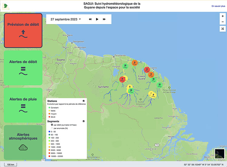
Operational in French Guiana since June 2023, the SAGUI platform offers a hydrological forecasting service based on space altimetry data to monitor river conditions in real time and help with navigability.
In this interface, the fruit of the OpHySE project, the results are displayed on a global map with a coloured representation of the state of the rivers (flows and flow anomalies - i.e. deviations from normal), and several navigation tabs provide differentiated views of the hydro-meteorological indicators flow, rain and air quality.
🟢 Free access
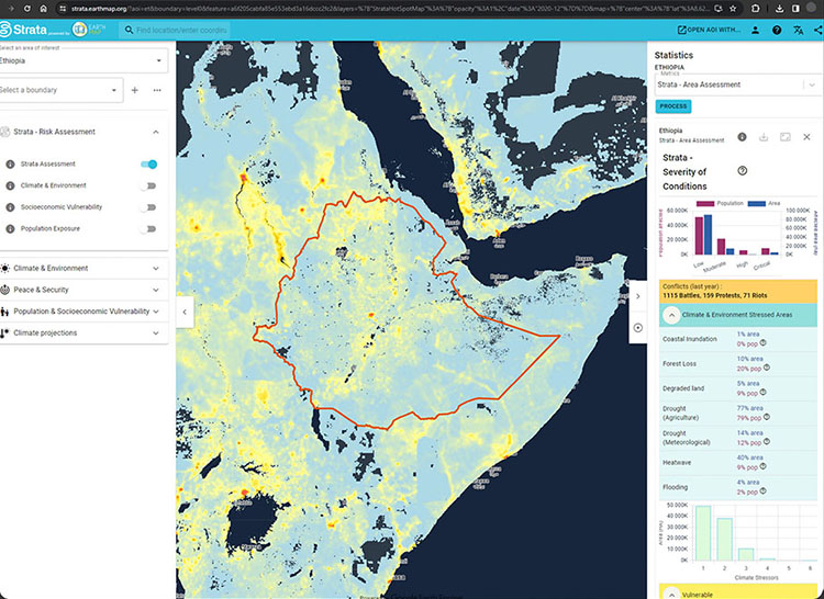
Visualizing complex risks for informed action
The links between environmental change, climate stress, conflict and the vulnerability of populations are complex, and access to data on these subjects is not straightforward. The result of a collaboration between Earth Blox, the United Nations Environment Programme (UNEP) and the University of Edinburgh, Strata brings together data from a variety of sources to see and locate 'hotspots' - those areas most at risk.
🟢 Free access
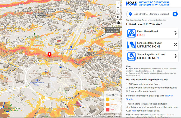
Nationwide Operational Assessment of Hazards for the Philippines
Supported by the Philippine Department of Science and Technology, UP NOAH aims to provide accurate and accessible data on extreme weather events. The NOAH platform offers maps of landslides, flooding and storm surges risk for the Philippines. The ‘NOAH Studio’ tab allows users the option to turn off or on the various hazard map overlays. The downloadable maps and data use the ESRI shapefile format to facilitate the use of existing GIS software.
🟢 Free access
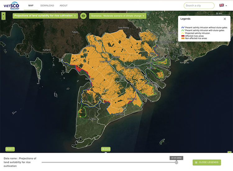
Dynamic monitoring of rice crops
Entirely based on radar imagery, the VietSCO platform, the result of the Vimesco-rice and Viet-ARRO projects, offers a set of maps to support the resilience of rice growing in Vietnam in the face of climate change phenomena.
It provides seasonal maps of rice cultivation and annual intensity, maps of flood extent and duration, and projections of land suitability for rice cultivation under different climate change scenarios.
🟢 Free access