

Applications Toolbox
Below are the tools developed and delivered by the SCO projects.
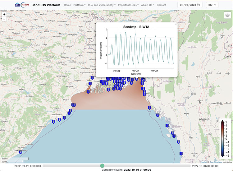
Forecasting cyclonic coastal flooding
Tested in the Bengal delta, the Band-SOS demonstrator is a pre-operational service for a coastal flood forecasting platform based on multispectral satellite images (Copernicus Sentinel-2). In operation since January 2023, the tool is used daily by the Bangladesh Flood Forecasting and Warning Center (FFWC).
Band-SOS provides a real-time forecast of the risk of flooding when a tropical cyclone strikes the coastline, coupled with a map of the vulnerability of populations at risk.
🟢 Free access
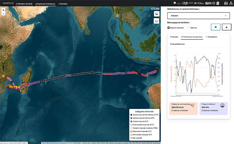
Monitoring cyclonic impacts in the Indian Ocean
Cimopolée is an interactive web mapping service for monitoring the impact of cyclones in the south-west Indian Ocean. Clear and intuitive, the tool displays the presence and trajectory of a cyclone in the OI zone in real time and provides more comprehensive information on the major cyclones of the last ten years. The data and associated background information can be downloaded for more detailed analysis using GIS or statistical software.
🟢 Free access
🟢 Open source algorithmic code
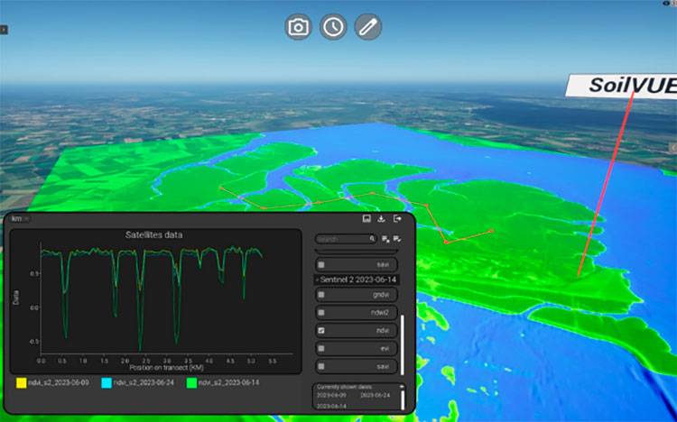
A digital twin to monitor wetland restoration
EO4Wetlands has developed a digital twin that merges satellite and in situ data in an interactive and scalable interface. Combining cloud infrastructure, high-performance 2D and 3D/4D visualization, and rich datasets, it allows users to explore changes in vegetation and soil water content over time and space. Using these key indicators, users can analyze the environmental dynamics of study sites, such as the correlations between tides, precipitation, and soil dynamics.
🟢 Open access

Managing hydrometeorological crises in real time
Developed in the Republic of Haiti, the GadeLapli system can be used anywhere in the world. Fed in real time with data from the COSPARIN programme, the 2D/3D platform displays rainfall estimates by analyzing satellite images and potentially flood-prone areas. Real-time support for the civil protection authorities, with the system complemented by the sending of e-mail or SMS alerts and indicators for monitoring the development of extreme hydrometeorological events.
🔵 Service marketed by Predict Services
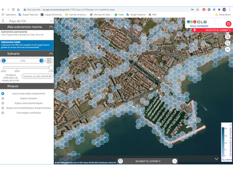
Estimating coastal flooding
Created by CLS to help coastal areas reduce their vulnerability to rising sea levels, the interactive LITTOSCOPE interface allows users to visualise several scenarios of rising sea levels, with or without a ten-year storm.
The tool also offers an assessment of the impacts (human, economic, heritage, environmental) generated.
🔵 A commercial service, access to Littoscope requires an account and password.
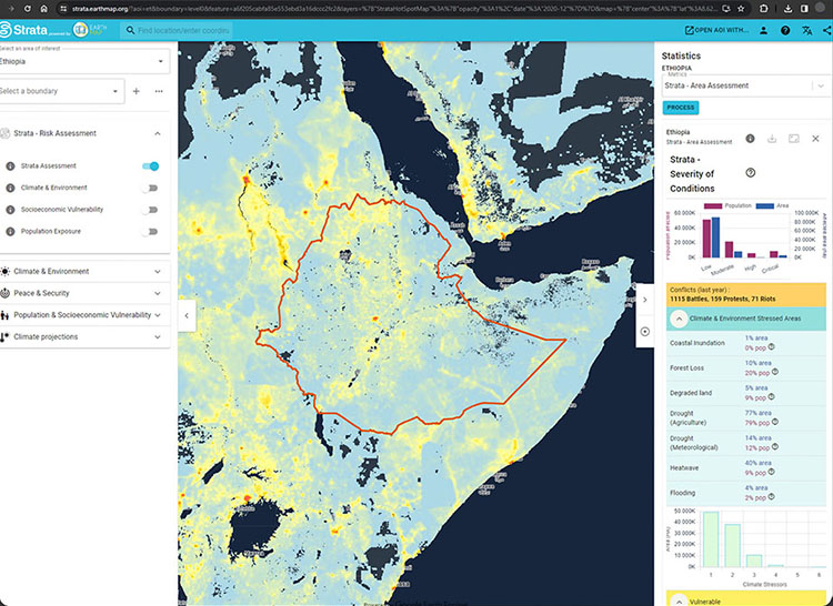
Visualizing complex risks for informed action
The links between environmental change, climate stress, conflict and the vulnerability of populations are complex, and access to data on these subjects is not straightforward. The result of a collaboration between Earth Blox, the United Nations Environment Programme (UNEP) and the University of Edinburgh, Strata brings together data from a variety of sources to see and locate 'hotspots' - those areas most at risk.
🟢 Free access
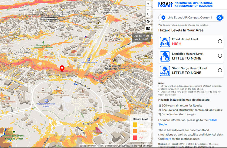
Nationwide Operational Assessment of Hazards for the Philippines
Supported by the Philippine Department of Science and Technology, UP NOAH aims to provide accurate and accessible data on extreme weather events. The NOAH platform offers maps of landslides, flooding and storm surges risk for the Philippines. The ‘NOAH Studio’ tab allows users the option to turn off or on the various hazard map overlays. The downloadable maps and data use the ESRI shapefile format to facilitate the use of existing GIS software.
🟢 Free access