

SCO France: 2023 Edition
Stay tuned: this article will be updated regularly to include the links towards projects’ presentations.
URBAN ADAPTATION: 3 projects
Supported by ARGANS
The GreenSpace project proposes to develop a tool for assessing the ecosystem services provided by trees, particularly in the context of urban reforestation plans initiated by local authorities to address the issues of air pollution, the increase in greenhouse gases (GHG) and urban heat islands.
GreenSpace uses space remote sensing (very high-resolution WorldView and Pleiades imagery) to provide different maps of inventories and to estimate the environmental benefits of the tree heritage at the scale of a city Based on the results of its first demonstrator deployed over a dozen years in three cities (Aix-en-Provence (France), Florence (Italy), and Kaunas (Lithuania)), the SCO GreenSpace project will extend the prototyping to Valencia (Spain) and Bucharest (Romania) in order to improve the methodology and develop strategic recommendations.
Supported by UMR LETG (CNRS University of Rennes 2)
The ALTELYS project aims to develop a tool to support the territorial and energy transition of urban buildings. It is intended for scientific actors and local authorities in metropolitan France and Brazil.
ALTELYS relies on multiple and heterogeneous data, including satellite imagery (Landsat 8/9, Sentinel-2/3, Pleiades, etc.) to produce a real-time map of urban heat islands that will help guide territorial management and strengthen the resilience of cities in the fight against climate challenges. The tool will give an important place to citizen collaboration through the collection of participatory data.
Supported by VITO - Flemish Institute for Technological Research
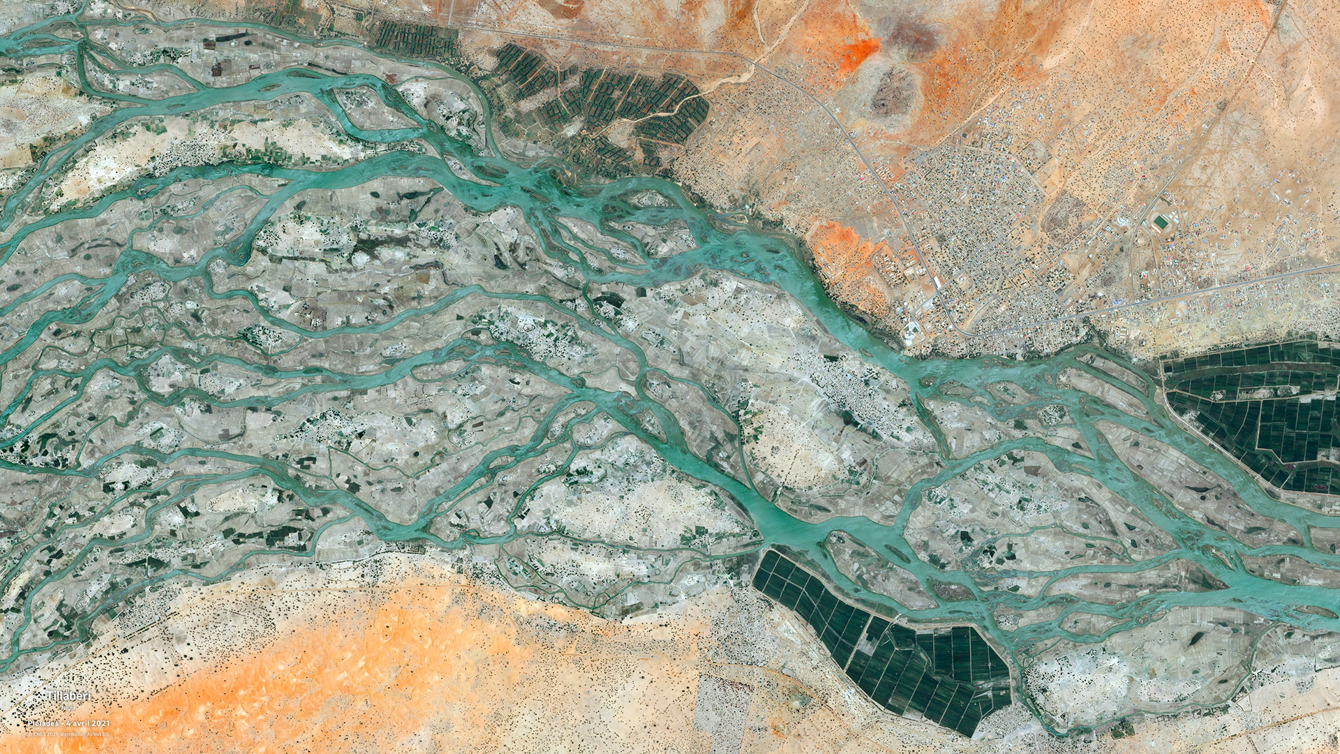
The exposure of urban areas to extreme heat waves is increasing, particularly in African cities with high population growth. With the ambition to develop a decision support tool for resilient urban planning, the SAFARI project will address the lack of appropriate local climate information by using satellite data from the Copernicus Climate Data Store, Pleiades or Skysat. Their combination with local socio-economic data will allow the construction of sectorial maps of current and future climate risks, at several scales, taking into account urban growth scenarios. Through its dynamic and evolving approach to the urban landscape, integrating a 3D visualization, the SAFARI project will support the managers of Niamey territory (Niger) in the evaluation of the effects of urban green infrastructures on local exposure to heat.
The tool can be replicated in other African cities and will be designed to support political decision-makers, civil society organizations and companies in developing adaptation strategies.
AGRICULTURE : 2 projects
-
Mérimée (Mekong Rice Methane Emissions)
Supported by GlobEO
Through its two components dedicated to the impacts of slow onset climate phenomena (Vimesco-Rice) and extreme events (VietARRO) on Vietnamese rice cultivation, the VietSCO project has aroused strong interest among many actors in the political, scientific and technical communities of Vietnam. In order to support Vietnam's Low Carbon Strategy for rice cultivation, a priority pillar for reducing the country's methane emissions, the VietSCO Merime project proposes to enhance the application as a decision support tool, particularly for irrigation water management.
Integrating new data such as forest cover (which is a methane sink), estimation of methane emissions from rice fields and coastal vulnerability, the project relies on the synergy between satellite data (ALOS-PALSAR, Sentinel-1, Pleiades, Pleiades NEO) and in-situ data to develop a dynamic mapping tool adapted to the challenges of the Vietnamese coastal strip.
Supported by the CRTS (Royal Centre for Remote Sensing)
Due to its geographical position, Morocco is exposed to many climatic challenges which particularly impact agricultural production, an important lever for the national economy. By combining high-resolution satellite data from Sentinel-2 with in situ data (rainfall, temperature, evapotranspiration, etc.) available at the scale of the cultivated plot, the AssurAgri project aims to generate an index of agricultural production loss in correlation with the indicators proposed by the IRRISAT-Morocco SCO project (irrigated areas, surface moisture maps, crop water requirements).
The project will thus support various drought-related decision makers such as agricultural insurance companies and relevant departments of the Ministry of Agriculture. Based on a composite drought index that evolves over the agricultural season, the mapping tool will contribute to the development and implementation of adaptation plans and mitigation activities.
BIODIVERSITY: 2 projects
Supported by University of Rennes 1, UMR CNRS 6553 EcoBio
The Cartovege 2 project proposes to develop and optimize the natural habitat mapping methodology developed on Cartovege, and to transpose it to two other islands of the French Southern Territories National Nature Reserve (RNN TAF), Saint-Paul and Amsterdam.
By combining naturalistic and environmental data with high spatial resolution satellite imagery (Pleiades, Pleiades NEO, Spot 6/7, etc.), the monitoring tool will enable the managers of the TAF RNN territory to assess the dynamics of the vegetation, particularly within the framework of the ecological restoration project implemented on the island of Amsterdam.
Supported by Bluecham SAS
Following on the TAHATAI project, which enabled the development of a digital platform for monitoring coastal and maritime areas in Arutua and Tahiti, TAHATAI Neo aims to extend the application to the whole of French Polynesia, and then internationally (Vanuatu, Fiji, India).
The project combines recent satellite data sources, at multiple scales, and third-party data (drone, crowdsourcing, topographic and bathymetric surveys) to propose an evolution of the platform as an operational decision-making tool. TAHATAI Neo is aimed at scientific actors and decision-makers from the French Polynesian Ministries in charge of Marine Spatial Planning, focused on the preservation of the blue resource and the uses of lagoon and coastal waters, but also at the NGO and industrial communities.
CARBON: 2 projects
Supported by WaltR
The aim of the EDISON project is to enhance existing inventories of atmospheric pollutants in French cities by focusing on emission sources. EDISON proposes a monitoring tool combining satellite data (Sentinel-5P, Sentinel-3), existing inventories, atmospheric modelling, but also data on real-time activities (transport, buildings, industries, land use, etc.) and socio-economic data.
By improving the measurement accuracy, spatial resolution and timeliness of greenhouse gas (CO2) and air quality (NO2/NOx, PM1/PM2.5) emission inventories, EDISON will help municipal managers and regulators visualize the impact of their activities and identify reduction opportunities to implement priority action plans.
Supported by Stockholm University
Blue carbon represents the portion of atmospheric carbon captured by oceanic and coastal ecosystems. Historically, its study has focused on the long-term storage of organic carbon produced by coastal vegetation, such as tidal marshes, mangroves and seagrass beds. Today, the assessment of blue carbon storage is a strategic issue for the climate, both to ensure the proper management of these ecosystems that provide habitats and spawning grounds for fish, and for their inclusion in net emissions calculations.
The SwedCoast-BlueCarb project focuses on the coastal ecosystems of four Swedish bays in the Baltic Sea. By combining satellite data (Sentinel-2 and 3), field measurements and expert knowledge, the project will develop a mapping tool capable of identifying underwater vegetation, soil types, land uses and the impact of these uses on coastal water quality. The tool developed in this way will be used to guide climate change adaptation policies.
WATER MANAGEMENT: 1 project
Supported by Brockmann Geomatics Sweden AB and Swedish National Space Agency
Within the framework of the European Water Framework Directive (WFD), the managers of water and aquatic environments in the EU countries are organizing themselves to meet the objectives of quality and protection of the resource.
Using Sentinel-2, Sentinel-3 and Landsat satellite data and in-situ quality parameters (turbidity, chlorophyll content, microbiological presence, etc.), the EO4WFD project aims to develop water quality indicators adapted to three large Swedish lakes, which are priority sources for drinking water supply. Developed in collaboration with local stakeholders, the results will improve existing ecological models and contribute to the classification of water bodies and the evaluation of quality factors for the Swedish implementation of the WFD.
WATER MANAGEMENT/AGRICULTURE: 1 project
Supported by MEOSS and INSIGHT
The objective of the EO4AgriWater project is to provide a Decision Support Tool (DST) in the form of a web-mapping application to public and private stakeholders in the fields of agriculture and water management in New Caledonia and metropolitan France (Alsace, Gers).
By capitalizing on the knowledge acquired from three SCO projects on drought monitoring (EO4DM), water body monitoring (MEO-Climate) and irrigation monitoring (Space4Irrig), EO4AgriWater aims to bring together several indicators for a representation that can be customized and is specific to the challenges of the territories. The combination of satellite data (such as Copernicus Sentinel-1 and 2, Landsat 7/8, MODIS) and in-situ data (meteorological, cultivation practices, etc.) will make it possible to propose a strategic DST for monitoring water needs, particularly in agriculture, for integrated management of the resource, in line with the constraints imposed by climate change.
HEALTH: 1 project
Supported by DIGINOVE and IRD
In a context of worsening air pollution in southern countries, health and air quality monitoring stakeholders are faced with major health, environmental and economic issues, and lack reliable data to assess the consequences of this pollution on human health.
The AirCrowd Africa project, which is being tested in West Africa, aims to develop an innovative "multifunctional" technical solution capable of monitoring air pollution levels and assessing their impact by merging different data sources (terrestrial and spatial environmental data, real-time health data and big data). The objective is to produce high resolution maps and model alternative urban development strategies for the cities of Cotonou, Dakar and Abidjan.
VULNERABILITY AND ADAPTATION TO NATURAL DISASTERS: 2 projects
Supported by UMR CNRS, University of Rouen Normandy
Located at the interface between land and sea, intertidal areas are very important natural buffer zones for the protection of coastal regions. Human interventions and the effects of climate change have greatly weakened these areas, which are difficult to monitor because of the strong variations in water levels. The EO4InterTopo project proposes to monitor, in the Normandy context (France), the evolution of these areas through mapping tools (topography, substrate characterization, vegetation) in order to assist coastal defense and ecosystem management stakeholders in their decision-making. The project is based on the use of several satellite missions such as Sentinel-1, Sentinel-2, Landsat, Pleiades, Icesat-2 and SWOT series, to enrich the work of CNRS researchers.
Supported by IRD/LEGOS
The WACA-VAR (West African Coastal Areas- mapping Vulnerability, Adaptability and Resilience) project is part of an effort to improve knowledge of the impacts of climate change on coastal and marine ecosystems in West Africa.
WACA-VAR aims to develop a Web-GIS platform based on satellite data (Sentinel-1, Sentinel-2, VENUS, Pleiades (Neo), CFOSAT, SWOT and CO3D), in order to provide relevant indicators for the development of public policies for coastal and marine ecosystem management and risk mitigation. This operational project is aimed at the WARCO community (West African Regional Coastal Observatory located in Dakar), scientific actors and political decision-makers (municipalities and Ministry of the Environment) of several West African countries (Senegal, Cameroon, Ghana, Benin, Ivory Coast, Nigeria).