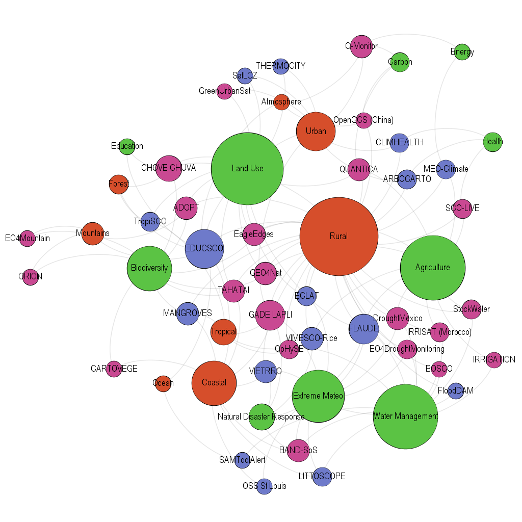
SCO France: the 2021 edition
AGRICULTURE: 2 projects
- Space4Irrig
Sponsored by the CESBIO (Centre for the Study of the Biosphere from Space)
The aim of the Space4Irrig project is to provide, via an Internet platform, soil moisture maps with very high spatial resolution (scale of a plot of land), maps of irrigated crops and of the true water needs of crops in the Occitanie and PACA (Provence Alpes Côte d'Azur) regions. The soil moisture maps will be provided on 15 to 20 dates per month. The maps of the irrigated surface areas and water requirements will be provided at monthly intervals between 2017 and 2022. The end products will be delivered by MEOSS.
- SCOLive
Sponsored by ARI-ST
Olive tree farming, already a tricky business, is now subject to increasingly unpredictable climatic variations. SCOLive aims to create an observatory for mapping all the diseases and parasites that can affect the crops and thereby provide local public authorities with relevant decision-making aids. This project involves all the sector stakeholders (amateur and professional farmers, working individually or in groups, regional engineering players) and forms part of an ecosystem that has already been set up to contribute to the ecological transition project of the Grasse region, where olive groves are a central part of the local culture and the regional economy.
CARBON: 2 projects
- C-Monitor
Sponsored by LSCE (Climate and Environment Sciences Laboratory)
The ability to monitor greenhouse gas emissions is crucially important from both an environmental and health standpoint. C-MONITOR France is a tool which provides a daily and localised estimate of CO2 emissions of anthropic origin and of pollutants associated with the use of fossil energy sources, thanks to the joint utilisation of socio-economic and spaceborne remote-sensing data. Monitoring is set to cover the whole of France, with a focus on two specific regions, and will be made available to a wide range of stakeholders; regional and local authorities and their operators, industrial emitters of greenhouse gases, as well as citizens and opinion influencers (NGOs and others) in the form of easy-to-understand indicators.
- QUANTICA
Sponsored by Airbus DE GEO
Capturing CO2 in soil would reduce global warming. The QUANTICA project proposes a tool for evaluating, on the scale of agricultural plots of land, the carbon storage potential offered by the intermediate vegetation cover. The stakeholders in the agricultural chain, including cooperatives and environmental certification bodies, will be able to use the tool to fairly remunerate farmers who commit to applying these carbon storage practices.
BIODIVERSITY: 6 projects
- Cartovege
Sponsored by Rennes University
The rise in temperature has significant consequences on biodiversity, especially in the Alpine and Polar regions. Focusing on the territory of the French sub-Antarctic islands of Crozet and Kerguelen, the Cartovege project aims to develop a decision aid for the conservation of flora and preservation of habitats. By combining the map of the existing vegetation via satellite and field data with the predictive modelling of the changes that can affect it, this tool will provide for a better understanding and anticipation of the climate change-related risks that threaten the biodiversity of this region.
- TAHATAI
Sponsored by BLUECHAM
The coastal zone of Polynesia, where the sustained exchanges between land and sea are accompanied by a great diversity of uses - from fishing to habitat - is also very vulnerable to climatic hazards. Intended for the decision makers of the Iles du Vent ("Windward Islands") of French Polynesia, the aim of the Tahatai project is to develop and automate the collection and calculation of indicators that are useful for the governance of the coastal zone, based on spatial and field data. The resulting reliable information will not only provide better understanding of the changes brought about by global warming but also protect biodiversity and allow the identification of vulnerable areas on the coast in order to anticipate the potential risks.
- GEO4NAT
Sponsored by CLS/SIRS
While natural systems can be wonderful carbon sinks, this characteristic is not only frequently omitted from strategies for fighting global warming, but it is also endangered by the fragmentation and destruction of these environments. Consequently, the GEO4NAT project aims to design a decision support tool for preserving natural systems in the face of climate change and the uncontrolled development of land artificialisation. Thanks to an application called Web Carto, it will be possible to observe and assess the extent to which nature is present in a region and the carbon storage potential of its biomass. This project will be initiated in the Nouvelle Aquitaine region of France, then transposed to the Loire Atlantique département.
- ORION
Sponsored by CREA Mont-Blanc (CREA: Mountain Ecosystems Research Centre)
Heathland, a type of habitat characterised by relatively low thickets, is very common in mountains and forests, but its distribution and expansion are still not well known, especially in the Alps. To overcome this lack of information, the ORION project uses the progress in satellite imaging to develop a fine-grained map of the habitats along with indicators of biodiversity and of the risks of pastures giving way to heathland throughout the Community of Communes of Chamonix Mont-Blanc Valley. The results will be accompanied by photographic evidence showing the change in the landscapes over 30 years and will place the heathland dynamics in a broader context of landscape modifications induced by climate change.
- EO4Mountain-Pastoralism
Sponsored by A2S/Conectus
Wetlands render substantial ecosystem services and contribute greatly to the reduction of greenhouse gases. Yet recent climate change has already modified wetlands in mountain regions, transforming agro-pastoral practices and habitats. It is therefore becoming crucial to have operational monitoring tools that can document these environments and the way the ecosystem services rendered are changing. The EO4Mountain-Pastoralism project was tested in the Mercantour National Park using Sentinel-1 and 2 satellite images and has been designed to provide a toolbox that meets the needs of users. The project has set a dual goal to improve the way we monitor and understand these areas: firstly to produce relevant data at short intervals (15 days) to detect and monitor mountain wetlands, and secondly to develop a methodology and tools to statistically and physically link the variations in this data to indicators of the services rendered by these environments.
- MIGR-SAFE
Sponsored by CLS
If the preservation of migratory birds contributes to sustainable development, their pilgrimage is strongly affected by landscapes, human activities and climate change. Ensuring their journey and protecting their stopovers requires new collaborations between local authorities and scientists. MIGR-SAFE proposes new tools and usable data for each of them.
ADAPTATION TO NATURAL DISASTERS: 2 projects
- BanD-SOS
Sponsored by LEGOS/IRD
Every three years on average the Bengal Delta in Bangladesh is struck by a major tropical cyclone resulting in serious consequences. The BanD-SOS project endeavours to develop a response to this with a pre-operational system for forecasting (between 36 and 48 hours in advance) cyclonic flooding and the associated risk to society. The function of this system will be firstly to provide the real-time information necessary for triggering the population evacuation and protection operations when a cyclonic event occurs, and secondly to help develop public policies of adaptation to the submersion risk to ensure the resilience of the population over the medium-to-long term.
- GADE LAPLI
Sponsored by PREDICT Services
The development of spatial data collection and of our understanding of the climate systems now makes it possible, via the COSPARIN data, to estimate the quantity of precipitation over the entire globe at a very fine-grained level. The Gade Lapli project uses this new data to quantify the risks associated with extreme precipitation events in regions that are extremely vulnerable to climate change and often poorly equipped with forecasting means, such as Haiti. The tool will propose both the creation of an index for monitoring the changes in precipitation caused by climate change, particularly during the cyclone season, and a support service to monitor hydrometeorological hazards in real time and better anticipate them.
WATER MANAGEMENT: 5 projects
- OpHySE
Sponsored by Hydro Matters/LEGOS
Climate change risks causing substantial changes to the hydrological cycle, affecting rivers and their navigability in particular. In this respect, the OpHySE project aims to propose a platform for real-time monitoring of the condition of rivers and provide a navigability aid which will ultimately enable the way they evolve to be planned and predicted. This tool will be put into application for demonstration purposes on all the river basins of French Guiana, where the rivers are of major environmental and economic importance.
- StockWater
Sponsored by the CNES
Dams are strategic tools for countries and their management of water resources, the availability of which is already an essential issue and becoming more so all the time. StockWater aims to put in place a system for monitoring the load of dams based on satellite data, and a specific processing system, thereby facilitating the work of the public authorities in this area. The project, which will ultimately be open to any country wishing to participate, is being developed in France using a method whose reproducibility will initially be tried and tested over the whole of Europe as well as in India, where the necessary data is available. Other regions of interest will then be considered (Mekong basin, West Africa) before applying the system globally.
- BOSCO
Sponsored by Rennes University/CNRS
The BOSCO project has a dual goal: (1) Monitor the change in the water content of soils and the persistence of dry conditions in the Brittany region with respect to the scale of water management and water flows; (2) Co-construct decision aids for diagnosis, analysis and services with the stakeholders and managers, and support the public adaptation policies (water and agricultural resources, preservation of ecosystems). The final products will be delivered by the company KERMAP.
- EO4DroughtMonitoring
Sponsored by INSIGHT SAS
EO4DroughtMonitoring is a tool for characterising and monitoring drought on a regional scale. It is designed as a farm management aid and a decision aid for institutional bodies. The envisaged system is capable of assessing the intensity of periods of drought, estimating their severity by analogy with historical reference conditions and, when coupled with current data, providing an indication of the plausible future path of a hydrological season. The project will initially concern New Caledonia, where the drying up of rivers, soils and vegetation has significant consequences.
- SAMToolAlert
Sponsored by CLS (Collecte Localisation Satellites)
Satellite data can be used to monitor and anticipate massive arrivals of Sargassum seaweed in the Atlantic. CLS has developed and, since 2018, has been operating a service called SAMTool for monitoring and predicting where the Sargassum will be washed ashore. SAMTool deploys an operational chain based on the processing of daily satellite images, the use of a drift model, and the issuing of information to users through a web platform. The aim of SAMTool-Alert is to consolidate the use of SAMTool in the decision chain of each region. The project will produce local and regional indicators that will be used to determine the vulnerability of the region to the risk of Sargassum seaweed wash-up, on the basis of local environmental, economic and health issues (preservation of biodiversity, tourism, fishing, public health, collection and recycling).
LAND USE: 5 projects
- Eagle Hedges
Sponsored by TerraNIS
Hedges, no matter how common they may be in the agricultural landscape, play an important role as habitats for biodiversity and render numerous ecosystem services. It nevertheless remains difficult to assess their exact effect. The Eagle Hedges project meets this challenge by pursuing a dual goal of mapping and research. It consists firstly in setting up an operational service for extracting the surface areas and linear coverage of hedges in a given region in order to monitor how they evolve, and secondly of developing a robust tool for characterising the network of hedgerows and its functions in various regions.
- ADOPT
Sponsored by Espace et Living Labs (E2L)
The aim of Regional Natural Parks in France is to allow the sustainable development and conservation of their region's heritage, which implies anticipating and countering the effects of climate change. The aim of the ADOPT project is to define, prototype and test a service for producing and distributing climate change impact indicators - based on Earth observation satellite data - for the Regional Natural Parks of Occitanie, which occupy one quarter of the region's surface area.
- CHOVE-CHUVA
Sponsored by CNRS/UMR LETG
The objective of the CHOVE-CHUVA project is to develop a tool for distributing the information produced by scientific teams recently involved in various projects monitoring regional dynamics in the state of Mato Grosso in Brazil. The aim is to make this tool simple and user-friendly so that it will be accessible to as many people as possible, especially the general public: users will simply have to indicate the name of a municipality or identify an area of interest, such as a farm, and the system will provide a series of synthetic indicators on the change in the climatic variables and the dynamics of land occupation (forest, agriculture, water resources) and land use ("low-carbon" agricultural practices), and a "regional vulnerability" indicator.
- Green Urban Sat
Sponsored by CEREMA (Centre of Studies and Expertise on Risks, the Environment, Mobility and Development)
To counter the phenomena of heat islands, heavily urbanised areas have a lot to gain from turning to solutions based on nature and the integration of vegetation. Yet it remains difficult to fully understand the effect and the effectiveness of these solutions. The Green Urban Sat project focuses on developing - on the basis of multi-source satellite images - methods of quantitatively and qualitatively assessing the ecosystem services rendered by the urban vegetation. In other words, the goal is to provide a fine-grained description of urban vegetation in order to see its effects, especially its benefits, with regard to climate change within the wider urban area. The demonstrator will be developed on the Greater Nancy Metropolis before testing its reproducibility on other regions.
- TropiSCO
Sponsored by GlobEO
Despite their vital role, forest surface areas are being drastically reduced year after year, especially in tropical zones. TropiSCO therefore aims to develop a platform for the weekly monitoring of global tropical deforestation by means of Sentinel-1 radar images. This project will benefit from close collaboration with a number of partner countries in French-led programmes in the Amazon, Congo and South-East Asian basins to adapt the sensing tool to their needs. There are many potential uses for the TropiSCO data, such as combating illegal forestry and mining operations, illicit agricultural crops and wild animal trafficking, as well as providing readily usable data and statistics. This could interest many different users, such as governments, NGOs, forest fire monitoring services, universities, the general public, or even companies looking to reduce the risk of deforestation in their supply chains.
35 projects in totalAdded to the 14 projects of the 2020 vintage, SCO France supports a total of 35 projects.